Enable Location

We need your location to show you interesting places around you

Discover nearby places

Find interesting locations and hidden gems around you

Precise directions

Get accurate directions and distances to places

Your location is never shared with other users. It's only used when you tap the location button.

Millers Ferry Lock and Dam

Log in to your account

Start exploring — it's free

Trusted by 63,122 travelers worldwide

Continue with Google
Continue with Apple
or

We will send you a code to connect

By continuing, you accept our Terms and Conditions and our Privacy Policy

Check your inbox

We've sent a pincode in your inbox. Please enter the code below.

Millers Ferry Lock and Dam
Discussion Reviews 1 Photos
2.2k Popularity

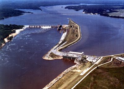
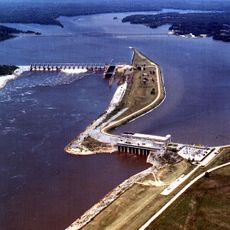
Millers Ferry Lock and Dam, Hydroelectric power station and lock on the Alabama River in Wilcox County, US.

Millers Ferry Lock and Dam is a water management and power generation facility on the Alabama River featuring a 600-foot-long lock chamber and hydroelectric generators. The structure controls water levels in the river and enables vessels to move safely between different elevations.

Construction began in 1963 under the United States Army Corps of Engineers as part of a broader plan to manage the Alabama River system. The project was completed in 1974, transforming the river and surrounding landscape.

The reservoir draws boaters, anglers, and bird watchers who come to experience the water and observe wildlife in their natural setting. Recreation has become central to how local communities use this waterway today.

The lock operates daily for vessel traffic, and visitors can watch the process from designated viewing areas around the facility. The surrounding shoreline offers multiple access points, though popular spots can become crowded during peak seasons.

The lock is operated seasonally to allow fish to migrate upstream into inland waters, a practice that reflects efforts to balance energy production with ecological needs. Few visitors realize the facility actively supports fish populations through these timed water releases.

The community of curious travelers

AroundUs brings together thousands of curated places, local tips, and hidden gems, enriched daily by 60,000 contributors worldwide.

Start exploring
Location
Inception
1963
GPS coordinates
32.10080,-87.40000
Latest update
December 13, 2025 17:08
Around this place
Faunsdale Plantation
United States of America

Faunsdale Plantation

41.8 km
Cahaba Prison
United States of America

Cahaba Prison

37.3 km
Adams Grove Presbyterian Church
United States of America

Adams Grove Presbyterian Church

39.7 km
Fairhope Plantation
United States of America

Fairhope Plantation

39.3 km
Cedar Grove Plantation
United States of America

Cedar Grove Plantation

42 km
Snow Hill Normal and Industrial Institute
United States of America

Snow Hill Normal and Industrial Institute

35.8 km
St. Luke's Episcopal Church
United States of America

St. Luke's Episcopal Church

36.9 km
Half Chance Iron Bridge
United States of America

Half Chance Iron Bridge

37.2 km
William "Bill" Dannelly Reservoir
United States of America

William "Bill" Dannelly Reservoir

2.1 km
Westwood
United States of America

Westwood

41.4 km
William Poole House
United States of America

William Poole House

36 km
New Hope Baptist Church
United States of America

New Hope Baptist Church

43.5 km
Street Manual Training School
United States of America

Street Manual Training School

32.1 km
William King Beck House
United States of America

William King Beck House

8.7 km
C. S. Golden House
United States of America

C. S. Golden House

28.6 km
Uniontown Historic District
United States of America

Uniontown Historic District

41.4 km
Oak Hill Historic District
United States of America

Oak Hill Historic District

36 km
Ackerville Baptist Church of Christ
United States of America

Ackerville Baptist Church of Christ

32.2 km
Airmount Grave Shelter
United States of America

Airmount Grave Shelter

29.3 km
Carlowville Historic District
United States of America

Carlowville Historic District

35 km
Furman Historic District
United States of America

Furman Historic District

42.3 km
Thomaston Colored Institute
United States of America

Thomaston Colored Institute

28.9 km
Wilcox Female Institute
United States of America

Wilcox Female Institute

15.5 km
Wilcox County Courthouse Historic District
United States of America

Wilcox County Courthouse Historic District

16.1 km
Thomasville Historic District
United States of America

Thomasville Historic District

38 km
Patrick Farrish House
United States of America

Patrick Farrish House

27.9 km
Thomaston Central Historic District
United States of America

Thomaston Central Historic District

28.3 km
Rikard's Mill Historical Park
United States of America

Rikard's Mill Historical Park

39.1 km
Show the full map
Reviews
Share your experience

No review yet

Discussions
Start a discussion...

No discussion yet

« Millers Ferry Lock and Dam - Hydroelectric power station and lock on the Alabama River in Wilcox County, US » is provided by Around Us (aroundus.com). Images and texts are derived from Wikimedia project under a Creative Commons license. You are allowed to copy, distribute, and modify copies of this page, under the conditions set by the license, as long as this note is clearly visible.

Discover hidden gems everywhere you go!

From secret cafés to breathtaking viewpoints, skip the crowded tourist spots and find places that match your style. Our app makes it easy with voice search, smart filtering, route optimization, and insider tips from travelers worldwide. Download now for the complete mobile experience.

Around Us App Screenshot

A unique approach to discovering new places

Le Figaro

All the places worth exploring

France Info

A tailor-made excursion in just a few clicks

20 Minutes

Around Us
Travel Guide & Maps
Download

Send to your phone

QR Code
1

Open the camera app on your mobile.

2

Point at the QR code with your camera. A notification will appear.

3

Tap the notification to open the link.