Enable Location

We need your location to show you interesting places around you

Discover nearby places

Find interesting locations and hidden gems around you

Precise directions

Get accurate directions and distances to places

Your location is never shared with other users. It's only used when you tap the location button.

R.E. "Bob" Woodruff Lake

Log in to your account

Start exploring — it's free

Trusted by 62,500 travelers worldwide

Continue with Google
Continue with Apple
or

We will send you a code to connect

By continuing, you accept our Terms and Conditions and our Privacy Policy

Check your inbox

We've sent a pincode in your inbox. Please enter the code below.

R.E. "Bob" Woodruff Lake

R.E. "Bob" Woodruff Lake, body of water

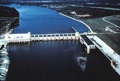
R.E. "Bob" Woodruff Lake is a large reservoir along the Alabama River in central Alabama, stretching between Montgomery and Selma. The water mostly follows the natural river channel and is held back by the Robert F. Henry Dam, with the lake covering about 12,500 acres (5,100 hectares) and reaching depths of 25 feet (7.6 meters) at its deepest point.

The lake was created by building the Robert F. Henry Dam to hold back the Alabama River, forming a large water storage area. Since its completion in 1975, the lake has supported river navigation, generated electricity for thousands of homes, and helped control flooding during heavy rains in spring and winter.

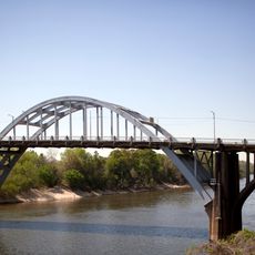
Locals often refer to the area by its original name, the Alabama River, since the water follows the natural river flow through the land. Fishing and boating are woven into the daily life of the community, with families and groups gathering at the water year-round.

Many boat ramps are located at different spots around the lake, including Crommelin Landing, Fort Toulouse, Benton, and Holy Ground Battlefield Park. The area offers campgrounds run by the U.S. Army Corps of Engineers with options ranging from full-service facilities to basic tent camping, and spring and fall offer the most comfortable weather for visiting.

The lake is known for its excellent bass fishing, especially when the dam gates release water and create currents that draw Alabama bass to feed in the main channel. At the same time, quiet backwaters fill with largemouth bass, making the lake a dynamic fishing destination that changes based on water flow.

The community of curious travelers

AroundUs brings together thousands of curated places, local tips, and hidden gems, enriched daily by 60,000 contributors worldwide.

Start exploring
Location
GPS coordinates
32.32640,-86.78250
Latest update
February 9, 2026 07:45
Around this place
Edmund Pettus Bridge
United States of America

Edmund Pettus Bridge

23.9 km
Cahaba
United States of America

Cahaba

30 km
Brown Chapel A.M.E. Church
United States of America

Brown Chapel A.M.E. Church

24 km
National Voting Rights Museum
United States of America

National Voting Rights Museum

23.6 km
Sturdivant Hall
United States of America

Sturdivant Hall

25.1 km
Adams Grove Presbyterian Church
United States of America

Adams Grove Presbyterian Church

24.1 km
Meadowlawn Plantation
United States of America

Meadowlawn Plantation

17.1 km
First Baptist Church
United States of America

First Baptist Church

24.2 km
Riverdale
United States of America

Riverdale

14.5 km
Joseph T. Smitherman Historic Building
United States of America

Joseph T. Smitherman Historic Building

24.5 km
John Tyler Morgan House
United States of America

John Tyler Morgan House

25 km
Lowndesboro Historic District
United States of America

Lowndesboro Historic District

17.4 km
Wesley Plattenburg House
United States of America

Wesley Plattenburg House

24.6 km
St. Paul's Episcopal Church
United States of America

St. Paul's Episcopal Church

24.3 km
Lassiter House
United States of America

Lassiter House

16.4 km
Old Town Historic District
United States of America

Old Town Historic District

24.7 km
United States Post Office Building
United States of America

United States Post Office Building

24.2 km
Lowndes County Courthouse
United States of America

Lowndes County Courthouse

25 km
Valley Creek Presbyterian Church
United States of America

Valley Creek Presbyterian Church

27.9 km
Pleasant Hill Presbyterian Church
United States of America

Pleasant Hill Presbyterian Church

21.5 km
Marcus Meyer Skinner House
United States of America

Marcus Meyer Skinner House

26.6 km
Summerfield District
United States of America

Summerfield District

23.8 km
J. Bruce Hain House
United States of America

J. Bruce Hain House

19.7 km
Water Avenue Historic District
United States of America

Water Avenue Historic District

23.8 km
Icehouse Historic District
United States of America

Icehouse Historic District

25.2 km
Riverview Historic District
United States of America

Riverview Historic District

24.8 km
Sullivan and Richie Jean Jackson House
United States of America

Sullivan and Richie Jean Jackson House

25.6 km
Slavery & Civil War Museum
United States of America

Slavery & Civil War Museum

23.7 km
Show the full map
« R.E. "Bob" Woodruff Lake - body of water » is provided by Around Us (aroundus.com). Images and texts are derived from Wikimedia project under a Creative Commons license. You are allowed to copy, distribute, and modify copies of this page, under the conditions set by the license, as long as this note is clearly visible.

Discover hidden gems everywhere you go!

From secret cafés to breathtaking viewpoints, skip the crowded tourist spots and find places that match your style. Our app makes it easy with voice search, smart filtering, route optimization, and insider tips from travelers worldwide. Download now for the complete mobile experience.

Around Us App Screenshot

A unique approach to discovering new places

Le Figaro

All the places worth exploring

France Info

A tailor-made excursion in just a few clicks

20 Minutes

Around Us
Travel Guide & Maps
Download

Send to your phone

QR Code
1

Open the camera app on your mobile.

2

Point at the QR code with your camera. A notification will appear.

3

Tap the notification to open the link.