Enable Location

We need your location to show you interesting places around you

Discover nearby places

Find interesting locations and hidden gems around you

Precise directions

Get accurate directions and distances to places

Your location is never shared with other users. It's only used when you tap the location button.

Log in to your account

Start exploring — it's free

Trusted by 65,853 travelers worldwide

Continue with Google
Continue with Apple
or

We will send you a code to connect

By continuing, you accept our Terms and Conditions and our Privacy Policy

Check your inbox

We've sent a pincode in your inbox. Please enter the code below.

Discussion Reviews Photo
4.3k Popularity

Lay Dam, Hydroelectric power station on Coosa River, Alabama.

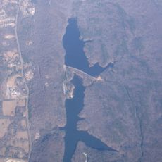
Lay Dam is a concrete gravity dam on the Coosa River in central Alabama, sitting on the county line between Chilton and Coosa Counties near the town of Clanton. The dam operates as a run-of-the-river hydroelectric station and backs up the river to form Lay Lake, a large reservoir that stretches through the surrounding hills.

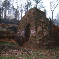
The dam was completed in 1914 as the Alabama Power Company's first major power project. Its construction flooded the site of Fort Williams, a post that had been used during the Creek War in the early 1800s.

The name Lay Dam honors William Patrick Lay, who worked to secure approval for the project in Washington. Visitors who know this history see the dam not just as a structure, but as a reminder of how personal effort shaped the region's development.

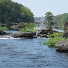
Several public access points around Lay Lake give visitors different ways to reach the water and view the dam from various angles. Conditions along the shore change with the seasons, so it is worth checking local reports before heading out, especially for fishing or boating.

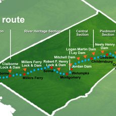
Before 1929, the dam was known as Lock 12 Dam, a name that reflected its place in a numbered series of river infrastructure projects. The renaming after William Patrick Lay was unusual because it honored a living individual rather than a place or an event.

The community of curious travelers

AroundUs brings together thousands of curated places, local tips, and hidden gems, enriched daily by 60,000 contributors worldwide.

Start exploring
Location
GPS coordinates
32.96370,-86.51670
Latest update
March 3, 2026 10:06
Around this place
Pinhoti National Recreation Trail
United States of America

Pinhoti National Recreation Trail

15.2 km
Oak Mountain State Park
United States of America

Oak Mountain State Park

45.9 km
Jordan Lake
United States of America

Jordan Lake

45.4 km
Alabama National Cemetery
United States of America

Alabama National Cemetery

35.1 km
Mount Sinai School
United States of America

Mount Sinai School

46.1 km
Kymulga Mill & Covered Bridge
United States of America

Kymulga Mill & Covered Bridge

46 km
Alabama Confederate Soldiers Home
United States of America

Alabama Confederate Soldiers Home

27.3 km
Alabama Scenic River Trail
United States of America

Alabama Scenic River Trail

4.7 km
Brierfield Furnace
United States of America

Brierfield Furnace

41.2 km
Shelby Iron Company
United States of America

Shelby Iron Company

18 km
Desoto Caverns Family Fun Park
United States of America

Desoto Caverns Family Fun Park

44.2 km
Edmund King House
United States of America

Edmund King House

35.9 km
Old Rock House
United States of America

Old Rock House

42.1 km
Old Shelby County Courthouse
United States of America

Old Shelby County Courthouse

25.2 km
Montebrier
United States of America

Montebrier

37.3 km
Coosa County Jail
United States of America

Coosa County Jail

28.9 km
Verbena United Methodist Church
United States of America

Verbena United Methodist Church

23.9 km
McKibbon House Bed & Breakfast
United States of America

McKibbon House Bed & Breakfast

35.5 km
Walker-Klinner Farm
United States of America

Walker-Klinner Farm

32.5 km
B. B. Comer Memorial Library
United States of America

B. B. Comer Memorial Library

34.4 km
Driskell-Martin House
United States of America

Driskell-Martin House

50.9 km
Goodwin-Hamilton House
United States of America

Goodwin-Hamilton House

19.7 km
Tinglewood Carvings
United States of America

Tinglewood Carvings

35.1 km
Downtown Montevallo Historic District
United States of America

Downtown Montevallo Historic District

35.7 km
Calera Downtown Historic District
United States of America

Calera Downtown Historic District

26.7 km
William Averiett House
United States of America

William Averiett House

21.9 km
Flag Mountain Lookout Tower
United States of America

Flag Mountain Lookout Tower

15.2 km
University of Montevallo Historic District
United States of America

University of Montevallo Historic District

36.1 km
Show the full map
Reviews
Share your experience

No review yet

Discussions
Start a discussion...

No discussion yet

« Lay Dam - Hydroelectric power station on Coosa River, Alabama » is provided by Around Us (aroundus.com). Images and texts are derived from Wikimedia project under a Creative Commons license. You are allowed to copy, distribute, and modify copies of this page, under the conditions set by the license, as long as this note is clearly visible.

Discover hidden gems everywhere you go!

From secret cafés to breathtaking viewpoints, skip the crowded tourist spots and find places that match your style. Our app makes it easy with voice search, smart filtering, route optimization, and insider tips from travelers worldwide. Download now for the complete mobile experience.

Around Us App Screenshot

A unique approach to discovering new places

Le Figaro

All the places worth exploring

France Info

A tailor-made excursion in just a few clicks

20 Minutes

Around Us
Travel Guide & Maps
Download

Send to your phone

QR Code
1

Open the camera app on your mobile.

2

Point at the QR code with your camera. A notification will appear.

3

Tap the notification to open the link.