Alabama Scenic River Trail, National water trail in Alabama, United States
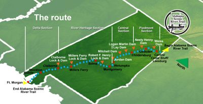
The Alabama Scenic River Trail is a 631-mile water route that stretches across the state, connecting multiple river systems from Weiss Lake to the Gulf of Mexico. The route provides over 100 access points and numerous campsites for various water sports activities.
The route received recognition as a National Recreation Trail from the US Department of Interior in 2009 and was additionally certified as a National Water Trail in 2012. These two designations highlighted its importance as an established paddling connection in the southeastern water system.
Local people living along the route have developed a long tradition of hospitality for paddlers, often offering overnight spots spontaneously. This informal support from community members shapes how travelers experience the journey today.
The route offers various access points distributed along its entire length, with licensed outfitters handling equipment rental and guided tours. Plan your trip based on water levels and season, as these factors significantly affect conditions along the way.
The Great Alabama 650 is an intense competition where paddlers attempt to complete the entire route nonstop in 10 days. This race draws ambitious athletes who want to test their endurance on one of the longest continuous water routes.
The community of curious travelers
AroundUs brings together thousands of curated places, local tips, and hidden gems, enriched daily by 60,000 contributors worldwide.