Enable Location

We need your location to show you interesting places around you

Discover nearby places

Find interesting locations and hidden gems around you

Precise directions

Get accurate directions and distances to places

Your location is never shared with other users. It's only used when you tap the location button.

Kilbourne Hole

Log in to your account

Start exploring — it's free

Trusted by 62,031 travelers worldwide

Continue with Google
Continue with Apple
or

We will send you a code to connect

By continuing, you accept our Terms and Conditions and our Privacy Policy

Check your inbox

We've sent a pincode in your inbox. Please enter the code below.

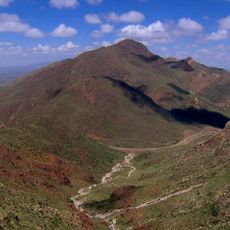
Kilbourne Hole, Volcanic crater in Doña Ana County, New Mexico, US.

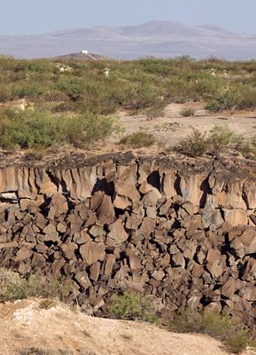
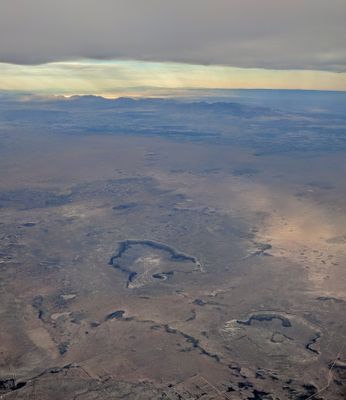
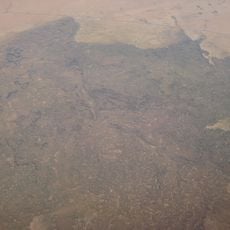
Kilbourne Hole is a large elliptical basin formed by volcanic activity in the New Mexico desert. The depression sinks several hundred feet deep into the earth and measures roughly 1.7 miles along its length and over a mile across its width.

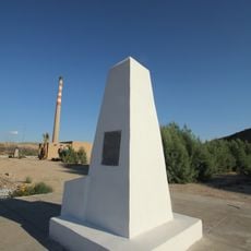
The basin formed thousands of years ago when volcanic eruptions brought hot material from deep within the earth to the surface. Federal authorities recognized its geological importance and protected it as a National Natural Landmark in 1975.

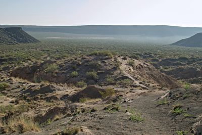
NASA selected this location for training Apollo astronauts in 1969 and 1970, preparing them for geological studies during lunar missions.

The site sits in a remote desert area and can be viewed from nearby vantage points, though some sections of the land are privately owned. It is wise to check with local authorities before planning a visit to understand which areas are open to the public.

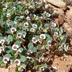
The crater contains mineral fragments with yellow and green crystal formations that come from deep layers of the earth. These rare samples give scientists direct insight into the composition of materials far beneath the planet's surface.

The community of curious travelers

AroundUs brings together thousands of curated places, local tips, and hidden gems, enriched daily by 60,000 contributors worldwide.

Start exploring
Location
Location
GPS coordinates
31.97204,-106.96473
Latest update
December 8, 2025 19:40
Around this place
Sun Bowl Stadium
United States of America

Sun Bowl Stadium

48.5 km
El Paso High School
United States of America

El Paso High School

50 km
Franklin Mountains State Park
United States of America

Franklin Mountains State Park

44.8 km
Samalayuca Dune Fields
Mexico

Samalayuca Dune Fields

58.3 km
Cathedral Parish of Saint Patrick
United States of America

Cathedral Parish of Saint Patrick

50.2 km
Western Playland
United States of America

Western Playland

42.6 km
North Franklin Mountain
United States of America

North Franklin Mountain

45.2 km
El Paso Museum of Art
United States of America

El Paso Museum of Art

50.8 km
Wet N' Wild Waterworld
United States of America

Wet N' Wild Waterworld

35.9 km
O. T. Bassett Tower
United States of America

O. T. Bassett Tower

38.3 km
El Paso Museum of History
United States of America

El Paso Museum of History

50.6 km
Centennial Museum and Chihuahuan Desert Gardens
United States of America

Centennial Museum and Chihuahuan Desert Gardens

48.9 km
United States of America

El Paso Holocaust Museum and Study Center

50.4 km
Mesilla Plaza
United States of America

Mesilla Plaza

37.2 km
International Boundary Marker No. 1, U.S. and Mexico
Mexico

International Boundary Marker No. 1, U.S. and Mexico

46.1 km
War Eagles Air Museum
United States of America

War Eagles Air Museum

27.1 km
Railroad and Transportation Museum of El Paso
United States of America

Railroad and Transportation Museum of El Paso

50.7 km
Aden Lava Flow Wilderness
United States of America

Aden Lava Flow Wilderness

9.5 km
Woman's Club of El Paso
United States of America

Woman's Club of El Paso

50 km
Henry C. Trost House
United States of America

Henry C. Trost House

49.7 km
Adventure Zone
United States of America

Adventure Zone

38.1 km
San Jose Church
United States of America

San Jose Church

29.8 km
Mesilla Park Elementary School
United States of America

Mesilla Park Elementary School

38.4 km
Chope's Town Cafe and Bar
United States of America

Chope's Town Cafe and Bar

29.4 km
Museo Casa de Adobe
Mexico

Museo Casa de Adobe

46.2 km
Frank and Amelia Jones House
United States of America

Frank and Amelia Jones House

30.3 km
Barela-Reynolds House
United States of America

Barela-Reynolds House

37.2 km
Mesilla Park Historic District
United States of America

Mesilla Park Historic District

38.2 km
Show the full map
« Kilbourne Hole - Volcanic crater in Doña Ana County, New Mexico, US » is provided by Around Us (aroundus.com). Images and texts are derived from Wikimedia project under a Creative Commons license. You are allowed to copy, distribute, and modify copies of this page, under the conditions set by the license, as long as this note is clearly visible.

Discover hidden gems everywhere you go!

From secret cafés to breathtaking viewpoints, skip the crowded tourist spots and find places that match your style. Our app makes it easy with voice search, smart filtering, route optimization, and insider tips from travelers worldwide. Download now for the complete mobile experience.

Around Us App Screenshot

A unique approach to discovering new places

Le Figaro

All the places worth exploring

France Info

A tailor-made excursion in just a few clicks

20 Minutes

Around Us
Travel Guide & Maps
Download

Send to your phone

QR Code
1

Open the camera app on your mobile.

2

Point at the QR code with your camera. A notification will appear.

3

Tap the notification to open the link.