Chest opened
+${chestReward.xp} XP
Explorer
NOUVEAU ×${chestReward.collectible.quantity}
tapez pour fermer
Chest locked

Open chests in the app

Around Us is built for your phone — chests unlock when you walk, explore and capture nearby places.

Enable Location

We need your location to show you interesting places around you

Discover nearby places

Find interesting locations and hidden gems around you

Precise directions

Get accurate directions and distances to places

Your location is never shared with other users. It's only used when you tap the location button.

Log in to your account

Start exploring — it's free

Trusted by 72,879 travelers worldwide

Continue with Google
Continue with Apple
or

We will send you a code to connect

By continuing, you accept our Terms and Conditions and our Privacy Policy

Check your inbox

We've sent a pincode in your inbox. Please enter the code below.

Discussion Reviews Photo
11.1k Popularity

Chaparral, Census-designated place in Doña Ana County, New Mexico.

Chaparral is a settlement in southeastern New Mexico built across rolling terrain. The community has residential areas, schools, and businesses that serve the daily needs of its population.

The community grew considerably over recent decades as development expanded in the region. It has transformed from a smaller settlement into a larger residential area.

The population demonstrates strong Hispanic representation at 64 percent, contributing to a diversity index of 76 within this New Mexico settlement.

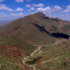
The location sits at higher elevation, which influences the climate and seasons throughout the year. Visitors should consider the terrain and weather when exploring the area.

The community maintains 9,231 residential mailboxes and 243 business mailboxes, supporting communication for over 218 local enterprises.

The community of curious travelers

AroundUs brings together thousands of curated places, local tips, and hidden gems, enriched daily by 60,000 contributors worldwide.

Start exploring
Location
Elevation above the sea
1,232 m
GPS coordinates
32.03920,-106.43000
Latest update
December 8, 2025 13:43
Around this place
Star on the Mountain
United States of America

Star on the Mountain

28.6 km
Sun Bowl Stadium
United States of America

Sun Bowl Stadium

30.5 km
Bridge of the Americas
Mexico

Bridge of the Americas

30.6 km
El Paso High School
United States of America

El Paso High School

30.2 km
Franklin Mountains State Park
United States of America

Franklin Mountains State Park

18.6 km
Chamizal National Memorial
United States of America

Chamizal National Memorial

30.3 km
Western Playland
United States of America

Western Playland

29 km
El Paso Zoo
United States of America

El Paso Zoo

30.1 km
North Franklin Mountain
United States of America

North Franklin Mountain

16.3 km
Wet N' Wild Waterworld
United States of America

Wet N' Wild Waterworld

15.6 km
Cohen Stadium
United States of America

Cohen Stadium

16.5 km
National Border Patrol Museum
United States of America

National Border Patrol Museum

15.2 km
O. T. Bassett Tower
United States of America

O. T. Bassett Tower

21.2 km
El Paso BOTA Port of Entry
United States of America

El Paso BOTA Port of Entry

30.3 km
Centennial Museum and Chihuahuan Desert Gardens
United States of America

Centennial Museum and Chihuahuan Desert Gardens

30.9 km
United States of America

El Paso Holocaust Museum and Study Center

31.4 km
El Paso Museum of Archaeology
United States of America

El Paso Museum of Archaeology

15.2 km
International Boundary Marker No. 1, U.S. and Mexico
Mexico

International Boundary Marker No. 1, U.S. and Mexico

29.9 km
Woman's Club of El Paso
United States of America

Woman's Club of El Paso

30.9 km
Fort Bliss Main Post Historic District
United States of America

Fort Bliss Main Post Historic District

25.8 km
Adventure Zone
United States of America

Adventure Zone

24.2 km
International Museum of Art
United States of America

International Museum of Art

30.3 km
San Jose Church
United States of America

San Jose Church

27.5 km
Montana Avenue Historic District
United States of America

Montana Avenue Historic District

30.1 km
Chope's Town Cafe and Bar
United States of America

Chope's Town Cafe and Bar

27.5 km
Museo Casa de Adobe
Mexico

Museo Casa de Adobe

30 km
Frank and Amelia Jones House
United States of America

Frank and Amelia Jones House

29.5 km
Lost Kingdom Water Park
United States of America

Lost Kingdom Water Park

27.8 km
Show the full map
Reviews
Share your experience

No review yet

Discussions
Start a discussion...

No discussion yet

« Chaparral - Census-designated place in Doña Ana County, New Mexico » is provided by Around Us (aroundus.com). Images and texts are derived from Wikimedia project under a Creative Commons license. You are allowed to copy, distribute, and modify copies of this page, under the conditions set by the license, as long as this note is clearly visible.

Discover hidden gems everywhere you go!

From secret cafés to breathtaking viewpoints, skip the crowded tourist spots and find places that match your style. Our app makes it easy with voice search, smart filtering, route optimization, and insider tips from travelers worldwide. Download now for the complete mobile experience.

Around Us App Screenshot

A unique approach to discovering new places

Le Figaro

All the places worth exploring

France Info

A tailor-made excursion in just a few clicks

20 Minutes

Around Us
Travel Guide & Maps
Download

Send to your phone

QR Code
1

Open the camera app on your mobile.

2

Point at the QR code with your camera. A notification will appear.

3

Tap the notification to open the link.