Enable Location

We need your location to show you interesting places around you

Discover nearby places

Find interesting locations and hidden gems around you

Precise directions

Get accurate directions and distances to places

Your location is never shared with other users. It's only used when you tap the location button.

Gateway to the Americas International Bridge

Log in to your account

Start exploring — it's free

Trusted by 62,097 travelers worldwide

Continue with Google
Continue with Apple
or

We will send you a code to connect

By continuing, you accept our Terms and Conditions and our Privacy Policy

Check your inbox

We've sent a pincode in your inbox. Please enter the code below.

Gateway to the Americas International Bridge

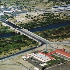
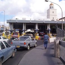
Gateway to the Americas International Bridge, International toll bridge between Laredo, Texas and Nuevo Laredo, Tamaulipas, Mexico

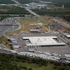
Gateway to the Americas is an international road bridge that spans the Rio Grande between Laredo and Nuevo Laredo, with four traffic lanes and two pedestrian walkways. The structure was designed to handle modern border traffic and processes thousands of crossings daily.

The site has connected both sides of the border since 1889, but the current bridge opened in 1954 after earlier versions were damaged by floods. This rebuilding provided a more stable and adequately sized connection for increasing border traffic.

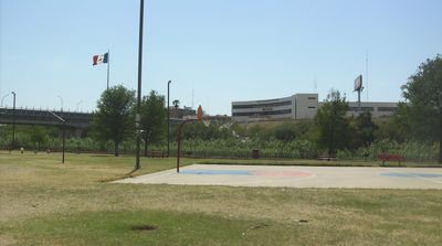
The bridge links two cities with strong economic ties, enabling daily interactions between residents on both sides of the border. Workers, traders, and families use this crossing as part of their everyday routine.

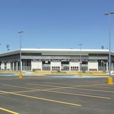
Pedestrians can cross the bridge 24 hours a day, while vehicles typically must be part of the SENTRI program and pay varying fees. Visitors should note that operating times vary for different access types and check current conditions before visiting.

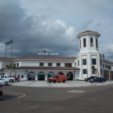
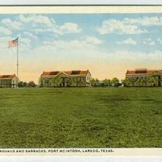
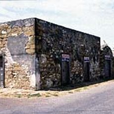
The U.S. inspection facility, built in 1943, was added to the National Register of Historic Places in 1992. This site is a rare example of border infrastructure recognized as a historical landmark.

The community of curious travelers

AroundUs brings together thousands of curated places, local tips, and hidden gems, enriched daily by 60,000 contributors worldwide.

Start exploring
Location
Location
Inception
1954
Official opening
1954
Length
264 m
Part of
Mexico–United States border
GPS coordinates
27.49940,-99.50740
Latest update
December 8, 2025 20:02
Around this place
Colombia – Solidarity International Bridge
Mexico

Colombia – Solidarity International Bridge

32.4 km
Falcon International Reservoir
Mexico

Falcon International Reservoir

110.1 km
Uni-Trade Stadium
United States of America

Uni-Trade Stadium

8.3 km
World Trade International Bridge
Mexico

World Trade International Bridge

11.3 km
Laredo Energy Arena
United States of America

Laredo Energy Arena

8.5 km
Fort McIntosh
United States of America

Fort McIntosh

1.5 km
Grutas de Bustamante
Mexico

Grutas de Bustamante

150.3 km
Texas Mexican Railway International Bridge
Mexico

Texas Mexican Railway International Bridge

887 m
Cathedral of San Agustin
United States of America

Cathedral of San Agustin

424 m
Estadio Nuevo Laredo
Mexico

Estadio Nuevo Laredo

8.6 km
Parque la Junta
Mexico

Parque la Junta

2.9 km
Student Activity Complex
United States of America

Student Activity Complex

6.9 km
Laredo Convent Avenue Port of Entry
United States of America

Laredo Convent Avenue Port of Entry

223 m
Roma Historic District
United States of America

Roma Historic District

131 km
Republic of the Rio Grande Museum
United States of America

Republic of the Rio Grande Museum

332 m
Asher and Mary Isabelle Richardson House
United States of America

Asher and Mary Isabelle Richardson House

107.9 km
Laredo United States Post Office, Court House and Custom House
United States of America

Laredo United States Post Office, Court House and Custom House

813 m
Webb County Courthouse
United States of America

Webb County Courthouse

915 m
Trevino-Uribe Rancho
United States of America

Trevino-Uribe Rancho

51 km
Herff-Rozelle Farm
United States of America

Herff-Rozelle Farm

84.3 km
Brooks County Courthouse
United States of America

Brooks County Courthouse

138.2 km
Estación Del Tren
Mexico

Estación Del Tren

144.7 km
La Salle County Courthouse
United States of America

La Salle County Courthouse

107.6 km
Popeye statue in Crystal City
United States of America

Popeye statue in Crystal City

135.2 km
Plaza Theater
United States of America

Plaza Theater

667 m
Regal Laredo Stadium 14
United States of America

Regal Laredo Stadium 14

8.7 km
Tivoli Theatre
United States of America

Tivoli Theatre

584 m
Garmon Theater
United States of America

Garmon Theater

142.3 km
Show the full map
« Gateway to the Americas International Bridge - International toll bridge between Laredo, Texas and Nuevo Laredo, Tamaulipas, Mexico » is provided by Around Us (aroundus.com). Images and texts are derived from Wikimedia project under a Creative Commons license. You are allowed to copy, distribute, and modify copies of this page, under the conditions set by the license, as long as this note is clearly visible.

Discover hidden gems everywhere you go!

From secret cafés to breathtaking viewpoints, skip the crowded tourist spots and find places that match your style. Our app makes it easy with voice search, smart filtering, route optimization, and insider tips from travelers worldwide. Download now for the complete mobile experience.

Around Us App Screenshot

A unique approach to discovering new places

Le Figaro

All the places worth exploring

France Info

A tailor-made excursion in just a few clicks

20 Minutes

Around Us
Travel Guide & Maps
Download

Send to your phone

QR Code
1

Open the camera app on your mobile.

2

Point at the QR code with your camera. A notification will appear.

3

Tap the notification to open the link.