Enable Location

We need your location to show you interesting places around you

Discover nearby places

Find interesting locations and hidden gems around you

Precise directions

Get accurate directions and distances to places

Your location is never shared with other users. It's only used when you tap the location button.

Colombia – Solidarity International Bridge

Log in to your account

Join the adventure

Create your free account and start exploring (like 60k+ others)

We will send you a code to connect

or
Continue with Google
Continue with Apple
By continuing, you accept our Terms and Conditions and our Privacy Policy

Check your inbox

We've sent a pincode in your inbox. Please enter the code below.

Colombia – Solidarity International Bridge

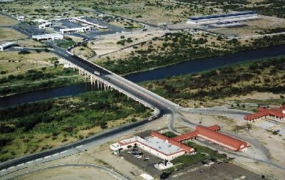
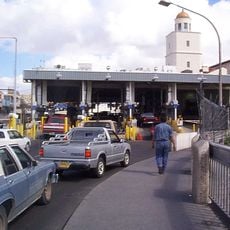
Colombia – Solidarity International Bridge, Road bridge and toll facility in Laredo, United States.

Description

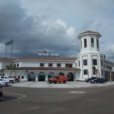
The Colombia – Solidarity International Bridge crosses the Rio Grande and links Laredo in Texas with the town of Colombia in the Mexican state of Nuevo León. The structure has separate lanes for trucks and passenger vehicles, with inspection stations and customs facilities on both banks.

History

The bridge opened in 1992 to ease traffic at other crossings in downtown Laredo. The structure was built during a period of growing trade between Texas and northern Mexico after the North American free trade agreement.

Culture

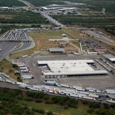
The crossing connects two communities woven together by trade and family ties on both sides of the Rio Grande. Trucks deliver goods between Texan and Mexican warehouses while commuters and visitors continue daily life across the border.

Practical

Trucks pass through the crossing every day of the week, while passenger vehicles may cross only from 8 AM until midnight. Waiting times depend on the hour and traffic volume, with early mornings often less crowded.

Did you know?

The bridge is the only crossing between Laredo in Texas and the Mexican state of Nuevo León. Drivers often wait in long queues on both sides while customs officers check documents and cargo.

Location
Inception
1992
Official opening
1992
Part of
Mexico–United States border
GPS coordinates
27.69972,-99.74565
Latest update
December 5, 2025 22:28

AroundUs brings together thousands of curated places, local tips, and hidden gems, enriched daily by 60,000 contributors worldwide. Discover all places nearby (Texas).

Around this place
Falcon International Reservoir
United States of America

Falcon International Reservoir

139.4 km
Uni-Trade Stadium
United States of America

Uni-Trade Stadium

33.1 km
World Trade International Bridge
United States of America

World Trade International Bridge

23.5 km
Gateway to the Americas International Bridge
Mexico

Gateway to the Americas International Bridge

32.4 km
Laredo Energy Arena
United States of America

Laredo Energy Arena

32.9 km
Fort Duncan
United States of America

Fort Duncan

134.1 km
Fort McIntosh
United States of America

Fort McIntosh

31 km
Eagle Pass – Piedras Negras International Bridge
Mexico

Eagle Pass – Piedras Negras International Bridge

134.9 km
Texas Mexican Railway International Bridge
Mexico

Texas Mexican Railway International Bridge

31.8 km
Cathedral of San Agustin
United States of America

Cathedral of San Agustin

32.3 km
Camino Real International Bridge
United States of America

Camino Real International Bridge

134.1 km
Estadio Nuevo Laredo
Mexico

Estadio Nuevo Laredo

28.8 km
Parque la Junta
Mexico

Parque la Junta

35.2 km
Student Activity Complex
United States of America

Student Activity Complex

37.8 km
Laredo Convent Avenue Port of Entry
United States of America

Laredo Convent Avenue Port of Entry

32.2 km
Republic of the Rio Grande Museum
United States of America

Republic of the Rio Grande Museum

32.3 km
Union Pacific International Railroad Bridge
Mexico

Union Pacific International Railroad Bridge

133.9 km
Martyrs of Christ the King Cathedral, Piedras Negras
Mexico

Martyrs of Christ the King Cathedral, Piedras Negras

136.1 km
Asher and Mary Isabelle Richardson House
United States of America

Asher and Mary Isabelle Richardson House

82.6 km
Laredo United States Post Office, Court House and Custom House
United States of America

Laredo United States Post Office, Court House and Custom House

31.9 km
Webb County Courthouse
United States of America

Webb County Courthouse

31.9 km
Trevino-Uribe Rancho
United States of America

Trevino-Uribe Rancho

78.8 km
Herff-Rozelle Farm
United States of America

Herff-Rozelle Farm

101.8 km
La Salle County Courthouse
United States of America

La Salle County Courthouse

96 km
Popeye statue in Crystal City
United States of America

Popeye statue in Crystal City

109.5 km
Plaza Theater
United States of America

Plaza Theater

32 km
Aztec Theatre
United States of America

Aztec Theatre

134.6 km
Regal Laredo Stadium 14
United States of America

Regal Laredo Stadium 14

32.7 km
Show the full map
« Colombia – Solidarity International Bridge - Road bridge and toll facility in Laredo, United States » is provided by Around Us (aroundus.com). Images and texts are derived from Wikimedia project under a Creative Commons license. You are allowed to copy, distribute, and modify copies of this page, under the conditions set by the license, as long as this note is clearly visible.

Discover hidden gems everywhere you go!

From secret cafés to breathtaking viewpoints, skip the crowded tourist spots and find places that match your style. Our app makes it easy with voice search, smart filtering, route optimization, and insider tips from travelers worldwide. Download now for the complete mobile experience.

Around Us App Screenshot

A unique approach to discovering new places

Le Figaro

All the places worth exploring

France Info

A tailor-made excursion in just a few clicks

20 Minutes

Around Us
Travel Guide & Maps
Download

Send to your phone

QR Code
1

Open the camera app on your mobile.

2

Point at the QR code with your camera. A notification will appear.

3

Tap the notification to open the link.