Union Pacific International Railroad Bridge

Log in to your account

AroundUs is a community-driven map of interesting places, built by curious explorers like you. It grows with every review, story, and photo you share.
Connect to save your favorite spots, contribute locations, and create personalized routes.
Continue with Google
Continue with Apple
Continue with X
Continue with Facebook
Continue with email
By continuing, you accept our Terms and Conditions and our Privacy Policy
Create an account

Union Pacific International Railroad Bridge

Add to collection
Map
Suggest a change
Share

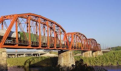
Union Pacific International Railroad Bridge, Railway bridge in Eagle Pass, Texas and Piedras Negras, Coahuila.

The Union Pacific International Railroad Bridge is a steel structure spanning the Rio Grande to connect Eagle Pass with Piedras Negras. The bridge comprises multiple steel deck sections supported by sturdy piers that carry freight trains over the river.

The bridge opened in 1999 as a key development in cross-border rail infrastructure between the United States and Mexico. This improvement enabled direct freight routes that integrated supply chains across the international boundary.

This rail crossing reveals the daily economic partnership between Texas and Coahuila through constant freight movement. The bridge embodies how trade shapes the relationship between these neighboring regions.

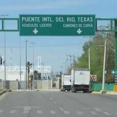
Access to the bridge is typically limited to railroad employees and authorized personnel, as this is not a public pedestrian crossing. The best viewing point is from the riverbank on either the Mexican or American side, where the full structure is visible.

Dozens of freight trains use the bridge daily, yet most visitors do not notice how railroad operators carefully manage train speed when crossing the river. Each train is closely monitored to ensure safety on this critical route.

Location: Texas

Location: Coahuila

Part of: Mexico–United States border

GPS coordinates: 28.69640,-100.51000

Latest update: December 14, 2025 14:44

Photos
Around this place
Garner State Park
United States of America

Garner State Park

124 km
Colombia – Solidarity International Bridge
Mexico

Colombia – Solidarity International Bridge

133.9 km
Amistad Reservoir
Mexico

Amistad Reservoir

99.4 km
Fort Clark
United States of America

Fort Clark

68.4 km
Sleeping Spring Draw
United States of America

Sleeping Spring Draw

66.7 km
Seminole Canyon State Park and Historic Site
United States of America

Seminole Canyon State Park and Historic Site

135 km
Amistad National Recreation Area
United States of America

Amistad National Recreation Area

97.7 km
Fort Inge
United States of America

Fort Inge

90.3 km
Fort Duncan
United States of America

Fort Duncan

727 m
Eagle Pass – Piedras Negras International Bridge
Mexico

Eagle Pass – Piedras Negras International Bridge

1 km
John Nance Garner House
United States of America

John Nance Garner House

90.5 km
Del Río – Ciudad Acuña International Bridge
Mexico

Del Río – Ciudad Acuña International Bridge

81.1 km
Lake Amistad Dam International Crossing
United States of America

Lake Amistad Dam International Crossing

99.4 km
Camino Real International Bridge
United States of America

Camino Real International Bridge

163 m
Whitehead Memorial Museum
United States of America

Whitehead Memorial Museum

82.1 km
Grand Opera House
United States of America

Grand Opera House

90.8 km
Mexico

Rio San Rodrigo

25.8 km
Martyrs of Christ the King Cathedral, Piedras Negras
Mexico

Martyrs of Christ the King Cathedral, Piedras Negras

5.3 km
Asher and Mary Isabelle Richardson House
United States of America

Asher and Mary Isabelle Richardson House

78.4 km
Fate Bell Shelter
United States of America

Fate Bell Shelter

136.2 km
State Highway 3 Bridge at the Nueces River
United States of America

State Highway 3 Bridge at the Nueces River

82 km
Lower Pecos Canyonlands Archeological District
United States of America

Lower Pecos Canyonlands Archeological District

136.2 km
Uvalde Downtown Historic District
United States of America

Uvalde Downtown Historic District

90.7 km
La Salle County Courthouse
United States of America

La Salle County Courthouse

127.8 km
Popeye statue in Crystal City
United States of America

Popeye statue in Crystal City

66.5 km
St. Philip's Episcopal Church
United States of America

St. Philip's Episcopal Church

90.9 km
Aztec Theatre
United States of America

Aztec Theatre

1.5 km
Combination Building
United States of America

Combination Building

124.4 km
Show the full map
Reviews

Visited this place? Tap the stars to rate it and share your experience / photos with the community! Try now! You can cancel it anytime.

« Union Pacific International Railroad Bridge - Railway bridge in Eagle Pass, Texas and Piedras Negras, Coahuila » is provided by Around Us (aroundus.com). Images and texts are derived from Wikimedia project under a Creative Commons license. You are allowed to copy, distribute, and modify copies of this page, under the conditions set by the license, as long as this note is clearly visible.

Discover hidden gems everywhere you go!

From secret cafés to breathtaking viewpoints, skip the crowded tourist spots and find places that match your style. Our app makes it easy with voice search, smart filtering, route optimization, and insider tips from travelers worldwide. Download now for the complete mobile experience.

Around Us App Screenshot

A unique approach to discovering new places

Le Figaro

All the places worth exploring

France Info

A tailor-made excursion in just a few clicks

20 Minutes