Enable Location

We need your location to show you interesting places around you

Discover nearby places

Find interesting locations and hidden gems around you

Precise directions

Get accurate directions and distances to places

Your location is never shared with other users. It's only used when you tap the location button.

Del Río – Ciudad Acuña International Bridge

Log in to your account

Start exploring — it's free

Trusted by 64,082 travelers worldwide

Continue with Google
Continue with Apple
or

We will send you a code to connect

By continuing, you accept our Terms and Conditions and our Privacy Policy

Check your inbox

We've sent a pincode in your inbox. Please enter the code below.

Del Río – Ciudad Acuña International Bridge
Discussion Reviews 1 Photos
3.1k Popularity

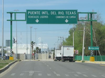
Del Río – Ciudad Acuña International Bridge, International toll bridge between Del Río, Texas and Ciudad Acuña, Mexico.

The Del Río-Ciudad Acuña International Bridge is a four-lane road bridge that spans approximately 620 meters across the Rio Grande River. It features two separate pedestrian walkways and serves vehicles and foot traffic crossing between Texas and Coahuila.

The bridge was built in 1930 as an early connection between the two towns. In 1987, it underwent major reconstruction to handle increased traffic and strengthen its structure.

The bridge serves as a daily crossing point where neighbors from both sides interact and share local goods and information. The area around it thrives on this constant human exchange between communities.

Crossing the border requires valid identification documents, and fees vary depending on whether you are walking or driving a vehicle. It is wise to check current requirements beforehand and allow extra time for processing.

In 2021, the area beneath the bridge temporarily sheltered thousands of migrants seeking entry into the United States. This event highlighted the bridge's role in regional migration dynamics.

The community of curious travelers

AroundUs brings together thousands of curated places, local tips, and hidden gems, enriched daily by 60,000 contributors worldwide.

Start exploring
Location
Location
Official opening
1930
Part of
Mexico–United States border
GPS coordinates
29.32676,-100.92751
Latest update
December 12, 2025 12:01
Around this place
Amistad Reservoir
Mexico

Amistad Reservoir

18.7 km
Fort Clark
United States of America

Fort Clark

49.3 km
Sleeping Spring Draw
United States of America

Sleeping Spring Draw

77.2 km
Pecos River High Bridge
United States of America

Pecos River High Bridge

63.6 km
Seminole Canyon State Park and Historic Site
United States of America

Seminole Canyon State Park and Historic Site

54.8 km
Amistad National Recreation Area
United States of America

Amistad National Recreation Area

17.1 km
Fort Inge
United States of America

Fort Inge

114.1 km
Fort Duncan
United States of America

Fort Duncan

80.8 km
Eagle Pass – Piedras Negras International Bridge
Mexico

Eagle Pass – Piedras Negras International Bridge

80.1 km
John Nance Garner House
United States of America

John Nance Garner House

111 km
Lake Amistad Dam International Crossing
United States of America

Lake Amistad Dam International Crossing

18.7 km
Camino Real International Bridge
United States of America

Camino Real International Bridge

80.9 km
Whitehead Memorial Museum
United States of America

Whitehead Memorial Museum

4 km
Mile Canyon
United States of America

Mile Canyon

81.2 km
Grand Opera House
United States of America

Grand Opera House

111.5 km
Mexico

Rio San Rodrigo

55.3 km
Martyrs of Christ the King Cathedral, Piedras Negras
Mexico

Martyrs of Christ the King Cathedral, Piedras Negras

79.5 km
Edwards County Courthouse and Jail
United States of America

Edwards County Courthouse and Jail

103.6 km
Pecos River Bridge
United States of America

Pecos River Bridge

59.1 km
Fate Bell Shelter
United States of America

Fate Bell Shelter

55.8 km
State Highway 3 Bridge at the Nueces River
United States of America

State Highway 3 Bridge at the Nueces River

100.5 km
Lower Pecos Canyonlands Archeological District
United States of America

Lower Pecos Canyonlands Archeological District

55.8 km
Uvalde Downtown Historic District
United States of America

Uvalde Downtown Historic District

111.5 km
Seminole Canyon District
United States of America

Seminole Canyon District

55.8 km
St. Philip's Episcopal Church
United States of America

St. Philip's Episcopal Church

111.3 km
Aztec Theatre
United States of America

Aztec Theatre

80.3 km
Pecos River Boat Dock
United States of America

Pecos River Boat Dock

59.4 km
Nicolas Street School
United States of America

Nicolas Street School

111 km
Show the full map
Reviews
Share your experience

No review yet

Discussions
Start a discussion...

No discussion yet

« Del Río – Ciudad Acuña International Bridge - International toll bridge between Del Río, Texas and Ciudad Acuña, Mexico » is provided by Around Us (aroundus.com). Images and texts are derived from Wikimedia project under a Creative Commons license. You are allowed to copy, distribute, and modify copies of this page, under the conditions set by the license, as long as this note is clearly visible.

Discover hidden gems everywhere you go!

From secret cafés to breathtaking viewpoints, skip the crowded tourist spots and find places that match your style. Our app makes it easy with voice search, smart filtering, route optimization, and insider tips from travelers worldwide. Download now for the complete mobile experience.

Around Us App Screenshot

A unique approach to discovering new places

Le Figaro

All the places worth exploring

France Info

A tailor-made excursion in just a few clicks

20 Minutes

Around Us
Travel Guide & Maps
Download

Send to your phone

QR Code
1

Open the camera app on your mobile.

2

Point at the QR code with your camera. A notification will appear.

3

Tap the notification to open the link.