Enable Location

We need your location to show you interesting places around you

Discover nearby places

Find interesting locations and hidden gems around you

Precise directions

Get accurate directions and distances to places

Your location is never shared with other users. It's only used when you tap the location button.

Pecos River High Bridge

Log in to your account

Start exploring — it's free

Trusted by 62,062 travelers worldwide

Continue with Google
Continue with Apple
or

We will send you a code to connect

By continuing, you accept our Terms and Conditions and our Privacy Policy

Check your inbox

We've sent a pincode in your inbox. Please enter the code below.

Pecos River High Bridge

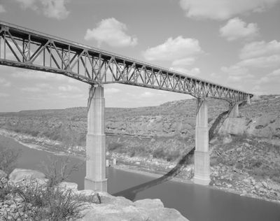
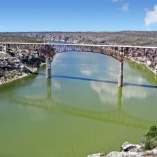
Pecos River High Bridge, Railway bridge over Pecos River in Val Verde County, United States

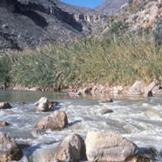
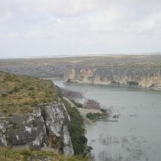
The Pecos River High Bridge is a steel truss structure that spans the gorge of the Pecos River using seven main sections and two piers positioned in the water below. The bridge carries freight and passenger trains daily between the towns of Sanderson and Del Rio across the canyon landscape.

The bridge was designed by engineers Modjeski and Masters during World War II and completed in 1944 despite severe material shortages. Its construction was driven by the need to reinforce rail connections across the region during wartime.

The bridge forms part of the Historic American Engineering Record, documenting the advancement of railroad infrastructure development in the southwestern United States.

The bridge can be viewed from nearby highways and offers impressive views of the river landscape below. Since this is an active railroad structure, visitor access may be limited to safe vantage points away from train traffic.

Before construction could begin, the project required special approval from the War Production Board due to steel shortages during the conflict. This makes it a rare example of a major engineering project that was completed despite wartime economic constraints.

The community of curious travelers

AroundUs brings together thousands of curated places, local tips, and hidden gems, enriched daily by 60,000 contributors worldwide.

Start exploring
Location
Inception
1943
Height
98 m
Length
424 m
Made from material
steel
GPS coordinates
29.75849,-101.35743
Latest update
December 8, 2025 20:02
Around this place
Amistad Reservoir
Mexico

Amistad Reservoir

44.9 km
Fort Clark
United States of America

Fort Clark

103.8 km
Sleeping Spring Draw
United States of America

Sleeping Spring Draw

132.7 km
Seminole Canyon State Park and Historic Site
United States of America

Seminole Canyon State Park and Historic Site

9.2 km
Amistad National Recreation Area
United States of America

Amistad National Recreation Area

46.6 km
Fort Duncan
United States of America

Fort Duncan

143.9 km
Fort Lancaster
United States of America

Fort Lancaster

106.2 km
Rio Grande Wild and Scenic River
United States of America

Rio Grande Wild and Scenic River

113.2 km
Eagle Pass – Piedras Negras International Bridge
Mexico

Eagle Pass – Piedras Negras International Bridge

143.1 km
Del Río – Ciudad Acuña International Bridge
Mexico

Del Río – Ciudad Acuña International Bridge

63.6 km
Lake Amistad Dam International Crossing
United States of America

Lake Amistad Dam International Crossing

44.9 km
Camino Real International Bridge
United States of America

Camino Real International Bridge

143.9 km
Whitehead Memorial Museum
United States of America

Whitehead Memorial Museum

63.5 km
Mile Canyon
United States of America

Mile Canyon

19.7 km
Canon Ranch Railroad Eclipse Windmill
United States of America

Canon Ranch Railroad Eclipse Windmill

124.9 km
Mexico

Rio San Rodrigo

118.5 km
Martyrs of Christ the King Cathedral, Piedras Negras
Mexico

Martyrs of Christ the King Cathedral, Piedras Negras

142 km
Crockett County Courthouse
United States of America

Crockett County Courthouse

107.1 km
Edwards County Courthouse and Jail
United States of America

Edwards County Courthouse and Jail

114.6 km
Sutton County Courthouse
United States of America

Sutton County Courthouse

113.7 km
Pecos River Bridge
United States of America

Pecos River Bridge

5.6 km
Fate Bell Shelter
United States of America

Fate Bell Shelter

7.9 km
Lower Pecos Canyonlands Archeological District
United States of America

Lower Pecos Canyonlands Archeological District

7.9 km
Seminole Canyon District
United States of America

Seminole Canyon District

7.9 km
Fort Lancaster State Historic Site
United States of America

Fort Lancaster State Historic Site

106.1 km
Aztec Theatre
United States of America

Aztec Theatre

143.4 km
Princess Theater
United States of America

Princess Theater

108.8 km
Pecos River Boat Dock
United States of America

Pecos River Boat Dock

6 km
Show the full map
« Pecos River High Bridge - Railway bridge over Pecos River in Val Verde County, United States » is provided by Around Us (aroundus.com). Images and texts are derived from Wikimedia project under a Creative Commons license. You are allowed to copy, distribute, and modify copies of this page, under the conditions set by the license, as long as this note is clearly visible.

Discover hidden gems everywhere you go!

From secret cafés to breathtaking viewpoints, skip the crowded tourist spots and find places that match your style. Our app makes it easy with voice search, smart filtering, route optimization, and insider tips from travelers worldwide. Download now for the complete mobile experience.

Around Us App Screenshot

A unique approach to discovering new places

Le Figaro

All the places worth exploring

France Info

A tailor-made excursion in just a few clicks

20 Minutes

Around Us
Travel Guide & Maps
Download

Send to your phone

QR Code
1

Open the camera app on your mobile.

2

Point at the QR code with your camera. A notification will appear.

3

Tap the notification to open the link.