Enable Location

We need your location to show you interesting places around you

Discover nearby places

Find interesting locations and hidden gems around you

Precise directions

Get accurate directions and distances to places

Your location is never shared with other users. It's only used when you tap the location button.

Amistad Reservoir

Log in to your account

Start exploring — it's free

Trusted by 62,067 travelers worldwide

Continue with Google
Continue with Apple
or

We will send you a code to connect

By continuing, you accept our Terms and Conditions and our Privacy Policy

Check your inbox

We've sent a pincode in your inbox. Please enter the code below.

Amistad Reservoir

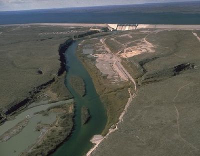
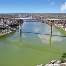
Amistad Reservoir, International reservoir in Val Verde County, United States and Coahuila, Mexico

Amistad Reservoir is a body of water on the border between Val Verde County in the United States and Acuña Municipality in Mexico, spreading over the Rio Grande where it meets the Devils River. The lake covers roughly 330 square kilometers (about 127 square miles) at full capacity and holds nearly 4,000 cubic kilometers of water, with slightly more than half allocated to the United States and the remainder to Mexico.

The dam construction started in December 1964 following a treaty between the United States and Mexico from 1944 about sharing the Rio Grande water. The project was completed in November 1969 and the reservoir began filling immediately afterward.

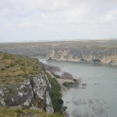
The name comes from the Spanish word for friendship and recalls the shared management of water resources by both countries. Visitors today see boat ramps and recreation areas on both sides of the border, used by locals from Texas and Coahuila alike.

Access to the water is available from both countries, with visitors needing to respect different border regulations depending on which side they choose. Water levels vary by season and rainfall, so it helps to check ahead if boat ramps and shoreline areas are accessible.

The filling of the lake in 1969 flooded the natural habitat of a small fish species called Amistad gambusia, which lived only in this area. The species disappeared completely by 1987 and is now considered extinct.

The community of curious travelers

AroundUs brings together thousands of curated places, local tips, and hidden gems, enriched daily by 60,000 contributors worldwide.

Start exploring
Location
Inception
1969
GPS coordinates
29.45028,-101.05778
Latest update
December 5, 2025 22:31
Around this place
Garner State Park
United States of America

Garner State Park

128.6 km
Fort Clark
United States of America

Fort Clark

63.9 km
Sleeping Spring Draw
United States of America

Sleeping Spring Draw

92.7 km
Pecos River High Bridge
United States of America

Pecos River High Bridge

44.9 km
Seminole Canyon State Park and Historic Site
United States of America

Seminole Canyon State Park and Historic Site

36.2 km
Amistad National Recreation Area
United States of America

Amistad National Recreation Area

1.7 km
Fort Duncan
United States of America

Fort Duncan

99.2 km
Eagle Pass – Piedras Negras International Bridge
Mexico

Eagle Pass – Piedras Negras International Bridge

98.5 km
John Nance Garner House
United States of America

John Nance Garner House

125.6 km
Del Río – Ciudad Acuña International Bridge
Mexico

Del Río – Ciudad Acuña International Bridge

18.7 km
Lake Amistad Dam International Crossing
United States of America

Lake Amistad Dam International Crossing

82 m
Camino Real International Bridge
United States of America

Camino Real International Bridge

99.3 km
Whitehead Memorial Museum
United States of America

Whitehead Memorial Museum

19 km
Mile Canyon
United States of America

Mile Canyon

62.7 km
Grand Opera House
United States of America

Grand Opera House

126.2 km
Mexico

Rio San Rodrigo

73.7 km
Union Pacific International Railroad Bridge
Mexico

Union Pacific International Railroad Bridge

99.4 km
Martyrs of Christ the King Cathedral, Piedras Negras
Mexico

Martyrs of Christ the King Cathedral, Piedras Negras

97.6 km
Edwards County Courthouse and Jail
United States of America

Edwards County Courthouse and Jail

103.5 km
Pecos River Bridge
United States of America

Pecos River Bridge

40.5 km
Fate Bell Shelter
United States of America

Fate Bell Shelter

37.1 km
State Highway 3 Bridge at the Nueces River
United States of America

State Highway 3 Bridge at the Nueces River

115.4 km
Lower Pecos Canyonlands Archeological District
United States of America

Lower Pecos Canyonlands Archeological District

37.1 km
Uvalde Downtown Historic District
United States of America

Uvalde Downtown Historic District

126.2 km
Seminole Canyon District
United States of America

Seminole Canyon District

37.1 km
St. Philip's Episcopal Church
United States of America

St. Philip's Episcopal Church

126 km
Aztec Theatre
United States of America

Aztec Theatre

98.7 km
Pecos River Boat Dock
United States of America

Pecos River Boat Dock

40.7 km
Show the full map
« Amistad Reservoir - International reservoir in Val Verde County, United States and Coahuila, Mexico » is provided by Around Us (aroundus.com). Images and texts are derived from Wikimedia project under a Creative Commons license. You are allowed to copy, distribute, and modify copies of this page, under the conditions set by the license, as long as this note is clearly visible.

Discover hidden gems everywhere you go!

From secret cafés to breathtaking viewpoints, skip the crowded tourist spots and find places that match your style. Our app makes it easy with voice search, smart filtering, route optimization, and insider tips from travelers worldwide. Download now for the complete mobile experience.

Around Us App Screenshot

A unique approach to discovering new places

Le Figaro

All the places worth exploring

France Info

A tailor-made excursion in just a few clicks

20 Minutes

Around Us
Travel Guide & Maps
Download

Send to your phone

QR Code
1

Open the camera app on your mobile.

2

Point at the QR code with your camera. A notification will appear.

3

Tap the notification to open the link.