Enable Location

We need your location to show you interesting places around you

Discover nearby places

Find interesting locations and hidden gems around you

Precise directions

Get accurate directions and distances to places

Your location is never shared with other users. It's only used when you tap the location button.

Unmanned reef lights of the Florida Keys

Log in to your account

Start exploring — it's free

Trusted by 65,638 travelers worldwide

Continue with Google
Continue with Apple
or

We will send you a code to connect

By continuing, you accept our Terms and Conditions and our Privacy Policy

Check your inbox

We've sent a pincode in your inbox. Please enter the code below.

Unmanned reef lights of the Florida Keys
Discussion Reviews 1 Photos
3.7k Popularity

Unmanned reef lights of the Florida Keys, Navigational beacons in Florida Keys, United States.

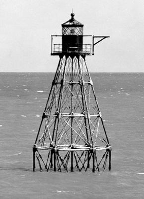
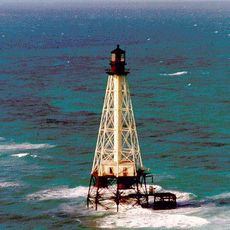
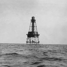
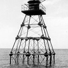
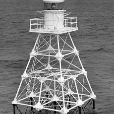
The Unmanned Reef Lights of the Florida Keys are automated navigation towers built on screw-pile foundations in the shallow waters and reefs of the Keys. They mark submerged hazards and guide vessels through the channels and reef passages of this stretch of coastline.

The first of these towers was built in 1921, with more added through 1935 to handle growing maritime traffic in the region. They were a direct response to the frequent shipwrecks that had long made these waters dangerous.

The towers are a familiar sight for anyone traveling by boat through the Keys and are seen as landmarks of these waterways. Fishermen and sailors still use them as reference points, even though modern navigation tools are now common.

The towers stand on remote reefs and are not open to the public, so the best way to see them is from a boat or with binoculars from a distance. Many serve as nesting sites for birds, so keeping a respectful distance is always a good idea.

Each tower was given a distinct geometric shape, such as square, triangular, or hexagonal, so that captains could identify different reefs by shape alone. This system was standardized by 1932 and worked as a kind of visual alphabet for navigating these waters.

The community of curious travelers

AroundUs brings together thousands of curated places, local tips, and hidden gems, enriched daily by 60,000 contributors worldwide.

Start exploring
Location
GPS coordinates
25.01667,-80.38333
Latest update
March 3, 2026 14:01
Around this place
Everglades National Park
United States of America

Everglades National Park

45 km
Homestead-Miami Speedway
United States of America

Homestead-Miami Speedway

48.5 km
Aquarius Reef Base
United States of America

Aquarius Reef Base

10.3 km
United States of America

Florida Reef

9.4 km
John Pennekamp Coral Reef State Park
United States of America

John Pennekamp Coral Reef State Park

11.8 km
African Queen
United States of America

African Queen

10.4 km
Alligator Reef Light
United States of America

Alligator Reef Light

30 km
Card Sound Bridge
United States of America

Card Sound Bridge

30.2 km
Crocodile Lake National Wildlife Refuge
United States of America

Crocodile Lake National Wildlife Refuge

29 km
Everglades Alligator Farm
United States of America

Everglades Alligator Farm

43.6 km
Theater of the Sea
United States of America

Theater of the Sea

23.6 km
Indian Key State Historic Site
United States of America

Indian Key State Historic Site

34.5 km
Anhinga Trail
United States of America

Anhinga Trail

46.6 km
Carysfort Reef Light
United States of America

Carysfort Reef Light

28.7 km
Jewfish Creek Bridge
United States of America

Jewfish Creek Bridge

18.3 km
Dagny Johnson Key Largo Hammock Botanical State Park
United States of America

Dagny Johnson Key Largo Hammock Botanical State Park

17.8 km
Everglades & Dry Tortugas
United States of America

Everglades & Dry Tortugas

37 km
Snake Creek Bridge
United States of America

Snake Creek Bridge

21.8 km
Florida Pioneer Museum
United States of America

Florida Pioneer Museum

50 km
Jones Family Historic District
United States of America

Jones Family Historic District

44.3 km
Royal Palm
United States of America

Royal Palm

46.7 km
Molasses Reef Light
United States of America

Molasses Reef Light

898 m
Pacific Reef Light
United States of America

Pacific Reef Light

46.3 km
Hell's Bay Canoe Trail
United States of America

Hell's Bay Canoe Trail

50.4 km
Florida Keys Memorial
United States of America

Florida Keys Memorial

27.8 km
Ernest F. Coe Visitor Center‎
United States of America

Ernest F. Coe Visitor Center‎

46.7 km
Dante Fascell Visitor Center
United States of America

Dante Fascell Visitor Center

50.1 km
Everglades Homestead Entrance Station
United States of America

Everglades Homestead Entrance Station

46.9 km
Show the full map
Reviews
Share your experience

No review yet

Discussions
Start a discussion...

No discussion yet

« Unmanned reef lights of the Florida Keys - Navigational beacons in Florida Keys, United States » is provided by Around Us (aroundus.com). Images and texts are derived from Wikimedia project under a Creative Commons license. You are allowed to copy, distribute, and modify copies of this page, under the conditions set by the license, as long as this note is clearly visible.

Discover hidden gems everywhere you go!

From secret cafés to breathtaking viewpoints, skip the crowded tourist spots and find places that match your style. Our app makes it easy with voice search, smart filtering, route optimization, and insider tips from travelers worldwide. Download now for the complete mobile experience.

Around Us App Screenshot

A unique approach to discovering new places

Le Figaro

All the places worth exploring

France Info

A tailor-made excursion in just a few clicks

20 Minutes

Around Us
Travel Guide & Maps
Download

Send to your phone

QR Code
1

Open the camera app on your mobile.

2

Point at the QR code with your camera. A notification will appear.

3

Tap the notification to open the link.