Enable Location

We need your location to show you interesting places around you

Discover nearby places

Find interesting locations and hidden gems around you

Precise directions

Get accurate directions and distances to places

Your location is never shared with other users. It's only used when you tap the location button.

Oconee County

Log in to your account

Start exploring — it's free

Trusted by 63,212 travelers worldwide

Continue with Google
Continue with Apple
or

We will send you a code to connect

By continuing, you accept our Terms and Conditions and our Privacy Policy

Check your inbox

We've sent a pincode in your inbox. Please enter the code below.

Discussion Reviews 1 Photos
22k Popularity

Oconee County, Administrative division in northeast Georgia, United States

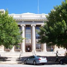
Oconee County is an administrative division in northeast Georgia with multiple departments managing public services and community development. The administrative center in Watkinsville provides essential government services and coordinates operations throughout the region.

The county was established in 1875 and represented a major administrative reorganization in Georgia. This founding created new governmental structures that shaped the region's development over time.

The administrative center serves as a gathering place where residents attend community meetings and local events together. Here you can see how neighbors engage with one another around shared civic concerns.

Residents and visitors can find the main administrative offices at Macon Highway in Watkinsville, which serves as the central hub for county services. This location is easy to reach and handles most government-related inquiries.

The Keep Oconee County Beautiful Commission runs environmental programs focused on systematic recycling and waste management across the region. These efforts reflect local commitment to sustainable practices in everyday life.

The community of curious travelers

AroundUs brings together thousands of curated places, local tips, and hidden gems, enriched daily by 60,000 contributors worldwide.

Start exploring
Location
Inception
February 24, 1875
Capital city
Watkinsville
Shares border with
Clarke County, Morgan County, Greene County, Oglethorpe County, Jackson County, Barrow County, Walton County
GPS coordinates
33.84000,-83.44000
Latest update
December 23, 2025 09:33
Around this place
Sanford Stadium
United States of America

Sanford Stadium

13.7 km
Stegeman Coliseum
United States of America

Stegeman Coliseum

12.8 km
Georgia Theatre
United States of America

Georgia Theatre

14.4 km
United States of America

Georgia Museum of Art

13 km
Athens Confederate Monument
United States of America

Athens Confederate Monument

9.3 km
Herty Field
United States of America

Herty Field

14.2 km
The State Botanical Garden of Georgia
United States of America

The State Botanical Garden of Georgia

8.8 km
Lucy Cobb Institute
United States of America

Lucy Cobb Institute

13.7 km
President's House
United States of America

President's House

14.6 km
United States of America

University of Georgia Campus Arboretum

13.9 km
Henry W. Grady House
United States of America

Henry W. Grady House

14.4 km
United States of America

Georgia Museum of Natural History

13.3 km
Franklin House
United States of America

Franklin House

14.4 km
Downtown Athens Historic District
United States of America

Downtown Athens Historic District

14.5 km
Camak House
United States of America

Camak House

14.2 km
Athens Regional Library System
United States of America

Athens Regional Library System

12.2 km
Epps 1907 Monoplane
United States of America

Epps 1907 Monoplane

14.5 km
Eagle Tavern
United States of America

Eagle Tavern

3.9 km
Richard B. Russell Library for Political Research and Studies
United States of America

Richard B. Russell Library for Political Research and Studies

14 km
UGA Carnegie Library
United States of America

UGA Carnegie Library

14.2 km
Joseph Henry Lumpkin House
United States of America

Joseph Henry Lumpkin House

14.4 km
Elder's Mill Covered Bridge and Elder Mill
United States of America

Elder's Mill Covered Bridge and Elder Mill

8.2 km
United States of America

South Main Street Historic District

3.6 km
Ware-Lyndon house
United States of America

Ware-Lyndon house

15 km
Clarke County Courthouse
United States of America

Clarke County Courthouse

14.5 km
United States of America

Wilkins House

13.3 km
United States of America

Bishop Historic District

2.4 km
Cobbham Historic District
United States of America

Cobbham Historic District

14 km
Show the full map
Reviews
Share your experience

No review yet

Discussions
Start a discussion...

No discussion yet

« Oconee County - Administrative division in northeast Georgia, United States » is provided by Around Us (aroundus.com). Images and texts are derived from Wikimedia project under a Creative Commons license. You are allowed to copy, distribute, and modify copies of this page, under the conditions set by the license, as long as this note is clearly visible.

Discover hidden gems everywhere you go!

From secret cafés to breathtaking viewpoints, skip the crowded tourist spots and find places that match your style. Our app makes it easy with voice search, smart filtering, route optimization, and insider tips from travelers worldwide. Download now for the complete mobile experience.

Around Us App Screenshot

A unique approach to discovering new places

Le Figaro

All the places worth exploring

France Info

A tailor-made excursion in just a few clicks

20 Minutes

Around Us
Travel Guide & Maps
Download

Send to your phone

QR Code
1

Open the camera app on your mobile.

2

Point at the QR code with your camera. A notification will appear.

3

Tap the notification to open the link.