Enable Location

We need your location to show you interesting places around you

Discover nearby places

Find interesting locations and hidden gems around you

Precise directions

Get accurate directions and distances to places

Your location is never shared with other users. It's only used when you tap the location button.

Palm Valley Bridge

Log in to your account

Start exploring — it's free

Trusted by 63,020 travelers worldwide

Continue with Google
Continue with Apple
or

We will send you a code to connect

By continuing, you accept our Terms and Conditions and our Privacy Policy

Check your inbox

We've sent a pincode in your inbox. Please enter the code below.

Palm Valley Bridge
Discussion Reviews 1 Photos
1.5k Popularity

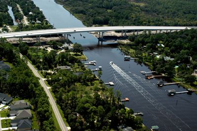
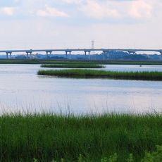
Palm Valley Bridge, Road bridge at Ponte Vedra Beach, Florida.

Palm Valley Bridge is a modern road bridge that crosses the Intracoastal Waterway with four traffic lanes, linking Palm Valley to surrounding communities. The structure was built as a fixed-span design that allows continuous vehicle passage without delays for water traffic.

The original structure built in 1937 was a drawbridge that was replaced in 2002 by the current fixed-span design to handle increased traffic and regional population growth. The replacement marked a major turning point in local transportation infrastructure.

The bridge represents a milestone in local infrastructure development, documented by the Historic American Engineering Record through extensive photographs and technical data.

The bridge is located on County Road 210 in St. Johns County and is easily accessible via this main route. Visitors should travel during morning or afternoon hours outside rush periods for the best driving experience.

This is the final bridge crossing the Intracoastal Waterway in Florida under direct management by the US Army Corps of Engineers. This unique jurisdiction makes it a distinctive point in the state's infrastructure.

The community of curious travelers

AroundUs brings together thousands of curated places, local tips, and hidden gems, enriched daily by 60,000 contributors worldwide.

Start exploring
Location
GPS coordinates
30.13290,-81.38560
Latest update
December 14, 2025 14:21
Around this place
Castillo de San Marcos
United States of America

Castillo de San Marcos

27.1 km
TPC Sawgrass
United States of America

TPC Sawgrass

7.1 km
World Golf Hall of Fame
United States of America

World Golf Hall of Fame

17.8 km
Fort Mose
United States of America

Fort Mose

23.6 km
Fountain of Youth Archaeological Park
United States of America

Fountain of Youth Archaeological Park

26 km
Hanna Park
United States of America

Hanna Park

27.1 km
Oldest Wooden Schoolhouse
United States of America

Oldest Wooden Schoolhouse

27.1 km
Old St. Johns County Jail
United States of America

Old St. Johns County Jail

25.9 km
Hodges Stadium
United States of America

Hodges Stadium

20 km
Freebird Live
United States of America

Freebird Live

17.6 km
Milam Residence
United States of America

Milam Residence

5.2 km
Castillo de San Marcos National Monument
United States of America

Castillo de San Marcos National Monument

27.2 km
121 Atlantic Place
United States of America

121 Atlantic Place

21.4 km
St. Augustine Aquarium
United States of America

St. Augustine Aquarium

24.4 km
Thomas G. Carpenter Library
United States of America

Thomas G. Carpenter Library

19.2 km
Abbott Tract Historic District
United States of America

Abbott Tract Historic District

26.7 km
Charles E. Bennett Memorial Bridge
United States of America

Charles E. Bennett Memorial Bridge

26 km
Nombre de Dios
United States of America

Nombre de Dios

26.2 km
Horace Walker House
United States of America

Horace Walker House

26.3 km
St. Augustine Civic Center
United States of America

St. Augustine Civic Center

27 km
Hands on Childrens Museum
United States of America

Hands on Childrens Museum

24.5 km
Dickinson Memorial Library and Park
United States of America

Dickinson Memorial Library and Park

22.2 km
St. Augustine Water Works
United States of America

St. Augustine Water Works

25.5 km
Nelmar Terrace Historic District
United States of America

Nelmar Terrace Historic District

25.6 km
Fort Mose Historic State Park
United States of America

Fort Mose Historic State Park

23.4 km
Fullerwood Park Residential Historic District
United States of America

Fullerwood Park Residential Historic District

24.9 km
North City Historic District
United States of America

North City Historic District

26.5 km
Regal Beach Boulevard 18
United States of America

Regal Beach Boulevard 18

18.4 km
Show the full map
Reviews
Share your experience

No review yet

Discussions
Start a discussion...

No discussion yet

« Palm Valley Bridge - Road bridge at Ponte Vedra Beach, Florida » is provided by Around Us (aroundus.com). Images and texts are derived from Wikimedia project under a Creative Commons license. You are allowed to copy, distribute, and modify copies of this page, under the conditions set by the license, as long as this note is clearly visible.

Discover hidden gems everywhere you go!

From secret cafés to breathtaking viewpoints, skip the crowded tourist spots and find places that match your style. Our app makes it easy with voice search, smart filtering, route optimization, and insider tips from travelers worldwide. Download now for the complete mobile experience.

Around Us App Screenshot

A unique approach to discovering new places

Le Figaro

All the places worth exploring

France Info

A tailor-made excursion in just a few clicks

20 Minutes

Around Us
Travel Guide & Maps
Download

Send to your phone

QR Code
1

Open the camera app on your mobile.

2

Point at the QR code with your camera. A notification will appear.

3

Tap the notification to open the link.