·

Enable Location

We need your location to show you interesting places around you

Discover nearby places

Find interesting locations and hidden gems around you

Precise directions

Get accurate directions and distances to places

Your location is never shared with other users. It's only used when you tap the location button.

Mulberry Plantation

Log in to your account

Start exploring — it's free

Trusted by 62,649 travelers worldwide

Continue with Google
Continue with Apple
or

We will send you a code to connect

By continuing, you accept our Terms and Conditions and our Privacy Policy

Check your inbox

We've sent a pincode in your inbox. Please enter the code below.

Mulberry Plantation, human settlement in South Carolina, United States of America

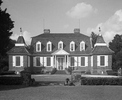
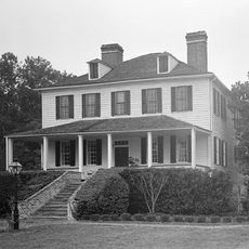
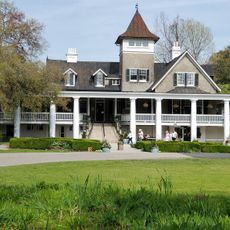
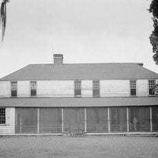
Mulberry Plantation is a brick house built in the early 1700s, standing on a small hill beside the Cooper River about three miles south of Moncks Corner. The building features a low, wide shape with a distinctive gambrel roof and four small brick pavilions with curved roofs attached to its sides.

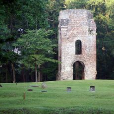
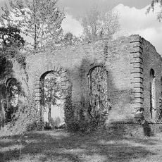
The estate was built around 1714 by Thomas Broughton, who later became the Royal Governor of South Carolina. The house originally served as a defensive site against attacks and functioned as a protective station during the Yamasee War.

The house reflects the architectural traditions of Huguenot settlers who established themselves in the Lowcountry region. Its distinctive form with steep gambrel roof and small gables shows how European building styles were adapted to local conditions by early colonists.

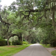
Visitors can explore the exterior of the house along with the surrounding fields and waterways. The thick brick walls and evenly spaced windows are visible from the outside, and educational information helps guests understand early American architecture and plantation life.

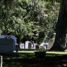
British artist Thomas Coram painted the estate around 1800, showing the house alongside rows of small slave houses. This historic image documents the layout and daily life on the plantation during that period.

The community of curious travelers

AroundUs brings together thousands of curated places, local tips, and hidden gems, enriched daily by 60,000 contributors worldwide.

Start exploring
Location
GPS coordinates
33.14190,-80.01780
Latest update
February 7, 2026 11:00
Around this place
Magnolia Plantation and Gardens
United States of America

Magnolia Plantation and Gardens

30.2 km
Drayton Hall
United States of America

Drayton Hall

30.7 km
Middleton Place
United States of America

Middleton Place

29 km
Mepkin Abbey
United States of America

Mepkin Abbey

6.9 km
Lewisfield Plantation
United States of America

Lewisfield Plantation

3 km
Magnolia Plantation
United States of America

Magnolia Plantation

30.2 km
Cypress Gardens
United States of America

Cypress Gardens

12.3 km
Edmondston-Alston House
United States of America

Edmondston-Alston House

27 km
Medway
United States of America

Medway

13.1 km
Colonial Dorchester State Historic Site
United States of America

Colonial Dorchester State Historic Site

25.8 km
Don N. Holt Bridge
United States of America

Don N. Holt Bridge

28.4 km
Middleburg Plantation
United States of America

Middleburg Plantation

17.6 km
South Carolina Highway 61
United States of America

South Carolina Highway 61

29.6 km
Cypress Gardens
United States of America

Cypress Gardens

11.6 km
Ashley River Historic District
United States of America

Ashley River Historic District

27.4 km
Biggin Church
United States of America

Biggin Church

9.2 km
Old White Meeting House Ruins and Cemetery
United States of America

Old White Meeting House Ruins and Cemetery

25.6 km
Gippy Plantation
United States of America

Gippy Plantation

3.5 km
Charleston Navy Yard Officers' Quarters Historic District
United States of America

Charleston Navy Yard Officers' Quarters Historic District

30.7 km
Cypress Methodist Camp Ground
United States of America

Cypress Methodist Camp Ground

15.1 km
Pineville Historic District
United States of America

Pineville Historic District

10 km
White Church
United States of America

White Church

25.1 km
William Robertson House
United States of America

William Robertson House

10.1 km
Taveau Church
United States of America

Taveau Church

8.3 km
St. Paul's Church
United States of America

St. Paul's Church

21.3 km
Regal Charles Towne Square Stadium 18
United States of America

Regal Charles Towne Square Stadium 18

29.4 km
White Point Beach
United States of America

White Point Beach

19.2 km
Coastal Carolina Fair
United States of America

Coastal Carolina Fair

18.1 km
Show the full map
« Mulberry Plantation - human settlement in South Carolina, United States of America » is provided by Around Us (aroundus.com). Images and texts are derived from Wikimedia project under a Creative Commons license. You are allowed to copy, distribute, and modify copies of this page, under the conditions set by the license, as long as this note is clearly visible.

Discover hidden gems everywhere you go!

From secret cafés to breathtaking viewpoints, skip the crowded tourist spots and find places that match your style. Our app makes it easy with voice search, smart filtering, route optimization, and insider tips from travelers worldwide. Download now for the complete mobile experience.

Around Us App Screenshot

A unique approach to discovering new places

Le Figaro

All the places worth exploring

France Info

A tailor-made excursion in just a few clicks

20 Minutes

Around Us
Travel Guide & Maps
Download

Send to your phone

QR Code
1

Open the camera app on your mobile.

2

Point at the QR code with your camera. A notification will appear.

3

Tap the notification to open the link.