Enable Location

We need your location to show you interesting places around you

Discover nearby places

Find interesting locations and hidden gems around you

Precise directions

Get accurate directions and distances to places

Your location is never shared with other users. It's only used when you tap the location button.

Camden Battlefield

Log in to your account

Start exploring — it's free

Trusted by 65,828 travelers worldwide

Continue with Google
Continue with Apple
or

We will send you a code to connect

By continuing, you accept our Terms and Conditions and our Privacy Policy

Check your inbox

We've sent a pincode in your inbox. Please enter the code below.

Discussion Reviews 1 Photos
3.3k Popularity

Camden Battlefield, Revolutionary War battlefield in Kershaw County, South Carolina.

Camden Battlefield is a Revolutionary War battlefield located north of the town of Camden in Kershaw County, South Carolina. The grounds cover open fields and patches of woodland, much of which remains farmland today, crossed by roads that divide the area into sections.

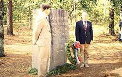
In August 1780, British forces under General Cornwallis defeated the Continental Army led by General Horatio Gates here in one of the worst American losses of the southern campaign. The defeat forced the Continental forces back and gave Britain firmer control over the southern colonies for a period.

The battlefield sits on a mix of private and public land, and visitors can walk along marked trails through the same fields where the two armies once faced each other. Interpretive signs placed around the site help make sense of how the fighting unfolded across the open ground.

The site can be explored on foot or by car, since roads pass through the grounds and connect the main marked positions. Wearing comfortable shoes is a good idea, as some of the best viewpoints require a short walk across uneven ground.

The night before the main battle saw both armies marching toward each other in the dark, colliding unintentionally around 2 AM in an unplanned skirmish. This chance encounter in the dark shaped how both sides positioned themselves for the fight the following morning.

The community of curious travelers

AroundUs brings together thousands of curated places, local tips, and hidden gems, enriched daily by 60,000 contributors worldwide.

Start exploring
Location
Inception
1780
GPS coordinates
34.34639,-80.60750
Latest update
March 3, 2026 13:56
Around this place
Mulberry Plantation
United States of America

Mulberry Plantation

15.6 km
Goodale State Park
United States of America

Goodale State Park

10.3 km
Cool Springs
United States of America

Cool Springs

5.9 km
Bethesda Presbyterian Church
United States of America

Bethesda Presbyterian Church

11.2 km
Boykin Mill Complex
United States of America

Boykin Mill Complex

24.5 km
St. Philip's Episcopal Church
United States of America

St. Philip's Episcopal Church

31.8 km
Mount Carmel A.M.E. Zion Campground
United States of America

Mount Carmel A.M.E. Zion Campground

32 km
City of Camden Historic District
United States of America

City of Camden Historic District

11.1 km
Kendall Mill Historic District
United States of America

Kendall Mill Historic District

9.8 km
Valencia
United States of America

Valencia

34.6 km
Liberty Hill Historic District
United States of America

Liberty Hill Historic District

22.8 km
Zachariah Cantey House
United States of America

Zachariah Cantey House

20.4 km
William Rogers House
United States of America

William Rogers House

35.3 km
Century House
United States of America

Century House

32.6 km
Blink Bonnie
United States of America

Blink Bonnie

19.6 km
Thomas English House
United States of America

Thomas English House

20.4 km
Russell-Heath House
United States of America

Russell-Heath House

24.7 km
Clinton AME Zion Church
United States of America

Clinton AME Zion Church

22.7 km
Dr. William Columbus Cauthen House
United States of America

Dr. William Columbus Cauthen House

23.5 km
Ridgeway Historic District
United States of America

Ridgeway Historic District

32.8 km
Ruff's Chapel
United States of America

Ruff's Chapel

32.5 km
Matson Street Historic District
United States of America

Matson Street Historic District

22.5 km
Monroe Wilson House
United States of America

Monroe Wilson House

33.1 km
Thomas Fraser House
United States of America

Thomas Fraser House

35.1 km
Historic Camden Revolutionary War
United States of America

Historic Camden Revolutionary War

12.6 km
East Richland Street-East Church Street Historic District
United States of America

East Richland Street-East Church Street Historic District

22.9 km
Seaboard Air Line Railway Depot in McBee
United States of America

Seaboard Air Line Railway Depot in McBee

34.9 km
McBee Presbyterian Church
United States of America

McBee Presbyterian Church

34.7 km
Show the full map
Reviews
Share your experience

No review yet

Discussions
Start a discussion...

No discussion yet

« Camden Battlefield - Revolutionary War battlefield in Kershaw County, South Carolina » is provided by Around Us (aroundus.com). Images and texts are derived from Wikimedia project under a Creative Commons license. You are allowed to copy, distribute, and modify copies of this page, under the conditions set by the license, as long as this note is clearly visible.

Discover hidden gems everywhere you go!

From secret cafés to breathtaking viewpoints, skip the crowded tourist spots and find places that match your style. Our app makes it easy with voice search, smart filtering, route optimization, and insider tips from travelers worldwide. Download now for the complete mobile experience.

Around Us App Screenshot

A unique approach to discovering new places

Le Figaro

All the places worth exploring

France Info

A tailor-made excursion in just a few clicks

20 Minutes

Around Us
Travel Guide & Maps
Download

Send to your phone

QR Code
1

Open the camera app on your mobile.

2

Point at the QR code with your camera. A notification will appear.

3

Tap the notification to open the link.