Enable Location

We need your location to show you interesting places around you

Discover nearby places

Find interesting locations and hidden gems around you

Precise directions

Get accurate directions and distances to places

Your location is never shared with other users. It's only used when you tap the location button.

Mulberry Plantation

Log in to your account

Start exploring — it's free

Trusted by 65,541 travelers worldwide

Continue with Google
Continue with Apple
or

We will send you a code to connect

By continuing, you accept our Terms and Conditions and our Privacy Policy

Check your inbox

We've sent a pincode in your inbox. Please enter the code below.

Discussion Reviews 1 Photos
4.6k Popularity

Mulberry Plantation, Historic plantation in Kershaw County, United States

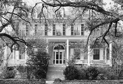
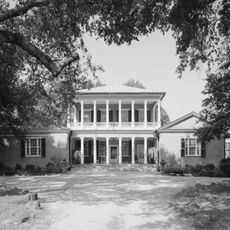
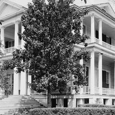
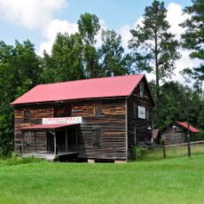
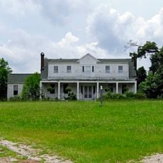
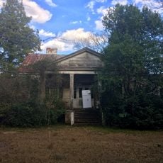
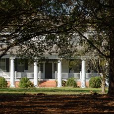
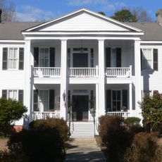
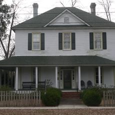
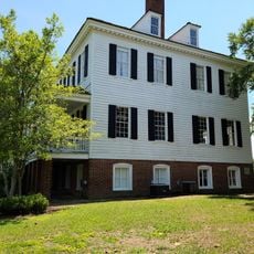
Mulberry Plantation is a historic estate in Kershaw County, South Carolina, centered on a brick house built in the Federal style that stands on high ground near the Wateree River. Three outbuildings from the 1800s remain on the property, including a former servant house and two log barns connected by a lane lined with oak trees.

The land was home to Cofitachequi, a Native American chiefdom that Hernando de Soto passed through in the 16th century. The plantation as a settled estate took shape in later centuries and grew into one of the larger landholdings in the region.

Mary Boykin Chesnut lived here and kept journals that are now among the most read firsthand accounts of the American Civil War. Her writing captures daily life on the plantation from a Southern woman's point of view, and readers still return to her words today.

Comfortable footwear is a good idea because reaching all the buildings means walking the carriage lane and outdoor paths. The ground near the main house is fairly level, though the wider landscape gets more rolling as you move away from the central structures.

Excavations at the McDowell Site on the property uncovered platform mounds and artifacts left by pre-colonial Native American communities. These findings place this land among the most archaeologically significant sites in South Carolina.

The community of curious travelers

AroundUs brings together thousands of curated places, local tips, and hidden gems, enriched daily by 60,000 contributors worldwide.

Start exploring
Location
GPS coordinates
34.20653,-80.59194
Latest update
March 3, 2026 08:12
Around this place
Sesquicentennial State Park
United States of America

Sesquicentennial State Park

31.6 km
Borough House Plantation
United States of America

Borough House Plantation

28.6 km
Camden Battlefield
United States of America

Camden Battlefield

15.6 km
Goodale State Park
United States of America

Goodale State Park

11 km
Cool Springs
United States of America

Cool Springs

9.8 km
Bethesda Presbyterian Church
United States of America

Bethesda Presbyterian Church

4.6 km
Boykin Mill Complex
United States of America

Boykin Mill Complex

8.9 km
St. Philip's Episcopal Church
United States of America

St. Philip's Episcopal Church

19.1 km
Stateburg Historic District
United States of America

Stateburg Historic District

27.3 km
Good Hope Baptist Church
United States of America

Good Hope Baptist Church

31.7 km
City of Camden Historic District
United States of America

City of Camden Historic District

4.7 km
George P. Hoffman House
United States of America

George P. Hoffman House

35 km
Kendall Mill Historic District
United States of America

Kendall Mill Historic District

5.9 km
Lee County Courthouse
United States of America

Lee County Courthouse

31.6 km
Zachariah Cantey House
United States of America

Zachariah Cantey House

5.7 km
William Rogers House
United States of America

William Rogers House

31.1 km
High Hills of Santee Baptist Church
United States of America

High Hills of Santee Baptist Church

25.2 km
Blink Bonnie
United States of America

Blink Bonnie

25.6 km
The Manor
United States of America

The Manor

32.3 km
Thomas English House
United States of America

Thomas English House

6.1 km
Spencer House
United States of America

Spencer House

32.6 km
Ruff's Chapel
United States of America

Ruff's Chapel

35.3 km
Claudius Scott Cottage
United States of America

Claudius Scott Cottage

33.8 km
Thomas Fraser House
United States of America

Thomas Fraser House

30.3 km
James Carnes House
United States of America

James Carnes House

31.3 km
William Apollos James House
United States of America

William Apollos James House

32.6 km
Historic Camden Revolutionary War
United States of America

Historic Camden Revolutionary War

3.2 km
Former Kershaw County Courthouse
United States of America

Former Kershaw County Courthouse

3.9 km
Show the full map
Reviews
Share your experience

No review yet

Discussions
Start a discussion...

No discussion yet

« Mulberry Plantation - Historic plantation in Kershaw County, United States » is provided by Around Us (aroundus.com). Images and texts are derived from Wikimedia project under a Creative Commons license. You are allowed to copy, distribute, and modify copies of this page, under the conditions set by the license, as long as this note is clearly visible.

Discover hidden gems everywhere you go!

From secret cafés to breathtaking viewpoints, skip the crowded tourist spots and find places that match your style. Our app makes it easy with voice search, smart filtering, route optimization, and insider tips from travelers worldwide. Download now for the complete mobile experience.

Around Us App Screenshot

A unique approach to discovering new places

Le Figaro

All the places worth exploring

France Info

A tailor-made excursion in just a few clicks

20 Minutes

Around Us
Travel Guide & Maps
Download

Send to your phone

QR Code
1

Open the camera app on your mobile.

2

Point at the QR code with your camera. A notification will appear.

3

Tap the notification to open the link.