Enable Location

We need your location to show you interesting places around you

Discover nearby places

Find interesting locations and hidden gems around you

Precise directions

Get accurate directions and distances to places

Your location is never shared with other users. It's only used when you tap the location button.

Cayucos State Beach

Log in to your account

Start exploring — it's free

Trusted by 61,999 travelers worldwide

Continue with Google
Continue with Apple
or

We will send you a code to connect

By continuing, you accept our Terms and Conditions and our Privacy Policy

Check your inbox

We've sent a pincode in your inbox. Please enter the code below.

Cayucos State Beach

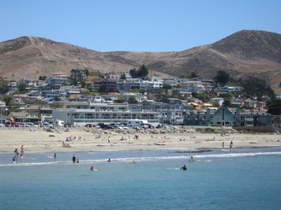
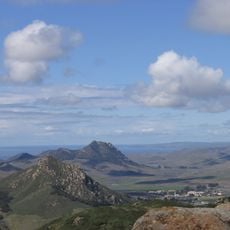
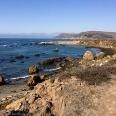
Cayucos State Beach, State beach in Cayucos, US.

Cayucos State Beach is a coastal park with a long sandy shoreline and a wooden pier extending into the Pacific Ocean. The sandy stretch provides open views of the water and space for swimming, walking, and fishing from the pier.

The Chumash people originally lived in this area and established a settlement here long before modern times. The wooden pier was built in 1875 and has been a defining feature of the beach ever since.

The beach serves as a gathering place where locals and visitors spend time together throughout the year for swimming, walking, and socializing. Community events and celebrations regularly draw people to the shoreline, making it central to how residents experience their coast.

The beach has restrooms, showers, picnic tables, and free parking nearby for visitors. The pier is easily accessible and remains a straightforward place to visit at any time of day.

Visitors can fish from the pier without needing a license, making it accessible to anyone wanting to try fishing regardless of experience level. This open-access fishing opportunity sets the pier apart from many other coastal spots.

The community of curious travelers

AroundUs brings together thousands of curated places, local tips, and hidden gems, enriched daily by 60,000 contributors worldwide.

Start exploring
Location
GPS coordinates
35.44860,-120.90600
Latest update
December 10, 2025 20:03
Around this place
California Men's Colony
United States of America

California Men's Colony

23.4 km
Morro Rock
United States of America

Morro Rock

9.5 km
Nitt Witt Ridge
United States of America

Nitt Witt Ridge

21.6 km
Montaña de Oro State Park
United States of America

Montaña de Oro State Park

20.9 km
DSRV-2 Avalon
United States of America

DSRV-2 Avalon

9.9 km
Hearst San Simeon State Park
United States of America

Hearst San Simeon State Park

24.7 km
Bishop Peak
United States of America

Bishop Peak

25 km
Morro Bay State Park
United States of America

Morro Bay State Park

13.4 km
Morro Strand State Beach
United States of America

Morro Strand State Beach

9 km
Los Osos Oaks State Natural Reserve
United States of America

Los Osos Oaks State Natural Reserve

17.9 km
Hollister Peak
United States of America

Hollister Peak

15.9 km
Elfin Forest Natural Area
United States of America

Elfin Forest Natural Area

14.7 km
Whale Rock Reservoir
United States of America

Whale Rock Reservoir

3.2 km
Adelaida Vineyards & Winery
United States of America

Adelaida Vineyards & Winery

23.8 km
Harmony Headlands State Park
United States of America

Harmony Headlands State Park

8.5 km
Carlton Hotel
United States of America

Carlton Hotel

21.9 km
Cerro Cabrillo
United States of America

Cerro Cabrillo

13.6 km
Black Hill
United States of America

Black Hill

12.1 km
Chumash Peak
United States of America

Chumash Peak

24 km
Morro Bay State Park Museum of Natural History
United States of America

Morro Bay State Park Museum of Natural History

12.6 km
San Luis Obispo Botanical Garden
United States of America

San Luis Obispo Botanical Garden

20.6 km
Estero Bluffs State Park
United States of America

Estero Bluffs State Park

2.4 km
Kenneth S. Norris Rancho Marino Reserve
United States of America

Kenneth S. Norris Rancho Marino Reserve

17.8 km
Atascadero Administration Building
United States of America

Atascadero Administration Building

22.1 km
Cerro Romauldo
United States of America

Cerro Romauldo

22.1 km
DAOU Vineyards & Winery
United States of America

DAOU Vineyards & Winery

24.1 km
Niner Wine Estates
United States of America

Niner Wine Estates

20.1 km
Moonstone Beach
United States of America

Moonstone Beach

23.5 km
Show the full map
« Cayucos State Beach - State beach in Cayucos, US » is provided by Around Us (aroundus.com). Images and texts are derived from Wikimedia project under a Creative Commons license. You are allowed to copy, distribute, and modify copies of this page, under the conditions set by the license, as long as this note is clearly visible.

Discover hidden gems everywhere you go!

From secret cafés to breathtaking viewpoints, skip the crowded tourist spots and find places that match your style. Our app makes it easy with voice search, smart filtering, route optimization, and insider tips from travelers worldwide. Download now for the complete mobile experience.

Around Us App Screenshot

A unique approach to discovering new places

Le Figaro

All the places worth exploring

France Info

A tailor-made excursion in just a few clicks

20 Minutes

Around Us
Travel Guide & Maps
Download

Send to your phone

QR Code
1

Open the camera app on your mobile.

2

Point at the QR code with your camera. A notification will appear.

3

Tap the notification to open the link.