Enable Location

We need your location to show you interesting places around you

Discover nearby places

Find interesting locations and hidden gems around you

Precise directions

Get accurate directions and distances to places

Your location is never shared with other users. It's only used when you tap the location button.

Log in to your account

Start exploring — it's free

Trusted by 63,358 travelers worldwide

Continue with Google
Continue with Apple
or

We will send you a code to connect

By continuing, you accept our Terms and Conditions and our Privacy Policy

Check your inbox

We've sent a pincode in your inbox. Please enter the code below.

Druid Heights
Discussion Reviews Photo
36.8k Popularity

Druid Heights, Countercultural settlement in Mill Valley, United States.

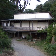
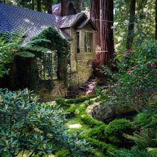
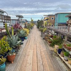
Druid Heights is a five-acre community settlement on Mount Tamalpais's southeast slope, featuring handcrafted buildings including a converted farmhouse with a Polynesian roof and Japanese-style rooms. The structures nestle among cedar and oak trees and comprise sixteen buildings total, with a meditation hut and a library constructed from a repurposed redwood water tank.

Poet Elsa Gidlow purchased the land in 1954 and developed it with carpenter Roger Somers into a thriving community during the 1950s and 1960s. The National Park Service acquired the property in 1977, preserving it for future generations.

The settlement attracted notable artists like musician Dizzy Gillespie, poet Gary Snyder, and philosopher Alan Watts, who gathered here for creative meetings and philosophical discussions. It became a meeting place for thinkers seeking alternative ways of living.

The property is accessible via a three-mile dirt road on Mount Tamalpais's southeast side and lacks city water and sewer connections. Visitors should expect rustic conditions and limited modern amenities.

The site features a library built from a repurposed redwood water tank, showing how residents creatively adapted available materials. These converted structures reflect the practical ingenuity of the community.

The community of curious travelers

AroundUs brings together thousands of curated places, local tips, and hidden gems, enriched daily by 60,000 contributors worldwide.

Start exploring
Inception
1954
Founders
Elsa Gidlow
GPS coordinates
37.88920,-122.56500
Latest update
December 17, 2025 10:41
Around this place
U.S. Army Corps of Engineers Bay Model
United States of America

U.S. Army Corps of Engineers Bay Model

6.8 km
Mount Tamalpais State Park
United States of America

Mount Tamalpais State Park

4.3 km
Green Gulch Farm Zen Center
United States of America

Green Gulch Farm Zen Center

2.6 km
Rodeo Beach
United States of America

Rodeo Beach

7.1 km
Fort Cronkhite
United States of America

Fort Cronkhite

6.9 km
Cushing Memorial Amphitheatre
United States of America

Cushing Memorial Amphitheatre

4.7 km
Benjamin and Hilarita Lyford House
United States of America

Benjamin and Hilarita Lyford House

6.1 km
Muir Beach Overlook
United States of America

Muir Beach Overlook

3.4 km
Lark Theater
United States of America

Lark Theater

5.8 km
Triangle Marsh
United States of America

Triangle Marsh

7 km
Larkspur Downtown Historic District
United States of America

Larkspur Downtown Historic District

5.8 km
Edgewood Botanic Garden
United States of America

Edgewood Botanic Garden

1.6 km
Congregation Kol Shofar
United States of America

Congregation Kol Shofar

5.8 km
Bothin Marsh
United States of America

Bothin Marsh

3.6 km
Silva Island
United States of America

Silva Island

4.4 km
Alley
United States of America

Alley

2.5 km
Tennessee Beach
United States of America

Tennessee Beach

5.4 km
Floating homes viewpoint
United States of America

Floating homes viewpoint

5.9 km
Scenic viewpoint
United States of America

Scenic viewpoint

3.6 km
Scenic viewpoint
United States of America

Scenic viewpoint

5.7 km
Battery Townsley
United States of America

Battery Townsley

6.2 km
Red Rock Beach
United States of America

Red Rock Beach

6 km
Muir Woods Visitor Center
United States of America

Muir Woods Visitor Center

773 m
Slide Ranch North Beach
United States of America

Slide Ranch North Beach

3.6 km
Muir Beach
United States of America

Muir Beach

3.4 km
Muir Woods National Monument Historic District
United States of America

Muir Woods National Monument Historic District

884 m
Muir Woods National Monument Entrance Gate
United States of America

Muir Woods National Monument Entrance Gate

782 m
Pirates Cove
United States of America

Pirates Cove

4.2 km
Show the full map
Reviews
Share your experience

No review yet

Discussions
Start a discussion...

No discussion yet

« Druid Heights - Countercultural settlement in Mill Valley, United States » is provided by Around Us (aroundus.com). Images and texts are derived from Wikimedia project under a Creative Commons license. You are allowed to copy, distribute, and modify copies of this page, under the conditions set by the license, as long as this note is clearly visible.

Discover hidden gems everywhere you go!

From secret cafés to breathtaking viewpoints, skip the crowded tourist spots and find places that match your style. Our app makes it easy with voice search, smart filtering, route optimization, and insider tips from travelers worldwide. Download now for the complete mobile experience.

Around Us App Screenshot

A unique approach to discovering new places

Le Figaro

All the places worth exploring

France Info

A tailor-made excursion in just a few clicks

20 Minutes

Around Us
Travel Guide & Maps
Download

Send to your phone

QR Code
1

Open the camera app on your mobile.

2

Point at the QR code with your camera. A notification will appear.

3

Tap the notification to open the link.