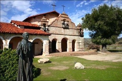
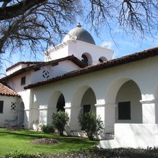
Mission San Antonio de Padua, Franciscan mission in Monterey County, United States.
Mission San Antonio de Padua is a Franciscan mission in Monterey County, United States, with a brick bell tower and extensive adobe structures. The complex follows Spanish colonial design and includes a courtyard, arcades, a cemetery, and several outbuildings surrounding the central church.
Father Junípero Serra founded the complex in 1771 as the third religious settlement in Upper California during Spanish colonial times. The buildings grew over the following decades and underwent several restorations after damage in the 19th century.
The site takes its name from Saint Anthony of Padua and displays artifacts that show how the Salinan people lived and worked. Visitors can see tools, pottery, and textiles made on site that bring daily life in the 18th and 19th centuries closer to understanding.
Access to the complex requires passing through Fort Hunter Liggett Military Reservation checkpoints, roughly 29 miles from King City. Plan to arrive during open hours and allow enough time to walk through the extended buildings and outdoor areas.
The complex introduced the first fired tile roofing system in Upper California, later copied at other sites. It remained at its original location far from coastal settlements, preserving a quieter setting than many other missions.
The community of curious travelers
AroundUs brings together thousands of curated places, local tips, and hidden gems, enriched daily by 60,000 contributors worldwide.