Enable Location

We need your location to show you interesting places around you

Discover nearby places

Find interesting locations and hidden gems around you

Precise directions

Get accurate directions and distances to places

Your location is never shared with other users. It's only used when you tap the location button.

Richmond–San Rafael Bridge

Log in to your account

Start exploring — it's free

Trusted by 63,343 travelers worldwide

Continue with Google
Continue with Apple
or

We will send you a code to connect

By continuing, you accept our Terms and Conditions and our Privacy Policy

Check your inbox

We've sent a pincode in your inbox. Please enter the code below.

Discussion 5.0 1 Reviews 1 Photos
41.5k Popularity

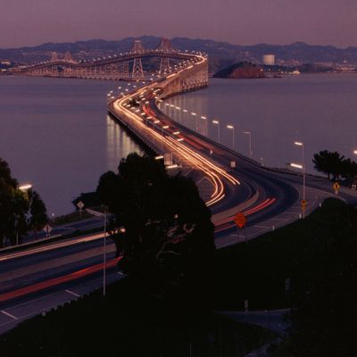
Richmond–San Rafael Bridge, Double-decker bridge between Richmond and San Rafael, United States.

The Richmond–San Rafael Bridge is a double-decker crossing over San Francisco Bay between Richmond and San Rafael in the United States. It consists of steel and includes two roadways on separate levels that run for more than 5.5 miles (8.8 kilometers) in total.

The California transportation authority opened the crossing on September 1, 1956, ending ferry operations between the two cities. The structure was built during a period when the region grew rapidly and needed new routes across the water.

This crossing links the waterfront district of Richmond with the residential areas of Marin County and serves daily commuters traveling between both shores of the bay. The name recalls the two cities that were directly connected for the first time by this structure.

Drivers pay a fee when crossing toward the east, while the upper roadway carries traffic heading west without tolls. On days with heavy fog or high winds, it is advisable to check current conditions before departure.

When wind speeds exceed 70 miles per hour (110 kilometers per hour), authorities close the crossing to all vehicles for safety reasons. Officials constantly monitor weather patterns to prevent hazards for drivers.

The community of curious travelers

AroundUs brings together thousands of curated places, local tips, and hidden gems, enriched daily by 60,000 contributors worldwide.

Start exploring
Location
Location
Inception
September 1, 1956
Official opening
September 1, 1956
Height
99.1 m
Length
8,851.39 m
Width
22 m
Made from material
steel
Part of
Interstate 580, Interstate 180
GPS coordinates
37.93533,-122.44771
Latest update
December 17, 2025 08:09
Around this place
Show the full map
Reviews

Real people, real opinions — but not verified.

Share your experience
bexxxy22
bexxxy22 · Oct 24, 2025
Discussions
Start a discussion...

No discussion yet

« Richmond–San Rafael Bridge - Double-decker bridge between Richmond and San Rafael, United States » is provided by Around Us (aroundus.com). Images and texts are derived from Wikimedia project under a Creative Commons license. You are allowed to copy, distribute, and modify copies of this page, under the conditions set by the license, as long as this note is clearly visible.

Discover hidden gems everywhere you go!

From secret cafés to breathtaking viewpoints, skip the crowded tourist spots and find places that match your style. Our app makes it easy with voice search, smart filtering, route optimization, and insider tips from travelers worldwide. Download now for the complete mobile experience.

Around Us App Screenshot

A unique approach to discovering new places

Le Figaro

All the places worth exploring

France Info

A tailor-made excursion in just a few clicks

20 Minutes

Around Us
Travel Guide & Maps
Download

Send to your phone

QR Code
1

Open the camera app on your mobile.

2

Point at the QR code with your camera. A notification will appear.

3

Tap the notification to open the link.