Enable Location

We need your location to show you interesting places around you

Discover nearby places

Find interesting locations and hidden gems around you

Precise directions

Get accurate directions and distances to places

Your location is never shared with other users. It's only used when you tap the location button.

Winehaven

Log in to your account

Start exploring — it's free

Trusted by 64,629 travelers worldwide

Continue with Google
Continue with Apple
or

We will send you a code to connect

By continuing, you accept our Terms and Conditions and our Privacy Policy

Check your inbox

We've sent a pincode in your inbox. Please enter the code below.

Discussion Reviews 1 Photos
5k Popularity

Winehaven, human settlement in California, United States of America

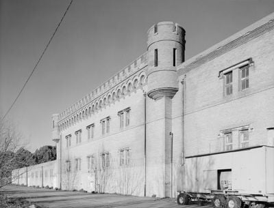
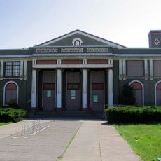
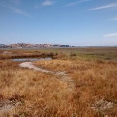
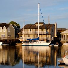
Winehaven is an abandoned harbor settlement on the east shore of San Pablo Bay in Northern California, made up of around 35 early 20th-century buildings. These include a large main building with crenellated walls and corner towers, worker cottages, and old docks reaching into the water.

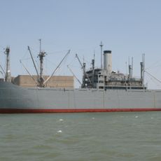
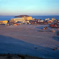
The California Wine Association built the settlement in 1907 after the 1906 earthquake badly damaged San Francisco, and ships carried wine from the docks to Europe and New York. The Prohibition era ended wine production in 1919, and the Navy took over the site in 1941 to use it as a fuel depot.

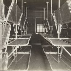
Winehaven was once a self-contained workers' settlement where families lived, ate, and worked without leaving the grounds. The main building, with its tower and castle-like walls, still gives the place a theatrical look that stands out along the flat shoreline.

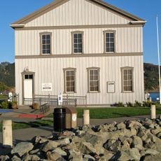
Access to the site is restricted because most buildings are in poor condition and can only be viewed from outside. Visiting during low tide gives a clearer view of the old docks and the waterline.

During World War II, the Navy converted the wine cellars into bomb shelters and control rooms for nuclear materials, turning a place built for wine into a military installation. The main building's castle-like walls were not designed for defense but simply to support the weight of the wine barrels stored inside.

The community of curious travelers

AroundUs brings together thousands of curated places, local tips, and hidden gems, enriched daily by 60,000 contributors worldwide.

Start exploring
Location
GPS coordinates
37.95131,-122.41744
Latest update
March 3, 2026 10:07
Around this place
Angel Island Immigration Station
United States of America

Angel Island Immigration Station

9.1 km
Richmond–San Rafael Bridge
United States of America

Richmond–San Rafael Bridge

3.2 km
Chevron Richmond Refinery
United States of America

Chevron Richmond Refinery

2.2 km
China Camp State Park
United States of America

China Camp State Park

8.2 km
SS Red Oak Victory
United States of America

SS Red Oak Victory

7 km
Terrapin Crossroads
United States of America

Terrapin Crossroads

8.9 km
Ford Motor Company Assembly Plant
United States of America

Ford Motor Company Assembly Plant

6.9 km
East Brother Island Light
United States of America

East Brother Island Light

1.9 km
United States of America

Richmond Inner Harbor

8.7 km
Rosie the Riveter World War II Home Front National Historical Park
United States of America

Rosie the Riveter World War II Home Front National Historical Park

7 km
The Plunge
United States of America

The Plunge

4.2 km
Ring Mountain
United States of America

Ring Mountain

7.6 km
Wapama
United States of America

Wapama

6.7 km
Benjamin and Hilarita Lyford House
United States of America

Benjamin and Hilarita Lyford House

9.4 km
Sikh Center of San Francisco Bay Area El Sobrante
United States of America

Sikh Center of San Francisco Bay Area El Sobrante

8.9 km
Kaiser Richmond Field Hospital
United States of America

Kaiser Richmond Field Hospital

6 km
Point Richmond Historic District
United States of America

Point Richmond Historic District

4 km
Golden State Model Railroad Museum
United States of America

Golden State Model Railroad Museum

5 km
Hotel Mac
United States of America

Hotel Mac

4 km
Southampton Shoal Light
United States of America

Southampton Shoal Light

7.9 km
Marin Shakespeare Company
United States of America

Marin Shakespeare Company

9.4 km
Triangle Marsh
United States of America

Triangle Marsh

7.7 km
Brickyard Cove
United States of America

Brickyard Cove

5.5 km
Belvedere-Tiburon Library
United States of America

Belvedere-Tiburon Library

9.1 km
Congregation Kol Shofar
United States of America

Congregation Kol Shofar

9.1 km
Tiburon Railroad & Ferry Depot Museum
United States of America

Tiburon Railroad & Ferry Depot Museum

9.3 km
Richmond Shipyard Number Three
United States of America

Richmond Shipyard Number Three

6.5 km
Marin Islands National Wildlife Refuge
United States of America

Marin Islands National Wildlife Refuge

5.3 km
Show the full map
Reviews
Share your experience

No review yet

Discussions
Start a discussion...

No discussion yet

« Winehaven - human settlement in California, United States of America » is provided by Around Us (aroundus.com). Images and texts are derived from Wikimedia project under a Creative Commons license. You are allowed to copy, distribute, and modify copies of this page, under the conditions set by the license, as long as this note is clearly visible.

Discover hidden gems everywhere you go!

From secret cafés to breathtaking viewpoints, skip the crowded tourist spots and find places that match your style. Our app makes it easy with voice search, smart filtering, route optimization, and insider tips from travelers worldwide. Download now for the complete mobile experience.

Around Us App Screenshot

A unique approach to discovering new places

Le Figaro

All the places worth exploring

France Info

A tailor-made excursion in just a few clicks

20 Minutes

Around Us
Travel Guide & Maps
Download

Send to your phone

QR Code
1

Open the camera app on your mobile.

2

Point at the QR code with your camera. A notification will appear.

3

Tap the notification to open the link.