·

Enable Location

We need your location to show you interesting places around you

Discover nearby places

Find interesting locations and hidden gems around you

Precise directions

Get accurate directions and distances to places

Your location is never shared with other users. It's only used when you tap the location button.

Dos Amigos Pumping Plant

Log in to your account

Start exploring — it's free

Trusted by 62,650 travelers worldwide

Continue with Google
Continue with Apple
or

We will send you a code to connect

By continuing, you accept our Terms and Conditions and our Privacy Policy

Check your inbox

We've sent a pincode in your inbox. Please enter the code below.

Dos Amigos Pumping Plant

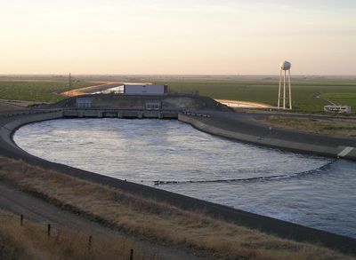
Dos Amigos Pumping Plant, Pumping station in Merced County, California.

Dos Amigos Pumping Plant is a pumping station along the California Aqueduct equipped with six operating units to manage water flow across the state. The facility directs water through a large-scale system connecting the northern and southern regions of California.

This pumping station was constructed between 1963 and 1966 and served as the second major pumping facility for the California Aqueduct system. It was built as part of the state's water infrastructure development.

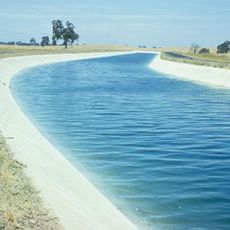
The facility represents California's commitment to water management, supporting agricultural production and urban development across multiple regions of the state.

The station is located about 9 miles south of Los Banos and can be easily located in the area. Keep in mind that this is an active industrial facility, so visitor access may be limited or restricted.

Water leaving this station travels roughly 95 miles before splitting toward the coast near Kettleman City. From that point, gravity carries the water another 66 miles downstream to the next major lifting station.

The community of curious travelers

AroundUs brings together thousands of curated places, local tips, and hidden gems, enriched daily by 60,000 contributors worldwide.

Start exploring
Location
Inception
1966
Operator
California Department of Water Resources
GPS coordinates
36.92248,-120.82815
Latest update
December 13, 2025 17:01
Around this place
San Luis Reservoir
United States of America

San Luis Reservoir

27.7 km
Pacheco Pass
United States of America

Pacheco Pass

38.3 km
Delta–Mendota Canal
United States of America

Delta–Mendota Canal

26.8 km
Pacheco State Park
United States of America

Pacheco State Park

35.6 km
Casa de Fruta
United States of America

Casa de Fruta

49.8 km
San Luis National Wildlife Refuge
United States of America

San Luis National Wildlife Refuge

35.4 km
Merced National Wildlife Refuge
United States of America

Merced National Wildlife Refuge

39.9 km
Randall Fawcett House
United States of America

Randall Fawcett House

6 km
Sierra Azul Open Space Preserve
United States of America

Sierra Azul Open Space Preserve

47.3 km
Hernandez Reservoir
United States of America

Hernandez Reservoir

60 km
Bloss Mansion
United States of America

Bloss Mansion

51.3 km
Church of St. Joseph
United States of America

Church of St. Joseph

15.4 km
Merced County Courthouse
United States of America

Merced County Courthouse

52.6 km
Hollister Carnegie Library
United States of America

Hollister Carnegie Library

51.7 km
Leggett House
United States of America

Leggett House

52.8 km
Castle Air Museum
United States of America

Castle Air Museum

54 km
Pinnacles National Forest
United States of America

Pinnacles National Forest

57.6 km
Thomas H. Leggett House
United States of America

Thomas H. Leggett House

52.7 km
Bank of Los Banos Building
United States of America

Bank of Los Banos Building

15.5 km
Bank of Italy
United States of America

Bank of Italy

52.2 km
Maj. George Beecher Cook House
United States of America

Maj. George Beecher Cook House

52.7 km
Buhach Grammar School
United States of America

Buhach Grammar School

49.9 km
Kaehler-Rector House
United States of America

Kaehler-Rector House

53.1 km
Merced Theatre
United States of America

Merced Theatre

52.2 km
Bear Gulch Reservoir
United States of America

Bear Gulch Reservoir

59.6 km
Juniper Canyon Trail
United States of America

Juniper Canyon Trail

59.2 km
Balconies Trail
United States of America

Balconies Trail

58.3 km
Bear Valley School
United States of America

Bear Valley School

51.8 km
Show the full map
« Dos Amigos Pumping Plant - Pumping station in Merced County, California » is provided by Around Us (aroundus.com). Images and texts are derived from Wikimedia project under a Creative Commons license. You are allowed to copy, distribute, and modify copies of this page, under the conditions set by the license, as long as this note is clearly visible.

Discover hidden gems everywhere you go!

From secret cafés to breathtaking viewpoints, skip the crowded tourist spots and find places that match your style. Our app makes it easy with voice search, smart filtering, route optimization, and insider tips from travelers worldwide. Download now for the complete mobile experience.

Around Us App Screenshot

A unique approach to discovering new places

Le Figaro

All the places worth exploring

France Info

A tailor-made excursion in just a few clicks

20 Minutes

Around Us
Travel Guide & Maps
Download

Send to your phone

QR Code
1

Open the camera app on your mobile.

2

Point at the QR code with your camera. A notification will appear.

3

Tap the notification to open the link.