Chest opened
+${chestReward.xp} XP
Explorer
NOUVEAU ×${chestReward.collectible.quantity}
tapez pour fermer

See the monuments around you in AR Open chests in the app

Around Us is built for your phone — point your camera at the streets and discover the monuments and places around you in augmented reality. Around Us is built for your phone — chests unlock when you walk, explore and capture nearby places.

•

Enable Location

We need your location to show you interesting places around you

Discover nearby places

Find interesting locations and hidden gems around you

Precise directions

Get accurate directions and distances to places

Your location is never shared with other users. It's only used when you tap the location button.

Carquinez Bridge

Log in to your account

Start exploring — it's free

Trusted by 93,239 travelers worldwide

Continue with Google
Continue with Apple
or

We will send you a code to connect

By continuing, you accept our Terms and Conditions and our Privacy Policy

Check your inbox

We've sent a pincode in your inbox. Please enter the code below.

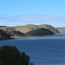
Carquinez Bridge, Toll bridge in Vallejo, United States.

Carquinez Bridge is a road crossing in the San Francisco Bay Area linking Vallejo and Crockett across the Carquinez Strait. The steel structure runs for 1056 meters (about 3500 feet) and combines suspension and cantilever elements in a single span.

The bridge opened on November 11, 2003, replacing an older crossing from the 1920s. It came about as part of a modernization program for the transportation routes around San Francisco Bay.

The suspension span is officially the Alfred Zampa Memorial Bridge, named for an ironworker who began his career on the 1927 Carquinez span in 1925 and also worked on the Golden Gate Bridge; he was one of the few people to survive a fall from it. The 3.6 m pedestrian and bicycle path on the western side opened in May 2004.

Toll is collected only on the northbound 1958 cantilever span, at a station on the north shore; the southbound Alfred Zampa Memorial Bridge is toll-free. A separated pedestrian and bicycle path, 3.6 m wide, runs along the western side of the suspension span and opened in May 2004.

The Carquinez crossing is not one bridge but three built side by side in succession: the 1927 cantilever span was demolished by September 4, 2007, the 1958 cantilever carries northbound traffic, and the 2003 suspension span carries southbound traffic. A 3,000-pound bronze bell that sat atop a pier of the 1927 bridge was taken down and stored for a future museum at the Oakland end of the Bay Bridge.

The community of curious travelers

AroundUs brings together thousands of curated places, local tips, and hidden gems, enriched daily by 93,239 contributors worldwide.

Start exploring
Location
Inception
November 11, 2003
Length
1,056 m
Made from material
steel
GPS coordinates
38.06108,-122.22635
Latest update
October 25, 2026 20:06
Around this place
Glass Beach
United States of America

Glass Beach

3.2 mi
Benicia State Recreation Area
United States of America

Benicia State Recreation Area

2 mi
Eckley
United States of America

Eckley

1.4 mi
Carquinez Strait Regional Shoreline
United States of America

Carquinez Strait Regional Shoreline

2 mi
Port Costa School
United States of America

Port Costa School

2.3 mi
Vallejo Old City Historic District
United States of America

Vallejo Old City Historic District

3.2 mi
United States of America

Bridges & San Francisco Bay Viewpoint

0.3 mi
United States of America

Davis Point

1.9 mi
United States of America

Carquinez Bridge Viewpoint

1.8 mi
United States of America

Scenic viewpoint

1.9 mi
United States of America

Scenic viewpoint

0.4 mi
United States of America

Alfred Zampa Memorial Bridge Viewpoint

0.7 mi
United States of America

Scenic viewpoint, turning circle

3.2 mi
United States of America

Scenic viewpoint

1.8 mi
United States of America

Anchor

2.6 mi
United States of America

Sculpture

0.7 mi
United States of America

Farmers Produce Market

3.2 mi
United States of America

No.519 and 229 Cannons

3.2 mi
United States of America

No.519 and 229 Cannons

3.2 mi
United States of America

Historic US 40 Route

2.4 mi
United States of America

No.519 and 229 Cannons

3.2 mi
United States of America

Historic Route US 40

2.5 mi
United States of America

2003 Alfred Zampa Memorial Suspension Bridge

200 ft
United States of America

1958 Carquinez Bridge

430 ft
United States of America

Lefty Gomez Ballfield Complex

3.1 mi
United States of America

The Spirit Ship

1.8 mi
United States of America

Mare Island Preserve Bunker 2

1.9 mi
United States of America

Mare Island Preserve Bunker 1

2 mi
Show the full map
Reviews
Share your experience

No review yet

Discussions
Start a discussion...

No discussion yet

« Carquinez Bridge - Toll bridge in Vallejo, United States » is provided by Around Us (aroundus.com). Images and texts are derived from Wikimedia project under a Creative Commons license. You are allowed to copy, distribute, and modify copies of this page, under the conditions set by the license, as long as this note is clearly visible.

Discover hidden gems everywhere you go!

From secret cafés to breathtaking viewpoints, skip the crowded tourist spots and find places that match your style. Our app makes it easy with voice search, smart filtering, route optimization, and insider tips from travelers worldwide. Download now for the complete mobile experience.

Around Us App Screenshot
❝

A unique approach to discovering new places❞

— Le Figaro

❝

All the places worth exploring❞

— France Info

❝

A tailor-made excursion in just a few clicks❞

— 20 Minutes

Around Us
Travel Guide & Maps
Download

Send to your phone

QR Code
1

Open the camera app on your mobile.

2

Point at the QR code with your camera. A notification will appear.

3

Tap the notification to open the link.