Enable Location

We need your location to show you interesting places around you

Discover nearby places

Find interesting locations and hidden gems around you

Precise directions

Get accurate directions and distances to places

Your location is never shared with other users. It's only used when you tap the location button.

San Pablo Bay National Wildlife Refuge

Log in to your account

Start exploring — it's free

Trusted by 61,428 travelers worldwide

Continue with Google
Continue with Apple
or

We will send you a code to connect

By continuing, you accept our Terms and Conditions and our Privacy Policy

Check your inbox

We've sent a pincode in your inbox. Please enter the code below.

San Pablo Bay National Wildlife Refuge, National wildlife refuge in Sonoma County, United States.

Description

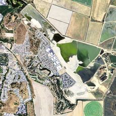
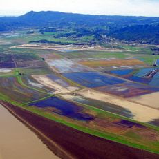
San Pablo Bay National Wildlife Refuge is a protected natural area covering more than 13,000 acres along the northern shore of San Pablo Bay. The landscape consists of mudflats, tidal marshes, and brackish wetlands connected by walking trails and viewing areas.

History

The refuge was established in 1970 to protect the remaining wetlands in this region. This action came after human development had already destroyed or altered 85% of the original tidal marsh system that once dominated the area.

Culture

The refuge serves as a seasonal stopover where thousands of migrating birds rest and feed, shaping the visual landscape with their presence throughout the year. Local communities use trails here to connect with the region's natural patterns and understand coastal ecosystems.

Practical

The Tolay Creek Tubbs Island Trail offers the main way to explore the refuge and is accessible from sunrise to sunset every day. Wear sturdy footwear since the ground can be muddy and soft, especially near water areas.

Did you know?

The refuge hosts the largest wintering population of Canvasback ducks on the entire west coast of North America. These ducks migrate from the north to spend the cold months here, taking advantage of the abundant food sources.

Location
Inception
1970
Operator
United States Fish and Wildlife Service
GPS coordinates
38.14158,-122.40109
Latest update
December 9, 2025 18:43

AroundUs brings together thousands of curated places, local tips, and hidden gems, enriched daily by 60,000 contributors worldwide. Discover all places nearby (Napa County).

Around this place
Sonoma Raceway
United States of America

Sonoma Raceway

5.2 km
Hamilton Air Force Base
United States of America

Hamilton Air Force Base

12 km
Six Flags Discovery Kingdom
United States of America

Six Flags Discovery Kingdom

15 km
The Joker
United States of America

The Joker

14.7 km
Medusa
United States of America

Medusa

14.6 km
Superman: Ultimate Flight
United States of America

Superman: Ultimate Flight

14.9 km
Buena Vista Winery
United States of America

Buena Vista Winery

17.7 km
Olompali State Historic Park
United States of America

Olompali State Historic Park

15.5 km
USS LCS-102
United States of America

USS LCS-102

11.8 km
Roar
United States of America

Roar

14.7 km
Sonoma Plaza
United States of America

Sonoma Plaza

17.5 km
Sonoma TrainTown Railroad
United States of America

Sonoma TrainTown Railroad

15.9 km
The Flash: Vertical Velocity
United States of America

The Flash: Vertical Velocity

14.8 km
Kong
United States of America

Kong

14.6 km
Blue Wing Inn
United States of America

Blue Wing Inn

17.6 km
Mare Island Light
United States of America

Mare Island Light

15.1 km
Harkleroad wind turbine
United States of America

Harkleroad wind turbine

14.8 km
Hamilton Wetland Restoration Project
United States of America

Hamilton Wetland Restoration Project

12 km
Sonoma Valley Museum of Art
United States of America

Sonoma Valley Museum of Art

17.4 km
Black Point Railroad Bridge
United States of America

Black Point Railroad Bridge

9.4 km
First Presbyterian Church
United States of America

First Presbyterian Church

12.1 km
Whiteside marsh
United States of America

Whiteside marsh

13 km
Nash-Patton Adobe
United States of America

Nash-Patton Adobe

17.3 km
Flatiron Building
United States of America

Flatiron Building

14.9 km
Carneros Creek Bridge on Old Sonoma Road
United States of America

Carneros Creek Bridge on Old Sonoma Road

13.9 km
Sebastiani Theatre
United States of America

Sebastiani Theatre

17.5 km
Nativity of Christ Greek Orthodox Church
United States of America

Nativity of Christ Greek Orthodox Church

15.5 km
Vallejo Old City Historic District
United States of America

Vallejo Old City Historic District

13.9 km
Show the full map
« San Pablo Bay National Wildlife Refuge - National wildlife refuge in Sonoma County, United States » is provided by Around Us (aroundus.com). Images and texts are derived from Wikimedia project under a Creative Commons license. You are allowed to copy, distribute, and modify copies of this page, under the conditions set by the license, as long as this note is clearly visible.

Discover hidden gems everywhere you go!

From secret cafés to breathtaking viewpoints, skip the crowded tourist spots and find places that match your style. Our app makes it easy with voice search, smart filtering, route optimization, and insider tips from travelers worldwide. Download now for the complete mobile experience.

Around Us App Screenshot

A unique approach to discovering new places

Le Figaro

All the places worth exploring

France Info

A tailor-made excursion in just a few clicks

20 Minutes

Around Us
Travel Guide & Maps
Download

Send to your phone

QR Code
1

Open the camera app on your mobile.

2

Point at the QR code with your camera. A notification will appear.

3

Tap the notification to open the link.