Enable Location

We need your location to show you interesting places around you

Discover nearby places

Find interesting locations and hidden gems around you

Precise directions

Get accurate directions and distances to places

Your location is never shared with other users. It's only used when you tap the location button.

University High School

Log in to your account

Start exploring — it's free

Trusted by 62,562 travelers worldwide

Continue with Google
Continue with Apple
or

We will send you a code to connect

By continuing, you accept our Terms and Conditions and our Privacy Policy

Check your inbox

We've sent a pincode in your inbox. Please enter the code below.

University High School, public high school serving the northwestern portion of Oakland, California

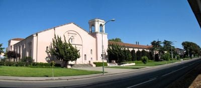
University High School is a public high school in West Los Angeles that opened in 1924 and serves grades 9 through 12. The buildings display Spanish Colonial Revival architecture with brick walls and rounded doorways, and some original features like an octagonal cupola were damaged by earthquakes and later removed.

The school was built in 1923-1924 and was first named Warren G. Harding High School after the recently deceased president. In 1929 it was renamed University High School to reflect its connection to the nearby expanding UCLA campus.

The school sits on land sacred to the Tongva people, whose springs have been a gathering place for thousands of years. Today visitors can see how this Native American heritage remains woven into the campus life through annual celebrations and commemorations.

The school is located in a residential neighborhood with good walkways and is easily accessible to students. The campus is typically closed to visitors during school hours, but the exterior with its historic brick buildings can be viewed from the street.

The school campus is frequently used for film and television productions because its historic brick buildings look like a traditional East Coast school, an unusual sight in Los Angeles. Movie crews have filmed scenes there for major films and popular TV shows, bringing extra revenue to the school.

The community of curious travelers

AroundUs brings together thousands of curated places, local tips, and hidden gems, enriched daily by 60,000 contributors worldwide.

Start exploring
Location
Architectural style
Spanish Colonial Revival architecture
GPS coordinates
37.84250,-122.26806
Latest update
February 9, 2026 08:21
Around this place
People's Park
United States of America

People's Park

2.7 km
Berkeley Art Museum - Pacific Film Archive
United States of America

Berkeley Art Museum - Pacific Film Archive

3.2 km
Haas Pavilion
United States of America

Haas Pavilion

3 km
Emeryville Shellmound
United States of America

Emeryville Shellmound

2.4 km
Berkeley Repertory Theatre
United States of America

Berkeley Repertory Theatre

3.2 km
Sather Gate
United States of America

Sather Gate

3.2 km
University of California Museum of Paleontology
United States of America

University of California Museum of Paleontology

3.2 km
Housing at the University of California, Berkeley
United States of America

Housing at the University of California, Berkeley

3 km
Edwards Stadium
United States of America

Edwards Stadium

3 km
Idora Park
United States of America

Idora Park

431 m
Zellerbach Hall
United States of America

Zellerbach Hall

3 km
Wat Mongkolratanaram
United States of America

Wat Mongkolratanaram

1.6 km
California Hotel
United States of America

California Hotel

2 km
St. John's Presbyterian Church
United States of America

St. John's Presbyterian Church

2.6 km
The Freight and Salvage
United States of America

The Freight and Salvage

3.2 km
La Peña Cultural Center
United States of America

La Peña Cultural Center

1.4 km
J. Mora Moss House
United States of America

J. Mora Moss House

2.2 km
UC Theatre
United States of America

UC Theatre

3.2 km
Berkeley Community Theater
United States of America

Berkeley Community Theater

2.9 km
Shotgun Players
United States of America

Shotgun Players

1.4 km
United States Post Office
United States of America

United States Post Office

2.9 km
First Unitarian Church
United States of America

First Unitarian Church

3 km
Masonic Temple
United States of America

Masonic Temple

2.9 km
Old Berkeley City Hall
United States of America

Old Berkeley City Hall

3 km
St. Mark's Episcopal Church
United States of America

St. Mark's Episcopal Church

2.9 km
South Berkeley Community Church
United States of America

South Berkeley Community Church

943 m
Regal UA Berkeley
United States of America

Regal UA Berkeley

2.8 km
Berkeley Public Library - Central
United States of America

Berkeley Public Library - Central

2.9 km
Show the full map
« University High School - public high school serving the northwestern portion of Oakland, California » is provided by Around Us (aroundus.com). Images and texts are derived from Wikimedia project under a Creative Commons license. You are allowed to copy, distribute, and modify copies of this page, under the conditions set by the license, as long as this note is clearly visible.

Discover hidden gems everywhere you go!

From secret cafés to breathtaking viewpoints, skip the crowded tourist spots and find places that match your style. Our app makes it easy with voice search, smart filtering, route optimization, and insider tips from travelers worldwide. Download now for the complete mobile experience.

Around Us App Screenshot

A unique approach to discovering new places

Le Figaro

All the places worth exploring

France Info

A tailor-made excursion in just a few clicks

20 Minutes

Around Us
Travel Guide & Maps
Download

Send to your phone

QR Code
1

Open the camera app on your mobile.

2

Point at the QR code with your camera. A notification will appear.

3

Tap the notification to open the link.