Enable Location

We need your location to show you interesting places around you

Discover nearby places

Find interesting locations and hidden gems around you

Precise directions

Get accurate directions and distances to places

Your location is never shared with other users. It's only used when you tap the location button.

California Aqueduct

Log in to your account

Start exploring — it's free

Trusted by 61,362 travelers worldwide

Continue with Google
Continue with Apple
or

We will send you a code to connect

By continuing, you accept our Terms and Conditions and our Privacy Policy

Check your inbox

We've sent a pincode in your inbox. Please enter the code below.

California Aqueduct

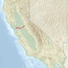
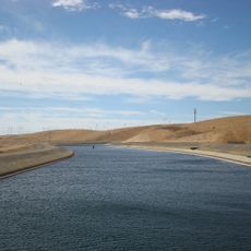
California Aqueduct, Water conveyance system in Kern County, US

Description

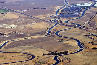
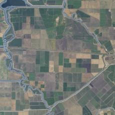
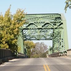
The California Aqueduct is a concrete-lined canal running through Kern County in California, built to move water over long distances with the help of pumping stations. The canal flows through flat farmland and climbs over mountain ranges to deliver water where rainfall is scarce.

History

California launched a large water project in the early 1960s to supply the dry southern part of the state with water from the north. Over the following decades, engineers built a system of canals, pumps and reservoirs to move water across hundreds of miles.

Culture

The California Department of Water Resources maintains this system that supplies water to 27 million residents and irrigates 750,000 acres of agricultural land.

Practical

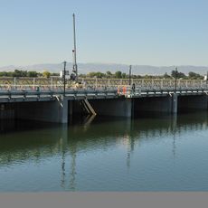
Visitors driving along the canal see long straight stretches of concrete flowing through open farmland, with occasional bridges and control buildings nearby. Access is limited in most areas, but some sections can be viewed from public roads alongside the channel.

Did you know?

One of the pumping plants lifts water nearly 2000 feet (about 600 meters) over a mountain range, a height that requires multiple pumps working in series. This engineering allows the system to reach dry regions on the other side of the mountains.

Location
GPS coordinates
37.82970,-121.55700
Latest update
December 13, 2025 18:10

AroundUs brings together thousands of curated places, local tips, and hidden gems, enriched daily by 60,000 contributors worldwide. Discover all places nearby (Kern County).

Around this place
Centennial Light
United States of America

Centennial Light

23.1 km
Altamont Raceway Park
United States of America

Altamont Raceway Park

10.2 km
Altamont Pass
United States of America

Altamont Pass

12.9 km
USS Lucid
United States of America

USS Lucid

23.3 km
Stagg Memorial Stadium
United States of America

Stagg Memorial Stadium

26.8 km
Franks Tract State Recreation Area
United States of America

Franks Tract State Recreation Area

25.4 km
Haggin Museum
United States of America

Haggin Museum

25.9 km
Stone House of John Marsh
United States of America

Stone House of John Marsh

16.1 km
Mokelumne Aqueduct
United States of America

Mokelumne Aqueduct

14.1 km
Wiley’s Waterpark
United States of America

Wiley’s Waterpark

26.4 km
Contra Costa Canal
United States of America

Contra Costa Canal

22.8 km
Marsh Creek State Park
United States of America

Marsh Creek State Park

17.4 km
Bethany Reservoir
United States of America

Bethany Reservoir

7.6 km
Boomers Livermore
United States of America

Boomers Livermore

26.6 km
Jones Tract
United States of America

Jones Tract

13.5 km
Livermore Carnegie Library and Park
United States of America

Livermore Carnegie Library and Park

25 km
Central Valley Baptist Church
United States of America

Central Valley Baptist Church

26.8 km
Shannon-Williamson Ranch
United States of America

Shannon-Williamson Ranch

23.3 km
Wong K. Gew Mansion
United States of America

Wong K. Gew Mansion

26.4 km
Stockton Waterfront Events Center
United States of America

Stockton Waterfront Events Center

26.9 km
Bank of Tracy
United States of America

Bank of Tracy

15.6 km
Moses Rodgers House
United States of America

Moses Rodgers House

27.1 km
Bank of Italy
United States of America

Bank of Italy

15.7 km
Tracy City Hall and Jail
United States of America

Tracy City Hall and Jail

15.6 km
Children's Museum of Stockton
United States of America

Children's Museum of Stockton

26.6 km
Nippon Hospital
United States of America

Nippon Hospital

27 km
Antioch WaterPark
United States of America

Antioch WaterPark

24.2 km
Manthey Road Bridge
United States of America

Manthey Road Bridge

22.5 km
Show the full map
« California Aqueduct - Water conveyance system in Kern County, US » is provided by Around Us (aroundus.com). Images and texts are derived from Wikimedia project under a Creative Commons license. You are allowed to copy, distribute, and modify copies of this page, under the conditions set by the license, as long as this note is clearly visible.

Discover hidden gems everywhere you go!

From secret cafés to breathtaking viewpoints, skip the crowded tourist spots and find places that match your style. Our app makes it easy with voice search, smart filtering, route optimization, and insider tips from travelers worldwide. Download now for the complete mobile experience.

Around Us App Screenshot

A unique approach to discovering new places

Le Figaro

All the places worth exploring

France Info

A tailor-made excursion in just a few clicks

20 Minutes

Around Us
Travel Guide & Maps
Download

Send to your phone

QR Code
1

Open the camera app on your mobile.

2

Point at the QR code with your camera. A notification will appear.

3

Tap the notification to open the link.