Enable Location

We need your location to show you interesting places around you

Discover nearby places

Find interesting locations and hidden gems around you

Precise directions

Get accurate directions and distances to places

Your location is never shared with other users. It's only used when you tap the location button.

Bethany Reservoir

Log in to your account

Start exploring — it's free

Trusted by 64,612 travelers worldwide

Continue with Google
Continue with Apple
or

We will send you a code to connect

By continuing, you accept our Terms and Conditions and our Privacy Policy

Check your inbox

We've sent a pincode in your inbox. Please enter the code below.

Bethany Reservoir
Discussion Reviews 1 Photos
3.1k Popularity

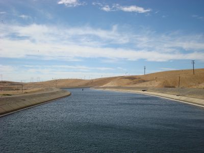
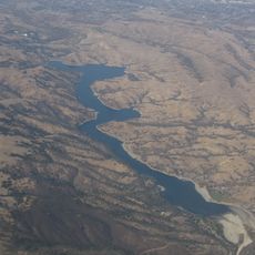
Bethany Reservoir, body of water

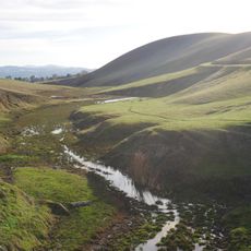
Bethany Reservoir is a water reservoir in northern California, set among rolling hills and open grasslands east of the San Francisco Bay Area. The shoreline is mostly flat and open, with areas designated for fishing and launching non-motorized boats.

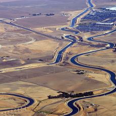
The reservoir was created as part of the California State Water Project, a large system built to move water from the northern part of the state to drier southern regions. Over time, the area around it was opened to the public for outdoor recreation.

The reservoir is a popular spot for fishing, paddling, and sailing, drawing people who want to spend time outdoors without going far from the city. On weekends, you will often see small groups setting up along the shore or launching kayaks and sailboats.

The site is reachable by car and has parking and basic facilities such as restrooms near the water. Summers here can be very hot, so bringing sun protection and enough water to drink is a good idea whenever you plan to stay for a few hours.

Gasoline-powered motorboats are banned on the water, which means the surface stays noticeably quieter than at most lakes in the region. This makes it one of the few places nearby where you can paddle or sail without engine noise in the background.

The community of curious travelers

AroundUs brings together thousands of curated places, local tips, and hidden gems, enriched daily by 60,000 contributors worldwide.

Start exploring
Location
GPS coordinates
37.77083,-121.60083
Latest update
March 3, 2026 13:53
Around this place
Centennial Light
United States of America

Centennial Light

15.8 km
Mount Diablo
United States of America

Mount Diablo

30.2 km
Federal Correctional Institution, Dublin
United States of America

Federal Correctional Institution, Dublin

26.7 km
California Aqueduct
United States of America

California Aqueduct

7.6 km
Altamont Raceway Park
United States of America

Altamont Raceway Park

4.9 km
Altamont Pass
United States of America

Altamont Pass

5.8 km
Black Diamond Mines Regional Preserve
United States of America

Black Diamond Mines Regional Preserve

30.1 km
Blackhawk Museum
United States of America

Blackhawk Museum

28.1 km
USS Lucid
United States of America

USS Lucid

30.5 km
Hacienda del Pozo de Verona
United States of America

Hacienda del Pozo de Verona

29.9 km
Del Valle Regional Park
United States of America

Del Valle Regional Park

21.5 km
Stone House of John Marsh
United States of America

Stone House of John Marsh

17.2 km
Forest Home Farms
United States of America

Forest Home Farms

31 km
Mokelumne Aqueduct
United States of America

Mokelumne Aqueduct

21.7 km
Contra Costa Canal
United States of America

Contra Costa Canal

26.4 km
Marsh Creek State Park
United States of America

Marsh Creek State Park

18 km
Alviso Adobe Community Park
United States of America

Alviso Adobe Community Park

30 km
San Antonio Reservoir
United States of America

San Antonio Reservoir

29.1 km
Jones Tract
United States of America

Jones Tract

21.1 km
Livermore Carnegie Library and Park
United States of America

Livermore Carnegie Library and Park

17.9 km
Shannon-Williamson Ranch
United States of America

Shannon-Williamson Ranch

25.5 km
United States of America

Rose Peak

30.9 km
Doolan Canyon
United States of America

Doolan Canyon

21 km
Bank of Tracy
United States of America

Bank of Tracy

16 km
Bank of Italy
United States of America

Bank of Italy

16 km
Museum on Main
United States of America

Museum on Main

27.1 km
Regal Hacienda Crossings Stadium 20 & IMAX
United States of America

Regal Hacienda Crossings Stadium 20 & IMAX

26.2 km
Manthey Road Bridge
United States of America

Manthey Road Bridge

25.9 km
Show the full map
Reviews
Share your experience

No review yet

Discussions
Start a discussion...

No discussion yet

« Bethany Reservoir - body of water » is provided by Around Us (aroundus.com). Images and texts are derived from Wikimedia project under a Creative Commons license. You are allowed to copy, distribute, and modify copies of this page, under the conditions set by the license, as long as this note is clearly visible.

Discover hidden gems everywhere you go!

From secret cafés to breathtaking viewpoints, skip the crowded tourist spots and find places that match your style. Our app makes it easy with voice search, smart filtering, route optimization, and insider tips from travelers worldwide. Download now for the complete mobile experience.

Around Us App Screenshot

A unique approach to discovering new places

Le Figaro

All the places worth exploring

France Info

A tailor-made excursion in just a few clicks

20 Minutes

Around Us
Travel Guide & Maps
Download

Send to your phone

QR Code
1

Open the camera app on your mobile.

2

Point at the QR code with your camera. A notification will appear.

3

Tap the notification to open the link.