Chest opened
+${chestReward.xp} XP
Explorer
NOUVEAU ×${chestReward.collectible.quantity}
tapez pour fermer
Chest locked

Open chests in the app

Around Us is built for your phone — chests unlock when you walk, explore and capture nearby places.

Enable Location

We need your location to show you interesting places around you

Discover nearby places

Find interesting locations and hidden gems around you

Precise directions

Get accurate directions and distances to places

Your location is never shared with other users. It's only used when you tap the location button.

Siskiyou Summit

Log in to your account

Start exploring — it's free

Trusted by 72,888 travelers worldwide

Continue with Google
Continue with Apple
or

We will send you a code to connect

By continuing, you accept our Terms and Conditions and our Privacy Policy

Check your inbox

We've sent a pincode in your inbox. Please enter the code below.

Siskiyou Summit
Discussion Reviews 1 Photos
17.7k Popularity

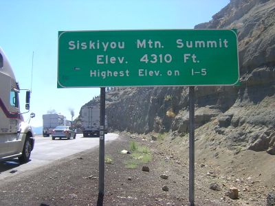
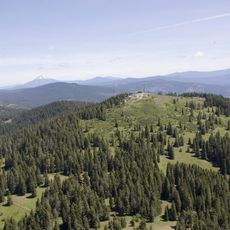
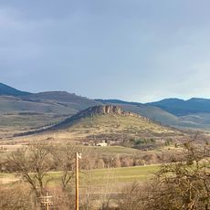
Siskiyou Summit, Mountain pass on Interstate 5 near California border, Oregon

Siskiyou Summit is a mountain pass on Interstate 5 where the highway crosses through a natural gap in the Siskiyou Mountains between Oregon and California. The road rises sharply to reach this high point, which marks the most elevated section of the interstate as it traverses the range.

The pass was first crossed by Europeans in 1827 when Peter Skene Ogden of the Hudson's Bay Company traveled through the area during fur trading expeditions. The route later became an important trading corridor before developing into the modern interstate highway in the 20th century.

The Pacific Crest National Scenic Trail intersects with Interstate 5 at Siskiyou Summit, connecting hikers between Mexico and Canada through this mountain passage.

The pass requires special caution during winter months from November through April, when snowfall and freezing temperatures frequently occur. Travelers should check weather conditions before driving through and be prepared for sudden changes in road conditions.

The road features a steep grade that extends for several miles, requiring truck drivers to use special braking procedures and techniques. This demanding section requires regular brake system maintenance and constant speed control.

The community of curious travelers

AroundUs brings together thousands of curated places, local tips, and hidden gems, enriched daily by 60,000 contributors worldwide.

Start exploring
Location
GPS coordinates
42.06060,-122.60600
Latest update
December 7, 2025 19:24
Around this place
Pacific Crest Trail
United States of America

Pacific Crest Trail

25.9 km
Lithia Park
United States of America

Lithia Park

17.1 km
Copco Lake
United States of America

Copco Lake

26.6 km
Emigrant Lake
United States of America

Emigrant Lake

11.2 km
Ashland Springs Hotel
United States of America

Ashland Springs Hotel

17.4 km
Allen Elizabethan Theatre
United States of America

Allen Elizabethan Theatre

17.6 km
Howard Prairie Lake
United States of America

Howard Prairie Lake

25.7 km
Bear Creek Greenway
United States of America

Bear Creek Greenway

29.4 km
Soda Mountain Wilderness
United States of America

Soda Mountain Wilderness

12.2 km
Tub Springs State Wayside
United States of America

Tub Springs State Wayside

15.2 km
Hyatt Reservoir
United States of America

Hyatt Reservoir

18.8 km
Columbia Hotel
United States of America

Columbia Hotel

17.4 km
Patrick F. McManus House
United States of America

Patrick F. McManus House

29.2 km
Dead Indian Soda Springs
United States of America

Dead Indian Soda Springs

32.9 km
Ashland Masonic Lodge Building
United States of America

Ashland Masonic Lodge Building

17.7 km
First Baptist Church
United States of America

First Baptist Church

17.4 km
I.O.O.F. Building
United States of America

I.O.O.F. Building

17.8 km
Ashland Oregon National Guard Armory
United States of America

Ashland Oregon National Guard Armory

17.7 km
Ashland Hills Hotel and Suites
United States of America

Ashland Hills Hotel and Suites

14.8 km
ScienceWorks Museum
United States of America

ScienceWorks Museum

16.3 km
Japanese Garden
United States of America

Japanese Garden

17.3 km
Trinity Episcopal Church
United States of America

Trinity Episcopal Church

17.4 km
Nils Ahlstrom House
United States of America

Nils Ahlstrom House

16.4 km
Carter Memorial Fountain
United States of America

Carter Memorial Fountain

17.7 km
Pompadour Bluff
United States of America

Pompadour Bluff

16 km
Water Park
United States of America

Water Park

16.6 km
Women's Civic Improvement Clubhouse
United States of America

Women's Civic Improvement Clubhouse

17.6 km
Dutchman Peak Lookout
United States of America

Dutchman Peak Lookout

23.6 km
Show the full map
Reviews
Share your experience

No review yet

Discussions
Start a discussion...

No discussion yet

« Siskiyou Summit - Mountain pass on Interstate 5 near California border, Oregon » is provided by Around Us (aroundus.com). Images and texts are derived from Wikimedia project under a Creative Commons license. You are allowed to copy, distribute, and modify copies of this page, under the conditions set by the license, as long as this note is clearly visible.

Discover hidden gems everywhere you go!

From secret cafés to breathtaking viewpoints, skip the crowded tourist spots and find places that match your style. Our app makes it easy with voice search, smart filtering, route optimization, and insider tips from travelers worldwide. Download now for the complete mobile experience.

Around Us App Screenshot

A unique approach to discovering new places

Le Figaro

All the places worth exploring

France Info

A tailor-made excursion in just a few clicks

20 Minutes

Around Us
Travel Guide & Maps
Download

Send to your phone

QR Code
1

Open the camera app on your mobile.

2

Point at the QR code with your camera. A notification will appear.

3

Tap the notification to open the link.