Chest opened
+${chestReward.xp} XP
Explorer
NOUVEAU ×${chestReward.collectible.quantity}
tapez pour fermer
Chest locked

Open chests in the app

Around Us is built for your phone — chests unlock when you walk, explore and capture nearby places.

Enable Location

We need your location to show you interesting places around you

Discover nearby places

Find interesting locations and hidden gems around you

Precise directions

Get accurate directions and distances to places

Your location is never shared with other users. It's only used when you tap the location button.

Upper and Lower Table Rock

Log in to your account

Start exploring — it's free

Trusted by 72,888 travelers worldwide

Continue with Google
Continue with Apple
or

We will send you a code to connect

By continuing, you accept our Terms and Conditions and our Privacy Policy

Check your inbox

We've sent a pincode in your inbox. Please enter the code below.

Upper and Lower Table Rock
Discussion Reviews 1 Photos
22.4k Popularity

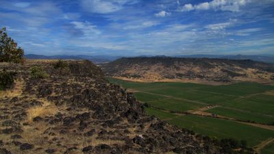
Upper and Lower Table Rock, Volcanic plateau in Jackson County, Oregon, US.

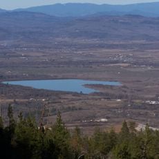
Upper and Lower Table Rock are two flat-topped volcanic plateaus made of andesite rock, rising about 800 feet above the Rogue Valley below. Both formations offer expansive views across the surrounding landscape and valley floor.

These plateaus formed from ancient lava flows that created their distinctive flat tops through andesitic eruptions. In the 1900s, aviation infrastructure was built on the site before it was eventually protected as a natural area.

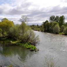
The Takelma people shaped this region for thousands of years, using it as a place to gather acorns and fish from the river below. Visitors walking here can sense the deep connection between the land and those who lived here.

Both plateaus are accessible via marked hiking trails of varying length and difficulty. Visitors should wear proper hiking shoes and bring plenty of water, especially during warmer months.

Seasonal water pools on the plateaus support a rare wildflower found nowhere else on Earth. This small plant shares its habitat with threatened fairy shrimp species that depend on these temporary pools to survive.

The community of curious travelers

AroundUs brings together thousands of curated places, local tips, and hidden gems, enriched daily by 60,000 contributors worldwide.

Start exploring
Location
Inception
1984
Elevation above the sea
637 m
Made from material
andesite
GPS coordinates
42.46500,-122.93500
Latest update
December 20, 2025 16:21
Around this place
Oregon Vortex
United States of America

Oregon Vortex

12.7 km
Valley of the Rogue State Park
United States of America

Valley of the Rogue State Park

18.7 km
Medford Oregon Temple
United States of America

Medford Oregon Temple

10.2 km
Bear Creek Greenway
United States of America

Bear Creek Greenway

23.4 km
Agate Lake
United States of America

Agate Lake

14.8 km
TouVelle State Recreation Site
United States of America

TouVelle State Recreation Site

4.5 km
Jacksonville Historic District
United States of America

Jacksonville Historic District

17.2 km
Holly Theatre
United States of America

Holly Theatre

16.3 km
Medford Carnegie Library
United States of America

Medford Carnegie Library

16.4 km
Jackson County Fairground
United States of America

Jackson County Fairground

9 km
Antelope Creek Bridge
United States of America

Antelope Creek Bridge

11.1 km
Rogue Valley Family Fun Center
United States of America

Rogue Valley Family Fun Center

9.7 km
James A. Redden Federal Courthouse
United States of America

James A. Redden Federal Courthouse

16.2 km
Patrick F. McManus House
United States of America

Patrick F. McManus House

23.6 km
Conro Fiero House
United States of America

Conro Fiero House

9.7 km
Chavner Family House
United States of America

Chavner Family House

9 km
Jackson County Courthouse
United States of America

Jackson County Courthouse

16.5 km
Fort Lane
United States of America

Fort Lane

5.5 km
Frank Chamberlain Clark House
United States of America

Frank Chamberlain Clark House

16.9 km
Wimer Bridge
United States of America

Wimer Bridge

19.4 km
Barnum Hotel
United States of America

Barnum Hotel

16.1 km
Jackson County Courthouse
United States of America

Jackson County Courthouse

16.9 km
Elks Lodge
United States of America

Elks Lodge

16 km
Cornelius C. Beekman House
United States of America

Cornelius C. Beekman House

17.1 km
Craterian Theater
United States of America

Craterian Theater

16.3 km
Roxy Ann Lanes
United States of America

Roxy Ann Lanes

19.3 km
Camp White Station Hospital Administration Building
United States of America

Camp White Station Hospital Administration Building

8.2 km
Doc Griffin spray park
United States of America

Doc Griffin spray park

17.2 km
Show the full map
Reviews
Share your experience

No review yet

Discussions
Start a discussion...

No discussion yet

« Upper and Lower Table Rock - Volcanic plateau in Jackson County, Oregon, US » is provided by Around Us (aroundus.com). Images and texts are derived from Wikimedia project under a Creative Commons license. You are allowed to copy, distribute, and modify copies of this page, under the conditions set by the license, as long as this note is clearly visible.

Discover hidden gems everywhere you go!

From secret cafés to breathtaking viewpoints, skip the crowded tourist spots and find places that match your style. Our app makes it easy with voice search, smart filtering, route optimization, and insider tips from travelers worldwide. Download now for the complete mobile experience.

Around Us App Screenshot

A unique approach to discovering new places

Le Figaro

All the places worth exploring

France Info

A tailor-made excursion in just a few clicks

20 Minutes

Around Us
Travel Guide & Maps
Download

Send to your phone

QR Code
1

Open the camera app on your mobile.

2

Point at the QR code with your camera. A notification will appear.

3

Tap the notification to open the link.