Enable Location

We need your location to show you interesting places around you

Discover nearby places

Find interesting locations and hidden gems around you

Precise directions

Get accurate directions and distances to places

Your location is never shared with other users. It's only used when you tap the location button.

Bandon Marsh National Wildlife Refuge

Log in to your account

Start exploring — it's free

Trusted by 62,474 travelers worldwide

Continue with Google
Continue with Apple
or

We will send you a code to connect

By continuing, you accept our Terms and Conditions and our Privacy Policy

Check your inbox

We've sent a pincode in your inbox. Please enter the code below.

Bandon Marsh National Wildlife Refuge

Bandon Marsh National Wildlife Refuge, National Wildlife Refuge at Coquille River estuary, Oregon, US.

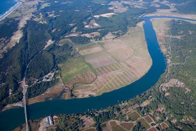
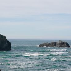
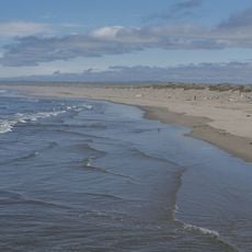
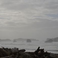
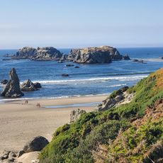
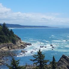
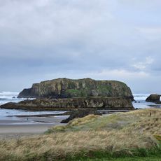
Bandon Marsh National Wildlife Refuge is a nature preserve at the Coquille River estuary in Oregon, consisting of two units that cover roughly 890 acres combined. The landscape contains mudflats, salt marshes, and forested wetlands that stretch toward the Pacific Ocean, displaying different habitats side by side.

The refuge was established in 1983 to protect the largest remaining tidal salt marsh within the Coquille estuary. The site also contains ancient settlements and archaeological remains that extend back before European contact.

The refuge preserves archaeological sites of the Coquille Indian Tribe and provides observation platforms where visitors can experience how migratory birds and local wildlife use the landscape. The trails through the marsh connect different habitats and show how people and nature have shared this space over time.

You can reach the Bandon Marsh Unit by driving north on Riverside Drive from downtown, where marked parking areas and viewing spots await you. The best times to visit are spring and fall when large flocks of shorebirds pass through while stopping to rest.

The mudflats are rich in nutrients and home to clams, crabs, worms, and shrimp that form the food chain for passing birds. During migration seasons, visitors can watch tens of thousands of shorebirds stop briefly to refuel before continuing their journey.

The community of curious travelers

AroundUs brings together thousands of curated places, local tips, and hidden gems, enriched daily by 60,000 contributors worldwide.

Start exploring
Location
GPS coordinates
43.11890,-124.41200
Latest update
December 13, 2025 11:45
Around this place
Bandon Dunes Golf Resort
United States of America

Bandon Dunes Golf Resort

7.9 km
Shore Acres State Park
United States of America

Shore Acres State Park

22.9 km
Sunset Bay State Park
United States of America

Sunset Bay State Park

24.1 km
Face Rock State Scenic Viewpoint
United States of America

Face Rock State Scenic Viewpoint

2.3 km
Bullards Beach State Park
United States of America

Bullards Beach State Park

4.2 km
Coquille River Lighthouse
United States of America

Coquille River Lighthouse

1.1 km
West Coast Game Park Safari
United States of America

West Coast Game Park Safari

12.1 km
Egyptian Theatre
United States of America

Egyptian Theatre

32 km
Bandon State Natural Area
United States of America

Bandon State Natural Area

7.2 km
Coquille Myrtle Grove State Natural Site
United States of America

Coquille Myrtle Grove State Natural Site

30.4 km
Face Rock Viewpoint
United States of America

Face Rock Viewpoint

2.4 km
Bullards Bridge
United States of America

Bullards Bridge

3.4 km
Bullards Beach State Park

Bullards Beach State Park

4.2 km
Cape Arago State Park
United States of America

Cape Arago State Park

20.8 km
Bandon Senior High School
United States of America

Bandon Senior High School

774 m
Port of Bandon
United States of America

Port of Bandon

407 m
Coos County Logging Museum
United States of America

Coos County Logging Museum

22.9 km
Cape Arago Lighthouse
United States of America

Cape Arago Lighthouse

24.9 km
St. James Episcopal Church
United States of America

St. James Episcopal Church

19.5 km
Devils Kitchen
United States of America

Devils Kitchen

4.4 km
Coos Bay National Bank Building
United States of America

Coos Bay National Bank Building

32 km
Marine life center
United States of America

Marine life center

26.1 km
J. S. Coke Building
United States of America

J. S. Coke Building

32.1 km
Washed Ashore Gallery & Volunteer Workshop
United States of America

Washed Ashore Gallery & Volunteer Workshop

387 m
Chandler Hotel and Annex
United States of America

Chandler Hotel and Annex

32 km
Bandon Beach
United States of America

Bandon Beach

3.1 km
Bandon Historical Society Museum
United States of America

Bandon Historical Society Museum

220 m
Something Awesome
United States of America

Something Awesome

10.3 km
Show the full map
« Bandon Marsh National Wildlife Refuge - National Wildlife Refuge at Coquille River estuary, Oregon, US » is provided by Around Us (aroundus.com). Images and texts are derived from Wikimedia project under a Creative Commons license. You are allowed to copy, distribute, and modify copies of this page, under the conditions set by the license, as long as this note is clearly visible.

Discover hidden gems everywhere you go!

From secret cafés to breathtaking viewpoints, skip the crowded tourist spots and find places that match your style. Our app makes it easy with voice search, smart filtering, route optimization, and insider tips from travelers worldwide. Download now for the complete mobile experience.

Around Us App Screenshot

A unique approach to discovering new places

Le Figaro

All the places worth exploring

France Info

A tailor-made excursion in just a few clicks

20 Minutes

Around Us
Travel Guide & Maps
Download

Send to your phone

QR Code
1

Open the camera app on your mobile.

2

Point at the QR code with your camera. A notification will appear.

3

Tap the notification to open the link.