Enable Location

We need your location to show you interesting places around you

Discover nearby places

Find interesting locations and hidden gems around you

Precise directions

Get accurate directions and distances to places

Your location is never shared with other users. It's only used when you tap the location button.

Coquille Myrtle Grove State Natural Site

Log in to your account

Start exploring — it's free

Trusted by 61,532 travelers worldwide

Continue with Google
Continue with Apple
or

We will send you a code to connect

By continuing, you accept our Terms and Conditions and our Privacy Policy

Check your inbox

We've sent a pincode in your inbox. Please enter the code below.

Coquille Myrtle Grove State Natural Site

Coquille Myrtle Grove State Natural Site, State natural site near Myrtle Point, Oregon.

Description

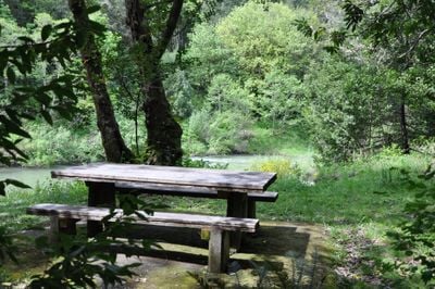
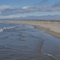
Coquille Myrtle Grove State Natural Site is a protected area featuring a mature stand of Oregon myrtle trees along the South Fork Coquille River in Coos County. The site includes a sandy beach by the water, picnic tables, vault toilets, and a parking area for day visitors.

History

The land was donated to Oregon state in 1950 by Save the Myrtlewoods organization to protect remaining stands of Oregon myrtle trees from logging. This gift created the foundation for the protected site that exists along this river section today.

Culture

Oregon myrtle wood has been crafted by local artisans for generations into decorative and practical objects that people still treasure today. The presence of these trees here reflects how the region's communities have valued this specific timber for their own creations.

Practical

Bring your own drinking water since none is available at the site. The facilities are basic but adequate for a day visit with picnic areas and restroom access.

Did you know?

During summer months a rope swing hangs over a natural swimming hole in the river, allowing visitors to float in the gentle current. This simple addition has become a favorite spot for cooling off on hot days and adds a playful element to the visit.

Location
Inception
1950
GPS coordinates
42.96222,-124.10667
Latest update
December 14, 2025 11:25

AroundUs brings together thousands of curated places, local tips, and hidden gems, enriched daily by 60,000 contributors worldwide. Discover all places nearby (Coos County).

Around this place
Bandon Dunes Golf Resort
United States of America

Bandon Dunes Golf Resort

34.1 km
Face Rock State Scenic Viewpoint
United States of America

Face Rock State Scenic Viewpoint

31.2 km
Bullards Beach State Park
United States of America

Bullards Beach State Park

32.8 km
Coquille River Lighthouse
United States of America

Coquille River Lighthouse

31.5 km
West Coast Game Park Safari
United States of America

West Coast Game Park Safari

25.7 km
Cape Blanco Light
United States of America

Cape Blanco Light

39.6 km
Rogue River Ranch
United States of America

Rogue River Ranch

32.7 km
Zane Grey Cabin
United States of America

Zane Grey Cabin

38 km
Grassy Knob Wilderness
United States of America

Grassy Knob Wilderness

30.5 km
Bandon Marsh National Wildlife Refuge
United States of America

Bandon Marsh National Wildlife Refuge

30.4 km
Bandon State Natural Area
United States of America

Bandon State Natural Area

28.7 km
Face Rock Viewpoint
United States of America

Face Rock Viewpoint

31.1 km
Bullards Bridge
United States of America

Bullards Bridge

31.3 km
Patrick Hughes House
United States of America

Patrick Hughes House

37.5 km
Bullards Beach State Park

Bullards Beach State Park

32.5 km
Bandon Senior High School
United States of America

Bandon Senior High School

30.7 km
Sandy Creek Bridge
United States of America

Sandy Creek Bridge

18.2 km
Cape Blanco State Park
United States of America

Cape Blanco State Park

38.2 km
Port of Bandon
United States of America

Port of Bandon

30.8 km
Coos County Logging Museum
United States of America

Coos County Logging Museum

11.7 km
St. James Episcopal Church
United States of America

St. James Episcopal Church

24.8 km
Devils Kitchen
United States of America

Devils Kitchen

29.8 km
Washed Ashore Gallery & Volunteer Workshop
United States of America

Washed Ashore Gallery & Volunteer Workshop

30.7 km
Bandon Beach
United States of America

Bandon Beach

30.6 km
Bandon Historical Society Museum
United States of America

Bandon Historical Society Museum

30.2 km
Something Awesome
United States of America

Something Awesome

26.1 km
First National Bank of Bandon
United States of America

First National Bank of Bandon

30.5 km
Sandy Creek Covered Bridge, Oregon
United States of America

Sandy Creek Covered Bridge, Oregon

18.2 km
Show the full map
« Coquille Myrtle Grove State Natural Site - State natural site near Myrtle Point, Oregon » is provided by Around Us (aroundus.com). Images and texts are derived from Wikimedia project under a Creative Commons license. You are allowed to copy, distribute, and modify copies of this page, under the conditions set by the license, as long as this note is clearly visible.

Discover hidden gems everywhere you go!

From secret cafés to breathtaking viewpoints, skip the crowded tourist spots and find places that match your style. Our app makes it easy with voice search, smart filtering, route optimization, and insider tips from travelers worldwide. Download now for the complete mobile experience.

Around Us App Screenshot

A unique approach to discovering new places

Le Figaro

All the places worth exploring

France Info

A tailor-made excursion in just a few clicks

20 Minutes

Around Us
Travel Guide & Maps
Download

Send to your phone

QR Code
1

Open the camera app on your mobile.

2

Point at the QR code with your camera. A notification will appear.

3

Tap the notification to open the link.