Sandy Creek Bridge

Log in to your account

AroundUs is a community-driven map of interesting places, built by curious explorers like you. It grows with every review, story, and photo you share.
Connect to save your favorite spots, contribute locations, and create personalized routes.
Continue with Google
Continue with Apple
Continue with X
Continue with Facebook
Continue with email
By continuing, you accept our Terms and Conditions and our Privacy Policy
Create an account
Add to collection
Map
Suggest a change
Share

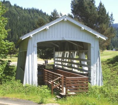
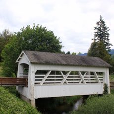
Sandy Creek Bridge, Covered bridge in Coos County, US.

Sandy Creek Bridge is a covered bridge in Coos County that spans Sandy Creek near the community of Remote, featuring large side openings and a dual Howe truss structure. The structure now sits in a county park at its original location and is accessible to visitors on foot.

The structure was built in 1921 and served traffic on Oregon Route 42 until 1949, when a newer bridge replaced it for vehicle use. After it was taken out of service, the bridge was preserved and later restored by the Myrtle Point Lions Club.

The bridge shows how wooden structures in this region were protected from the Pacific Northwest's wet climate through covered designs. Visitors today can see how these protective measures shaped the overall form.

The structure sits within a park setting and is easy to reach on foot, with clear pathways and open space around it. The best time to visit is during dry weather, when the wooden elements are easy to see and photograph.

This is the last remaining covered bridge in the county and was added to the National Register of Historic Places in 1979. This recognition made it a protected historic landmark of regional importance.

Location: Coos County

GPS coordinates: 43.00637,-123.89177

Latest update: December 14, 2025 18:05

Photos
Around this place
Bandon Dunes Golf Resort
United States of America

Bandon Dunes Golf Resort

45.3 km
Wildlife Safari
United States of America

Wildlife Safari

40.8 km
Face Rock State Scenic Viewpoint
United States of America

Face Rock State Scenic Viewpoint

45.6 km
Bullards Beach State Park
United States of America

Bullards Beach State Park

45.3 km
Coquille River Lighthouse
United States of America

Coquille River Lighthouse

45.2 km
West Coast Game Park Safari
United States of America

West Coast Game Park Safari

42.6 km
Rogue River Ranch
United States of America

Rogue River Ranch

32 km
Zane Grey Cabin
United States of America

Zane Grey Cabin

34.6 km
Bandon Marsh National Wildlife Refuge
United States of America

Bandon Marsh National Wildlife Refuge

44.1 km
Bandon State Natural Area
United States of America

Bandon State Natural Area

44.5 km
Coquille Myrtle Grove State Natural Site
United States of America

Coquille Myrtle Grove State Natural Site

18.2 km
Face Rock Viewpoint
United States of America

Face Rock Viewpoint

45.5 km
Bullards Bridge
United States of America

Bullards Bridge

43.9 km
Bullards Beach State Park

Bullards Beach State Park

45 km
Bandon Senior High School
United States of America

Bandon Senior High School

44.7 km
Whisky Creek Cabin
United States of America

Whisky Creek Cabin

43.9 km
Port of Bandon
United States of America

Port of Bandon

44.5 km
Coos County Logging Museum
United States of America

Coos County Logging Museum

21.2 km
James Wimer Octagonal Barn
United States of America

James Wimer Octagonal Barn

36.8 km
St. James Episcopal Church
United States of America

St. James Episcopal Church

30.5 km
Devils Kitchen
United States of America

Devils Kitchen

44.9 km
Washed Ashore Gallery & Volunteer Workshop
United States of America

Washed Ashore Gallery & Volunteer Workshop

44.5 km
Bandon Beach
United States of America

Bandon Beach

45.3 km
Bandon Historical Society Museum
United States of America

Bandon Historical Society Museum

43.9 km
Something Awesome
United States of America

Something Awesome

42.6 km
Chandler Bridge
United States of America

Chandler Bridge

45.3 km
First National Bank of Bandon
United States of America

First National Bank of Bandon

44.3 km
Sandy Creek Covered Bridge, Oregon
United States of America

Sandy Creek Covered Bridge, Oregon

2 m
Show the full map
Reviews

Visited this place? Tap the stars to rate it and share your experience / photos with the community! Try now! You can cancel it anytime.

« Sandy Creek Bridge - Covered bridge in Coos County, US » is provided by Around Us (aroundus.com). Images and texts are derived from Wikimedia project under a Creative Commons license. You are allowed to copy, distribute, and modify copies of this page, under the conditions set by the license, as long as this note is clearly visible.

Discover hidden gems everywhere you go!

From secret cafés to breathtaking viewpoints, skip the crowded tourist spots and find places that match your style. Our app makes it easy with voice search, smart filtering, route optimization, and insider tips from travelers worldwide. Download now for the complete mobile experience.

Around Us App Screenshot

A unique approach to discovering new places

Le Figaro

All the places worth exploring

France Info

A tailor-made excursion in just a few clicks

20 Minutes