Enable Location

We need your location to show you interesting places around you

Discover nearby places

Find interesting locations and hidden gems around you

Precise directions

Get accurate directions and distances to places

Your location is never shared with other users. It's only used when you tap the location button.

Bullards Bridge

Log in to your account

Start exploring — it's free

Trusted by 62,460 travelers worldwide

Continue with Google
Continue with Apple
or

We will send you a code to connect

By continuing, you accept our Terms and Conditions and our Privacy Policy

Check your inbox

We've sent a pincode in your inbox. Please enter the code below.

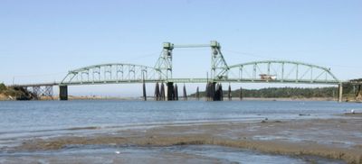
Bullards Bridge, Vertical-lift bridge in Coos County, Oregon, US.

Bullards Bridge is a vertical-lift bridge in Coos County, Oregon, that crosses the Coquille River near the Pacific Coast. It features two camelback truss spans and measures about 700 feet across the river.

The Oregon Highway Commission began construction in 1952 to replace the former Bullards Ferry, completing the work in September 1954. This new crossing eliminated the need for the old ferry service and gave the area its first permanent road link.

This bridge holds importance for the local fishing community, linking residents to maritime work along the Coquille River. It shapes daily life for people who depend on it to reach their jobs and the river's docks.

The bridge is easy to reach as it sits on the main coastal route and is open to regular traffic. Visitors with tall vehicles should be aware of the clearance height when passing underneath.

This is one of only two vertical-lift bridges along the Oregon Coast Highway, yet it operates mainly for annual testing procedures rather than regular traffic. The lifting mechanism uses a design rarely seen elsewhere in the region.

The community of curious travelers

AroundUs brings together thousands of curated places, local tips, and hidden gems, enriched daily by 60,000 contributors worldwide.

Start exploring
Location
Inception
1952
Official opening
1954
GPS coordinates
43.14710,-124.39600
Latest update
December 14, 2025 13:00
Around this place
Bandon Dunes Golf Resort
United States of America

Bandon Dunes Golf Resort

4.6 km
Shore Acres State Park
United States of America

Shore Acres State Park

19.7 km
Sunset Bay State Park
United States of America

Sunset Bay State Park

20.8 km
Face Rock State Scenic Viewpoint
United States of America

Face Rock State Scenic Viewpoint

5.5 km
Bullards Beach State Park
United States of America

Bullards Beach State Park

1.5 km
Coquille River Lighthouse
United States of America

Coquille River Lighthouse

3.5 km
West Coast Game Park Safari
United States of America

West Coast Game Park Safari

15.3 km
Egyptian Theatre
United States of America

Egyptian Theatre

28.6 km
Bandon Marsh National Wildlife Refuge
United States of America

Bandon Marsh National Wildlife Refuge

3.4 km
Bandon State Natural Area
United States of America

Bandon State Natural Area

10.6 km
Face Rock Viewpoint
United States of America

Face Rock Viewpoint

5.6 km
Bullards Beach State Park

Bullards Beach State Park

1.3 km
Cape Arago State Park
United States of America

Cape Arago State Park

17.6 km
Bandon Senior High School
United States of America

Bandon Senior High School

4 km
Port of Bandon
United States of America

Port of Bandon

3.3 km
Coos County Logging Museum
United States of America

Coos County Logging Museum

22.8 km
Cape Arago Lighthouse
United States of America

Cape Arago Lighthouse

21.7 km
St. James Episcopal Church
United States of America

St. James Episcopal Church

17.4 km
Devils Kitchen
United States of America

Devils Kitchen

7.8 km
Coos Bay National Bank Building
United States of America

Coos Bay National Bank Building

28.6 km
Marine life center
United States of America

Marine life center

22.7 km
Washed Ashore Gallery & Volunteer Workshop
United States of America

Washed Ashore Gallery & Volunteer Workshop

3.4 km
Chandler Hotel and Annex
United States of America

Chandler Hotel and Annex

28.7 km
Bandon Beach
United States of America

Bandon Beach

6.4 km
Bandon Historical Society Museum
United States of America

Bandon Historical Society Museum

3.3 km
Something Awesome
United States of America

Something Awesome

13.5 km
First National Bank of Bandon
United States of America

First National Bank of Bandon

3.5 km
Cape Arago Highway
United States of America

Cape Arago Highway

26.4 km
Show the full map
« Bullards Bridge - Vertical-lift bridge in Coos County, Oregon, US » is provided by Around Us (aroundus.com). Images and texts are derived from Wikimedia project under a Creative Commons license. You are allowed to copy, distribute, and modify copies of this page, under the conditions set by the license, as long as this note is clearly visible.

Discover hidden gems everywhere you go!

From secret cafés to breathtaking viewpoints, skip the crowded tourist spots and find places that match your style. Our app makes it easy with voice search, smart filtering, route optimization, and insider tips from travelers worldwide. Download now for the complete mobile experience.

Around Us App Screenshot

A unique approach to discovering new places

Le Figaro

All the places worth exploring

France Info

A tailor-made excursion in just a few clicks

20 Minutes

Around Us
Travel Guide & Maps
Download

Send to your phone

QR Code
1

Open the camera app on your mobile.

2

Point at the QR code with your camera. A notification will appear.

3

Tap the notification to open the link.