Chest opened
+${chestReward.xp} XP
Explorer
NOUVEAU ×${chestReward.collectible.quantity}
tapez pour fermer
Chest locked

Open chests in the app

Around Us is built for your phone — chests unlock when you walk, explore and capture nearby places.

Enable Location

We need your location to show you interesting places around you

Discover nearby places

Find interesting locations and hidden gems around you

Precise directions

Get accurate directions and distances to places

Your location is never shared with other users. It's only used when you tap the location button.

Port of Coos Bay

Log in to your account

Start exploring — it's free

Trusted by 72,876 travelers worldwide

Continue with Google
Continue with Apple
or

We will send you a code to connect

By continuing, you accept our Terms and Conditions and our Privacy Policy

Check your inbox

We've sent a pincode in your inbox. Please enter the code below.

Port of Coos Bay
Discussion Reviews 1 Photos
3.8k Popularity

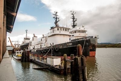
Port of Coos Bay, Maritime freight terminal in Coos Bay, Oregon, United States.

The Port of Coos Bay is a deep-water freight terminal on the Oregon coast that handles large cargo vessels. The facility includes specialized loading equipment and rail connections for moving goods inland and along the coast.

The facility grew into one of the world's largest lumber shipping ports during the mid-1900s. This importance was built on proximity to vast forests and the ability to export massive quantities of wood products.

The port shapes daily life in town through its handling of lumber, which moves through the docks regularly. This link to regional forestry remains a visible part of the community's identity today.

The port is accessible by water and served by modern loading equipment that handles various cargo types. Visitors should know this is an active working facility where ships and trucks move constantly.

The port connects the Pacific coast with inland areas through a rail line that provides direct access to production facilities further north. This rail connection makes it a key transfer point between ship and rail transport.

The community of curious travelers

AroundUs brings together thousands of curated places, local tips, and hidden gems, enriched daily by 60,000 contributors worldwide.

Start exploring
GPS coordinates
43.42917,-124.22917
Latest update
December 11, 2025 18:08
Around this place
Oregon Dunes National Recreation Area
United States of America

Oregon Dunes National Recreation Area

33.1 km
Bandon Dunes Golf Resort
United States of America

Bandon Dunes Golf Resort

29.8 km
Shore Acres State Park
United States of America

Shore Acres State Park

17.1 km
Conde McCullough Memorial Bridge
United States of America

Conde McCullough Memorial Bridge

617 m
Sunset Bay State Park
United States of America

Sunset Bay State Park

15.7 km
Umpqua River Light
United States of America

Umpqua River Light

26.1 km
Elliott State Forest
United States of America

Elliott State Forest

24.3 km
William M. Tugman State Park
United States of America

William M. Tugman State Park

19.6 km
Coast Guard Air Station North Bend
United States of America

Coast Guard Air Station North Bend

2.4 km
Egyptian Theatre
United States of America

Egyptian Theatre

7.1 km
Golden and Silver Falls State Natural Area
United States of America

Golden and Silver Falls State Natural Area

24.8 km
Umpqua River Bridge
United States of America

Umpqua River Bridge

32.9 km
Cape Arago State Park
United States of America

Cape Arago State Park

19.2 km
Cape Arago Lighthouse
United States of America

Cape Arago Lighthouse

15.4 km
Haynes Inlet Bridge
United States of America

Haynes Inlet Bridge

1.4 km
Lighthouse Beach
United States of America

Lighthouse Beach

15 km
St. James Episcopal Church
United States of America

St. James Episcopal Church

28.3 km
Coos Bay National Bank Building
United States of America

Coos Bay National Bank Building

6.9 km
Coos History Museum
United States of America

Coos History Museum

6.1 km
Marine life center
United States of America

Marine life center

12.3 km
J. S. Coke Building
United States of America

J. S. Coke Building

6.9 km
Chandler Hotel and Annex
United States of America

Chandler Hotel and Annex

6.9 km
Merchants Beach
United States of America

Merchants Beach

25.1 km
Bastendorff Beach
United States of America

Bastendorff Beach

13.4 km
Port Theater
United States of America

Port Theater

2.5 km
Whisky Run Beach
United States of America

Whisky Run Beach

27.7 km
Liberty Theatre
United States of America

Liberty Theatre

2.7 km
Chandler Bridge
United States of America

Chandler Bridge

9.3 km
Show the full map
Reviews
Share your experience

No review yet

Discussions
Start a discussion...

No discussion yet

« Port of Coos Bay - Maritime freight terminal in Coos Bay, Oregon, United States » is provided by Around Us (aroundus.com). Images and texts are derived from Wikimedia project under a Creative Commons license. You are allowed to copy, distribute, and modify copies of this page, under the conditions set by the license, as long as this note is clearly visible.

Discover hidden gems everywhere you go!

From secret cafés to breathtaking viewpoints, skip the crowded tourist spots and find places that match your style. Our app makes it easy with voice search, smart filtering, route optimization, and insider tips from travelers worldwide. Download now for the complete mobile experience.

Around Us App Screenshot

A unique approach to discovering new places

Le Figaro

All the places worth exploring

France Info

A tailor-made excursion in just a few clicks

20 Minutes

Around Us
Travel Guide & Maps
Download

Send to your phone

QR Code
1

Open the camera app on your mobile.

2

Point at the QR code with your camera. A notification will appear.

3

Tap the notification to open the link.