Enable Location

We need your location to show you interesting places around you

Discover nearby places

Find interesting locations and hidden gems around you

Precise directions

Get accurate directions and distances to places

Your location is never shared with other users. It's only used when you tap the location button.

Umpqua River Light

Log in to your account

Start exploring — it's free

Trusted by 65,612 travelers worldwide

Continue with Google
Continue with Apple
or

We will send you a code to connect

By continuing, you accept our Terms and Conditions and our Privacy Policy

Check your inbox

We've sent a pincode in your inbox. Please enter the code below.

Discussion Reviews 1 Photos
4.8k Popularity

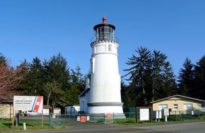
Umpqua River Light, Lighthouse in Winchester Bay, United States.

Umpqua River Light is a red brick lighthouse standing on a coastal bluff above Winchester Bay in Douglas County, Oregon, rising about 65 feet (20 meters) tall. Inside, a large Fresnel lens rotates and casts red and white beams across the water.

The first lighthouse at this location was built in 1857 but collapsed into the river within a few years after the ground beneath it was eroded away. The current tower was completed in 1894 and placed at a safer spot on the bluff, where it has operated ever since.

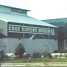
The museum in a former Coast Guard building displays ships' equipment, navigation tools, and old maps that show how fishermen and sailors once used these waters. The collection tells the story of people who worked daily with the sea.

The tower is generally open to visitors between May and October, and those who want to go up should be comfortable climbing a very narrow spiral staircase. The space at the top is tight, so the climb may not suit everyone.

The former Coast Guard building next to the tower now houses a small museum with ships' equipment, navigation tools, and old maps from the era when these waters were heavily used by fishermen and sailors. Walking through it gives a concrete sense of how daily work at sea was organized before modern technology.

The community of curious travelers

AroundUs brings together thousands of curated places, local tips, and hidden gems, enriched daily by 60,000 contributors worldwide.

Start exploring
Location
Height
20 m
Made from material
brick
GPS coordinates
43.66230,-124.19800
Latest update
March 3, 2026 08:13
Around this place
Oregon Dunes National Recreation Area
United States of America

Oregon Dunes National Recreation Area

7.1 km
Jessie M. Honeyman Memorial State Park
United States of America

Jessie M. Honeyman Memorial State Park

30.6 km
Conde McCullough Memorial Bridge
United States of America

Conde McCullough Memorial Bridge

26.3 km
Elliott State Forest
United States of America

Elliott State Forest

16.9 km
William M. Tugman State Park
United States of America

William M. Tugman State Park

7 km
Coast Guard Air Station North Bend
United States of America

Coast Guard Air Station North Bend

28.4 km
Egyptian Theatre
United States of America

Egyptian Theatre

32.9 km
Devil's Staircase Wilderness
United States of America

Devil's Staircase Wilderness

23.3 km
Golden and Silver Falls State Natural Area
United States of America

Golden and Silver Falls State Natural Area

29.2 km
Umpqua State Scenic Corridor
United States of America

Umpqua State Scenic Corridor

23.5 km
Umpqua River Bridge
United States of America

Umpqua River Bridge

9.5 km
Dean Creek Wildlife Area
United States of America

Dean Creek Wildlife Area

13.4 km
Haynes Inlet Bridge
United States of America

Haynes Inlet Bridge

24.8 km
Coos Bay National Bank Building
United States of America

Coos Bay National Bank Building

32.8 km
Coos History Museum
United States of America

Coos History Museum

31.9 km
J. S. Coke Building
United States of America

J. S. Coke Building

32.8 km
Chandler Hotel and Annex
United States of America

Chandler Hotel and Annex

32.8 km
Eye of the Needle
United States of America

Eye of the Needle

30.7 km
Port Theater
United States of America

Port Theater

28.5 km
Liberty Theatre
United States of America

Liberty Theatre

28.7 km
Chandler Bridge
United States of America

Chandler Bridge

33.2 km
Jessie M. Honeyman Memorial State Park Historic District
United States of America

Jessie M. Honeyman Memorial State Park Historic District

30.7 km
Jessie M. Honeyman Memorial State Park Hexagonal Kitchen Shelter
United States of America

Jessie M. Honeyman Memorial State Park Hexagonal Kitchen Shelter

30.8 km
Gardiner Historic District
United States of America

Gardiner Historic District

10.4 km
Gardiner Cemetery
United States of America

Gardiner Cemetery

10.8 km
Scottsburg Bridge
United States of America

Scottsburg Bridge

30 km
Scottsburg Bridge
United States of America

Scottsburg Bridge

30 km
Cape Arago Highway
United States of America

Cape Arago Highway

33.2 km
Show the full map
Reviews
Share your experience

No review yet

Discussions
Start a discussion...

No discussion yet

« Umpqua River Light - Lighthouse in Winchester Bay, United States » is provided by Around Us (aroundus.com). Images and texts are derived from Wikimedia project under a Creative Commons license. You are allowed to copy, distribute, and modify copies of this page, under the conditions set by the license, as long as this note is clearly visible.

Discover hidden gems everywhere you go!

From secret cafés to breathtaking viewpoints, skip the crowded tourist spots and find places that match your style. Our app makes it easy with voice search, smart filtering, route optimization, and insider tips from travelers worldwide. Download now for the complete mobile experience.

Around Us App Screenshot

A unique approach to discovering new places

Le Figaro

All the places worth exploring

France Info

A tailor-made excursion in just a few clicks

20 Minutes

Around Us
Travel Guide & Maps
Download

Send to your phone

QR Code
1

Open the camera app on your mobile.

2

Point at the QR code with your camera. A notification will appear.

3

Tap the notification to open the link.