Enable Location

We need your location to show you interesting places around you

Discover nearby places

Find interesting locations and hidden gems around you

Precise directions

Get accurate directions and distances to places

Your location is never shared with other users. It's only used when you tap the location button.

Golden and Silver Falls State Natural Area

Log in to your account

Start exploring — it's free

Trusted by 62,469 travelers worldwide

Continue with Google
Continue with Apple
or

We will send you a code to connect

By continuing, you accept our Terms and Conditions and our Privacy Policy

Check your inbox

We've sent a pincode in your inbox. Please enter the code below.

Golden and Silver Falls State Natural Area

Golden and Silver Falls State Natural Area, Natural park and waterfalls area in Coos County, United States

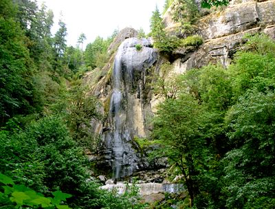
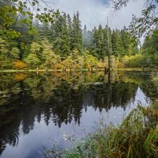
Golden and Silver Falls is a natural area in the coastal forests of southwestern Oregon that protects two striking waterfalls. The falls drop approximately 100 feet over rock cliffs and land on moss-covered boulders surrounded by thick old-growth trees.

Waterford Lumber Company donated the initial land for the park in 1936 after Coos County and Oregon state improved road access for logging operations. This cooperation between private business and public agencies shaped the park's creation.

The name Golden Falls honors Dr. C. B. Golden, the first grand chancellor of Knights of Pythias of Oregon who visited the location. This connection to local history becomes part of the experience as visitors approach the waterfall.

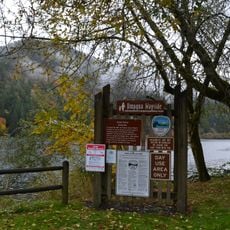
Access is by a narrow gravel road that extends three miles to a parking area with picnic facilities. The hiking route to the waterfall is well marked and requires only moderate physical effort.

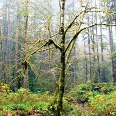
The hiking trail to Golden Falls passes through a forest of old-growth firs and cedars that have stood for centuries. These ancient trees create a distinctive backdrop that many visitors find memorable.

The community of curious travelers

AroundUs brings together thousands of curated places, local tips, and hidden gems, enriched daily by 60,000 contributors worldwide.

Start exploring
Location
GPS coordinates
43.48460,-123.93200
Latest update
December 12, 2025 17:42
Around this place
Oregon Dunes National Recreation Area
United States of America

Oregon Dunes National Recreation Area

33.2 km
Conde McCullough Memorial Bridge
United States of America

Conde McCullough Memorial Bridge

24.3 km
Sunset Bay State Park
United States of America

Sunset Bay State Park

39.4 km
Umpqua River Light
United States of America

Umpqua River Light

29.2 km
Elliott State Forest
United States of America

Elliott State Forest

13.1 km
William M. Tugman State Park
United States of America

William M. Tugman State Park

23.6 km
Coast Guard Air Station North Bend
United States of America

Coast Guard Air Station North Bend

26.3 km
Egyptian Theatre
United States of America

Egyptian Theatre

26.2 km
Fort Umpqua
United States of America

Fort Umpqua

33.5 km
Devil's Staircase Wilderness
United States of America

Devil's Staircase Wilderness

26.2 km
Umpqua State Scenic Corridor
United States of America

Umpqua State Scenic Corridor

18.7 km
Umpqua River Bridge
United States of America

Umpqua River Bridge

28.5 km
Dean Creek Wildlife Area
United States of America

Dean Creek Wildlife Area

25 km
Cape Arago Lighthouse
United States of America

Cape Arago Lighthouse

39.2 km
Haynes Inlet Bridge
United States of America

Haynes Inlet Bridge

23.8 km
Coos Bay National Bank Building
United States of America

Coos Bay National Bank Building

26.3 km
Coos History Museum
United States of America

Coos History Museum

25.7 km
Marine life center
United States of America

Marine life center

35.6 km
J. S. Coke Building
United States of America

J. S. Coke Building

26.2 km
Chandler Hotel and Annex
United States of America

Chandler Hotel and Annex

26.2 km
Port Theater
United States of America

Port Theater

25.2 km
Liberty Theatre
United States of America

Liberty Theatre

25.2 km
Chandler Bridge
United States of America

Chandler Bridge

22.2 km
Gardiner Historic District
United States of America

Gardiner Historic District

30.9 km
Gardiner Cemetery
United States of America

Gardiner Cemetery

31.4 km
Scottsburg Bridge
United States of America

Scottsburg Bridge

20.7 km
Scottsburg Bridge
United States of America

Scottsburg Bridge

20.7 km
Cape Arago Highway
United States of America

Cape Arago Highway

31.9 km
Show the full map
« Golden and Silver Falls State Natural Area - Natural park and waterfalls area in Coos County, United States » is provided by Around Us (aroundus.com). Images and texts are derived from Wikimedia project under a Creative Commons license. You are allowed to copy, distribute, and modify copies of this page, under the conditions set by the license, as long as this note is clearly visible.

Discover hidden gems everywhere you go!

From secret cafés to breathtaking viewpoints, skip the crowded tourist spots and find places that match your style. Our app makes it easy with voice search, smart filtering, route optimization, and insider tips from travelers worldwide. Download now for the complete mobile experience.

Around Us App Screenshot

A unique approach to discovering new places

Le Figaro

All the places worth exploring

France Info

A tailor-made excursion in just a few clicks

20 Minutes

Around Us
Travel Guide & Maps
Download

Send to your phone

QR Code
1

Open the camera app on your mobile.

2

Point at the QR code with your camera. A notification will appear.

3

Tap the notification to open the link.