Enable Location

We need your location to show you interesting places around you

Discover nearby places

Find interesting locations and hidden gems around you

Precise directions

Get accurate directions and distances to places

Your location is never shared with other users. It's only used when you tap the location button.

Dexter Reservoir

Log in to your account

Start exploring — it's free

Trusted by 62,314 travelers worldwide

Continue with Google
Continue with Apple
or

We will send you a code to connect

By continuing, you accept our Terms and Conditions and our Privacy Policy

Check your inbox

We've sent a pincode in your inbox. Please enter the code below.

Dexter Reservoir

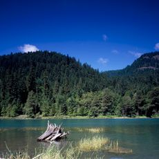
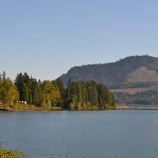
Dexter Reservoir, reservoir in Oregon

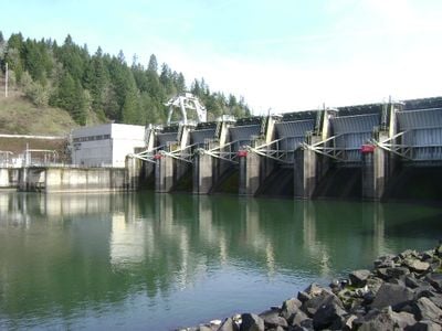
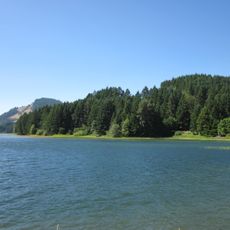
Dexter Reservoir is a large lake in Lane County created by damming the Middle Fork Willamette River in the 1950s. The water is managed by a facility that also generates electricity, while oak and Douglas fir forests surround the basin.

The lake was created in 1954 by the U.S. Army Corps of Engineers as part of a regional hydroelectric project. The dam helps control flooding and provides electricity while keeping water levels more stable than the upstream Lookout Point Lake.

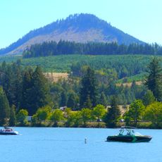
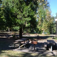
The reservoir serves as a gathering place for families, anglers, and outdoor enthusiasts who visit regularly to fish or relax by the water. The disc golf course set among the trees draws players especially on weekends, creating a social hub for people of all skill levels.

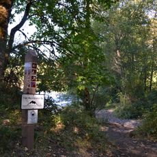
Access to the lake is through a public boat ramp and parking areas that require a day permit. Dogs must be kept on leashes, swimming is not actively promoted, but boating, fishing, and hiking on surrounding trails are popular activities.

The reservoir is known for regular contests to catch pikeminnow, fish that harm the local ecosystem. These community efforts help keep fish populations healthy and improve fishing results for all visitors.

The community of curious travelers

AroundUs brings together thousands of curated places, local tips, and hidden gems, enriched daily by 60,000 contributors worldwide.

Start exploring
Location
GPS coordinates
43.92361,-122.80667
Latest update
February 7, 2026 11:00
Around this place
Cascades Raptor Center
United States of America

Cascades Raptor Center

23 km
Hendricks Park
United States of America

Hendricks Park

23.6 km
Dorena Reservoir
United States of America

Dorena Reservoir

19.3 km
Hayden Bridge
United States of America

Hayden Bridge

20.8 km
Lookout Point Lake
United States of America

Lookout Point Lake

7.1 km
Mount Pisgah Arboretum
United States of America

Mount Pisgah Arboretum

16.9 km
Elijah Bristow State Park
United States of America

Elijah Bristow State Park

537 m
Dexter State Recreation Site
United States of America

Dexter State Recreation Site

787 m
Lowell State Recreation Site
United States of America

Lowell State Recreation Site

793 m
Jasper State Recreation Site
United States of America

Jasper State Recreation Site

10.1 km
Lowell Bridge
United States of America

Lowell Bridge

2.6 km
Washburne Historic District
United States of America

Washburne Historic District

21.9 km
Mosby Creek Bridge
United States of America

Mosby Creek Bridge

22.7 km
Currin Bridge
United States of America

Currin Bridge

20.9 km
Brattain–Hadley House
United States of America

Brattain–Hadley House

21 km
Whilamut Passage Bridge
United States of America

Whilamut Passage Bridge

23.7 km
Pengra Bridge
United States of America

Pengra Bridge

5.6 km
Parvin Bridge
United States of America

Parvin Bridge

2.9 km
Dorena Bridge
United States of America

Dorena Bridge

21.6 km
Unity Bridge
United States of America

Unity Bridge

3.6 km
Stewart Bridge
United States of America

Stewart Bridge

23.1 km
Lowell Grange
United States of America

Lowell Grange

2 km
Methodist Episcopal Church of Goshen
United States of America

Methodist Episcopal Church of Goshen

18.2 km
Cochran-Rice Farm Complex
United States of America

Cochran-Rice Farm Complex

23.7 km
Robert E. Campbell House
United States of America

Robert E. Campbell House

23.8 km
Jacob Clearwater House
United States of America

Jacob Clearwater House

16.3 km
Dorris Ranch Living History Farm
United States of America

Dorris Ranch Living History Farm

20.6 km
Springfield Bridge
United States of America

Springfield Bridge

22.3 km
Show the full map
« Dexter Reservoir - reservoir in Oregon » is provided by Around Us (aroundus.com). Images and texts are derived from Wikimedia project under a Creative Commons license. You are allowed to copy, distribute, and modify copies of this page, under the conditions set by the license, as long as this note is clearly visible.

Discover hidden gems everywhere you go!

From secret cafés to breathtaking viewpoints, skip the crowded tourist spots and find places that match your style. Our app makes it easy with voice search, smart filtering, route optimization, and insider tips from travelers worldwide. Download now for the complete mobile experience.

Around Us App Screenshot

A unique approach to discovering new places

Le Figaro

All the places worth exploring

France Info

A tailor-made excursion in just a few clicks

20 Minutes

Around Us
Travel Guide & Maps
Download

Send to your phone

QR Code
1

Open the camera app on your mobile.

2

Point at the QR code with your camera. A notification will appear.

3

Tap the notification to open the link.