Chest opened
+${chestReward.xp} XP
Explorer
NOUVEAU ×${chestReward.collectible.quantity}
tapez pour fermer
Chest locked

Open chests in the app

Around Us is built for your phone — chests unlock when you walk, explore and capture nearby places.

Enable Location

We need your location to show you interesting places around you

Discover nearby places

Find interesting locations and hidden gems around you

Precise directions

Get accurate directions and distances to places

Your location is never shared with other users. It's only used when you tap the location button.

Cascadia subduction zone

Log in to your account

Start exploring — it's free

Trusted by 72,881 travelers worldwide

Continue with Google
Continue with Apple
or

We will send you a code to connect

By continuing, you accept our Terms and Conditions and our Privacy Policy

Check your inbox

We've sent a pincode in your inbox. Please enter the code below.

Cascadia subduction zone
Discussion Reviews 1 Photos
175k Popularity

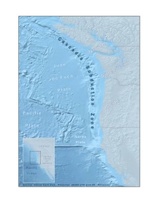
Cascadia subduction zone, Major seismic fault zone along Pacific Coast, United States and Canada

The Cascadia subduction zone is a major fault between two tectonic plates beneath the Pacific Ocean floor off the North American coast, running from northern California through to British Columbia. The zone marks the boundary where the Juan de Fuca plate slides under the North American plate and extends roughly 700 miles in length.

On January 26, 1700, a magnitude 9 earthquake struck here, with effects reaching across to Japan and prompting records there of arriving tsunami waves. Indigenous peoples along the coast preserved accounts of the event through generations, which later matched scientific data.

Indigenous peoples of the Pacific Northwest preserved knowledge of past earthquakes through oral traditions, documenting land changes and ocean patterns.

Scientists monitor this fault continuously using sensors along the coast to track movements in the crust. The collected data helps regional authorities develop evacuation plans and early warning systems for communities along the Pacific coastal region.

Along the coast stand what are called ghost forests with dead tree stumps that sank below sea level during the last major earthquake. These preserved remains show clearly how the land dropped abruptly during earlier events, in some areas settling several meters lower than before.

The community of curious travelers

AroundUs brings together thousands of curated places, local tips, and hidden gems, enriched daily by 60,000 contributors worldwide.

Start exploring
Location
Location
Location
Location
GPS coordinates
45.00000,-124.00000
Latest update
December 12, 2025 20:50
Reviews
Share your experience

No review yet

Discussions
Start a discussion...

No discussion yet

« Cascadia subduction zone - Major seismic fault zone along Pacific Coast, United States and Canada » is provided by Around Us (aroundus.com). Images and texts are derived from Wikimedia project under a Creative Commons license. You are allowed to copy, distribute, and modify copies of this page, under the conditions set by the license, as long as this note is clearly visible.

Discover hidden gems everywhere you go!

From secret cafés to breathtaking viewpoints, skip the crowded tourist spots and find places that match your style. Our app makes it easy with voice search, smart filtering, route optimization, and insider tips from travelers worldwide. Download now for the complete mobile experience.

Around Us App Screenshot

A unique approach to discovering new places

Le Figaro

All the places worth exploring

France Info

A tailor-made excursion in just a few clicks

20 Minutes

Around Us
Travel Guide & Maps
Download

Send to your phone

QR Code
1

Open the camera app on your mobile.

2

Point at the QR code with your camera. A notification will appear.

3

Tap the notification to open the link.