Enable Location

We need your location to show you interesting places around you

Discover nearby places

Find interesting locations and hidden gems around you

Precise directions

Get accurate directions and distances to places

Your location is never shared with other users. It's only used when you tap the location button.

Drift Creek Bridge

Log in to your account

Start exploring — it's free

Trusted by 61,895 travelers worldwide

Continue with Google
Continue with Apple
or

We will send you a code to connect

By continuing, you accept our Terms and Conditions and our Privacy Policy

Check your inbox

We've sent a pincode in your inbox. Please enter the code below.

Drift Creek Bridge

Drift Creek Bridge, Wooden covered bridge in Lincoln County, Oregon

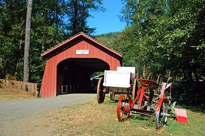
Drift Creek Bridge is a wooden covered structure spanning Bear Creek with a Howe truss framework and board-and-batten siding throughout. The passage features arched portals at both ends and ribbon windows under the eaves that allow light inside and let visitors observe the timber frame details.

This bridge was built in 1914 and originally served as a key traffic route along the Oregon coast until newer roads redirected travel in the 1960s. The change left it at risk, setting the stage for community-led restoration efforts decades later.

Local residents rallied to save this structure, showing how much the community values its connection to early transportation history. The bridge draws visitors who appreciate the craftsmanship of 1910s engineering and rural heritage.

The best way to reach it is to drive north from Lincoln City on Highway 101, then east on Highway 18 to Bear Creek Road. The route is straightforward through rural terrain with clear signage leading you right to the parking area.

The entire structure was disassembled in 1997 and reconstructed at its current location using the original timber pieces. This extensive dismantling and rebuilding process is uncommon and reflects how serious the community was about preserving this heritage.

The community of curious travelers

AroundUs brings together thousands of curated places, local tips, and hidden gems, enriched daily by 60,000 contributors worldwide.

Start exploring
Location
Inception
1914
GPS coordinates
44.99308,-123.88644
Latest update
December 14, 2025 14:25
Around this place
Devils Punch Bowl State Natural Area
United States of America

Devils Punch Bowl State Natural Area

30.9 km
Cape Kiwanda State Natural Area
United States of America

Cape Kiwanda State Natural Area

25.8 km
Cascade Head
United States of America

Cascade Head

23.5 km
Chinook Winds Casino
United States of America

Chinook Winds Casino

9.7 km
Whale Watching Center
United States of America

Whale Watching Center

24.6 km
Devils Punchbowl State Natural Area
United States of America

Devils Punchbowl State Natural Area

30.8 km
Fort Yamhill
United States of America

Fort Yamhill

26.3 km
H. B. Van Duzer Forest State Scenic Corridor
United States of America

H. B. Van Duzer Forest State Scenic Corridor

8.7 km
Boiler Bay State Scenic Viewpoint
United States of America

Boiler Bay State Scenic Viewpoint

23.1 km
Devil's Lake State Recreation Area
United States of America

Devil's Lake State Recreation Area

10.2 km
Bob Straub State Park
United States of America

Bob Straub State Park

22 km
Siletz Bay National Wildlife Refuge
United States of America

Siletz Bay National Wildlife Refuge

14.5 km
Salmon River
United States of America

Salmon River

4.9 km
D River State Recreation Site
United States of America

D River State Recreation Site

10.7 km
Neskowin Beach State Recreation Site
United States of America

Neskowin Beach State Recreation Site

14.4 km
Nestucca Bay National Wildlife Refuge
United States of America

Nestucca Bay National Wildlife Refuge

20.5 km
Devil's Punchbowl
United States of America

Devil's Punchbowl

30.8 km
Otter Crest State Scenic Viewpoint
United States of America

Otter Crest State Scenic Viewpoint

29.5 km
Roads End State Recreation Site
United States of America

Roads End State Recreation Site

9.8 km
Rocky Creek State Scenic Viewpoint
United States of America

Rocky Creek State Scenic Viewpoint

27.7 km
Fogarty Creek State Recreation Area
United States of America

Fogarty Creek State Recreation Area

21 km
Gleneden Beach State Recreation Site
United States of America

Gleneden Beach State Recreation Site

17.5 km
Depoe Bay Bridge
United States of America

Depoe Bay Bridge

24.6 km
Rocky Creek Bridge
United States of America

Rocky Creek Bridge

28 km
Neskowin Beach
United States of America

Neskowin Beach

14.5 km
Whale Research EcoExcursions
United States of America

Whale Research EcoExcursions

24.7 km
Kiwanda Beach
United States of America

Kiwanda Beach

18.9 km
Bijou Theatre
United States of America

Bijou Theatre

10 km
Show the full map
« Drift Creek Bridge - Wooden covered bridge in Lincoln County, Oregon » is provided by Around Us (aroundus.com). Images and texts are derived from Wikimedia project under a Creative Commons license. You are allowed to copy, distribute, and modify copies of this page, under the conditions set by the license, as long as this note is clearly visible.

Discover hidden gems everywhere you go!

From secret cafés to breathtaking viewpoints, skip the crowded tourist spots and find places that match your style. Our app makes it easy with voice search, smart filtering, route optimization, and insider tips from travelers worldwide. Download now for the complete mobile experience.

Around Us App Screenshot

A unique approach to discovering new places

Le Figaro

All the places worth exploring

France Info

A tailor-made excursion in just a few clicks

20 Minutes

Around Us
Travel Guide & Maps
Download

Send to your phone

QR Code
1

Open the camera app on your mobile.

2

Point at the QR code with your camera. A notification will appear.

3

Tap the notification to open the link.