Chest opened
+${chestReward.xp} XP
Explorer
NOUVEAU ×${chestReward.collectible.quantity}
tapez pour fermer
Chest locked

Open chests in the app

Around Us is built for your phone — chests unlock when you walk, explore and capture nearby places.

Enable Location

We need your location to show you interesting places around you

Discover nearby places

Find interesting locations and hidden gems around you

Precise directions

Get accurate directions and distances to places

Your location is never shared with other users. It's only used when you tap the location button.

Deschutes National Forest

Log in to your account

Start exploring — it's free

Trusted by 72,996 travelers worldwide

Continue with Google
Continue with Apple
or

We will send you a code to connect

By continuing, you accept our Terms and Conditions and our Privacy Policy

Check your inbox

We've sent a pincode in your inbox. Please enter the code below.

Deschutes National Forest
Discussion Reviews 1 Photos
12.3k Popularity

Deschutes National Forest, National forest in Central Oregon, United States.

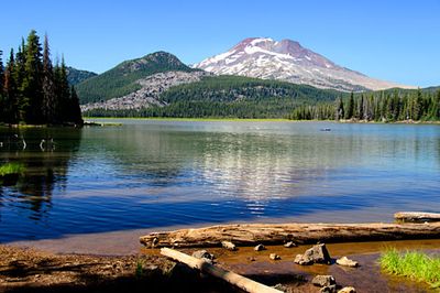
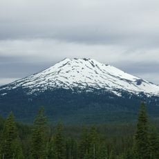
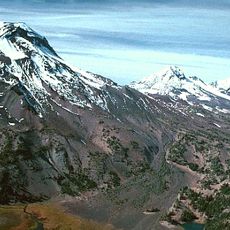
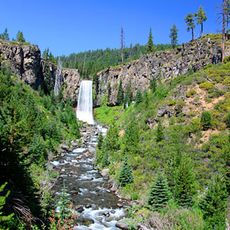
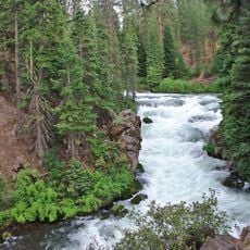
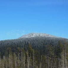
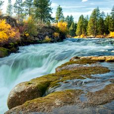
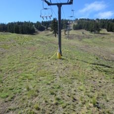
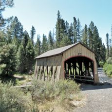
Deschutes National Forest covers approximately 1.6 million acres along the Cascade Range with volcanic features like cinder cones and lava flows throughout. The landscape is crossed by thousands of miles of trails that lead through different terrain and elevation zones.

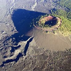
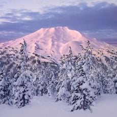
The forest was established in 1908 as a protected area in Central Oregon. Between 1964 and 1966, astronauts training for Apollo missions used the volcanic terrain near Newberry Volcano to prepare for lunar exploration.

The Klamath and Wasco peoples used this land for hunting and gathering food for countless generations. Today visitors can experience this connection when they walk through the forest and see how people still harvest resources like mushrooms here.

You can reach the forest through ranger district offices in Bend, Crescent, and Sisters where staff provide maps and permits for camping and special activities. Spring through fall offers the best conditions for exploring the trails, though some higher elevations may have snow late into the season.

Special permits are issued during specific seasons for harvesting matsutake mushrooms, which allows people to practice traditional foraging while protecting the resource. This system creates a unique opportunity for visitors to participate in an activity that has roots in both local traditions and modern conservation.

The community of curious travelers

AroundUs brings together thousands of curated places, local tips, and hidden gems, enriched daily by 60,000 contributors worldwide.

Start exploring
Location
GPS coordinates
44.00000,-121.50000
Latest update
December 7, 2025 20:46
Around this place
Mount Bachelor
United States of America

Mount Bachelor

15.3 km
Lava River Cave
United States of America

Lava River Cave

15.7 km
Lava Butte
United States of America

Lava Butte

14.7 km
Three Sisters Wilderness
United States of America

Three Sisters Wilderness

0 m
Tumalo Falls
United States of America

Tumalo Falls

6.5 km
Les Schwab Amphitheater
United States of America

Les Schwab Amphitheater

15.5 km
High Desert Museum
United States of America

High Desert Museum

13.2 km
Benham Falls
United States of America

Benham Falls

9.7 km
Camp Abbot
United States of America

Camp Abbot

14.8 km
Tumalo Mountain
United States of America

Tumalo Mountain

11.4 km
Mt. Bachelor
United States of America

Mt. Bachelor

14.8 km
Thomas McCann House
United States of America

Thomas McCann House

15.9 km
Dillon Falls
United States of America

Dillon Falls

8.4 km
George Palmer and Dorothy Binney Putnam House
United States of America

George Palmer and Dorothy Binney Putnam House

16 km
Reid School
United States of America

Reid School

15.9 km
Old Bend High School
United States of America

Old Bend High School

16 km
Sunriver Observatory
United States of America

Sunriver Observatory

13.5 km
Deschutes Public Library Administration Building
United States of America

Deschutes Public Library Administration Building

16 km
Congress Apartments
United States of America

Congress Apartments

15.5 km
Evan Andreas Sather House
United States of America

Evan Andreas Sather House

15.9 km
Robert D. Moore House
United States of America

Robert D. Moore House

15.9 km
Emil and Ottilie Wienecke House
United States of America

Emil and Ottilie Wienecke House

15.7 km
Peter Byberg House
United States of America

Peter Byberg House

15.6 km
Simpson E. Jones House
United States of America

Simpson E. Jones House

16 km
Lava Butte Lookout
United States of America

Lava Butte Lookout

14.7 km
The Village at Sunriver
United States of America

The Village at Sunriver

15 km
Bachelor Ski Lift (historical)
United States of America

Bachelor Ski Lift (historical)

14.5 km
Hixon Crossing Covered Bridge
United States of America

Hixon Crossing Covered Bridge

12.4 km
Show the full map
Reviews
Share your experience

No review yet

Discussions
Start a discussion...

No discussion yet

« Deschutes National Forest - National forest in Central Oregon, United States » is provided by Around Us (aroundus.com). Images and texts are derived from Wikimedia project under a Creative Commons license. You are allowed to copy, distribute, and modify copies of this page, under the conditions set by the license, as long as this note is clearly visible.

Discover hidden gems everywhere you go!

From secret cafés to breathtaking viewpoints, skip the crowded tourist spots and find places that match your style. Our app makes it easy with voice search, smart filtering, route optimization, and insider tips from travelers worldwide. Download now for the complete mobile experience.

Around Us App Screenshot

A unique approach to discovering new places

Le Figaro

All the places worth exploring

France Info

A tailor-made excursion in just a few clicks

20 Minutes

Around Us
Travel Guide & Maps
Download

Send to your phone

QR Code
1

Open the camera app on your mobile.

2

Point at the QR code with your camera. A notification will appear.

3

Tap the notification to open the link.