Chest opened
+${chestReward.xp} XP
Explorer
NOUVEAU ×${chestReward.collectible.quantity}
tapez pour fermer
Chest locked

Open chests in the app

Around Us is built for your phone — chests unlock when you walk, explore and capture nearby places.

Enable Location

We need your location to show you interesting places around you

Discover nearby places

Find interesting locations and hidden gems around you

Precise directions

Get accurate directions and distances to places

Your location is never shared with other users. It's only used when you tap the location button.

Sauvie Island

Log in to your account

Start exploring — it's free

Trusted by 72,976 travelers worldwide

Continue with Google
Continue with Apple
or

We will send you a code to connect

By continuing, you accept our Terms and Conditions and our Privacy Policy

Check your inbox

We've sent a pincode in your inbox. Please enter the code below.

Sauvie Island
Discussion Reviews 1 Photos
29.7k Popularity

Sauvie Island, River island in Multnomah County and Columbia County, United States.

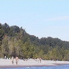
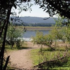
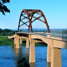
Sauvie Island is a large river island along the Columbia River featuring farmland, wildlife areas, and public beaches situated about 10 miles from Portland, Oregon. The island is reached by Wapato Bridge and offers a network of low-traffic roads throughout.

The island was home to the Multnomah band of the Chinook Tribe, who established multiple villages here before European contact. Their settlement patterns shaped how the landscape was used long before it became agricultural land.

Local farms across the island invite visitors to pick seasonal crops like berries and pumpkins, creating a direct connection between people and the land. This hands-on approach reflects how the community views its relationship with the soil.

The best time to visit is during harvest seasons when farms offer picking activities and roads are ideal for cycling. Visitors should come prepared for outdoor activities and variable weather conditions throughout the year.

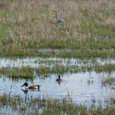
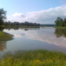
Sturgeon Lake sits at the center of the island, attracting numerous bird species and serving as a vital stopover for migrating birds throughout the year. This lake often goes unnoticed despite being the ecological heart of the place.

The community of curious travelers

AroundUs brings together thousands of curated places, local tips, and hidden gems, enriched daily by 60,000 contributors worldwide.

Start exploring
Location
Location
GPS coordinates
45.71650,-122.80121
Latest update
December 21, 2025 16:05
Around this place
Collins Beach
United States of America

Collins Beach

8.6 km
Course of the Willamette River
United States of America

Course of the Willamette River

7.6 km
Peace Candle of the World
United States of America

Peace Candle of the World

6.5 km
Burlington Northern Railroad Bridge 9.6
United States of America

Burlington Northern Railroad Bridge 9.6

13.3 km
Kelley Point Park
United States of America

Kelley Point Park

8 km
Ridgefield National Wildlife Refuge
United States of America

Ridgefield National Wildlife Refuge

11 km
Smith and Bybee Wetlands Natural Area
United States of America

Smith and Bybee Wetlands Natural Area

11.2 km
Esther Short Park
United States of America

Esther Short Park

14 km
Wapato Bridge
United States of America

Wapato Bridge

9.9 km
Sauvie Island Wildlife Area
United States of America

Sauvie Island Wildlife Area

462 m
Covington House
United States of America

Covington House

12.7 km
Oregon Slough Railroad Bridge
United States of America

Oregon Slough Railroad Bridge

13.7 km
Kiggins Theatre
United States of America

Kiggins Theatre

14 km
Clark County Historical Museum
United States of America

Clark County Historical Museum

13.7 km
Pier Park
United States of America

Pier Park

13.1 km
Slocum House
United States of America

Slocum House

13.4 km
Bybee–Howell House
United States of America

Bybee–Howell House

8.5 km
The Pioneer Mother Memorial
United States of America

The Pioneer Mother Memorial

14 km
Hidden Houses
United States of America

Hidden Houses

13.9 km
Salmon Run Bell Tower
United States of America

Salmon Run Bell Tower

14.1 km
Willamette River Light
United States of America

Willamette River Light

7.7 km
Vancouver Telephone Building
United States of America

Vancouver Telephone Building

14 km
Basalt Cobblestone Quarries District
United States of America

Basalt Cobblestone Quarries District

14.1 km
Elks Building
United States of America

Elks Building

14.1 km
John P. and Mary Kiggins House
United States of America

John P. and Mary Kiggins House

14.2 km
Hazel Dell Lanes
United States of America

Hazel Dell Lanes

11.8 km
Clark County Courthouse
United States of America

Clark County Courthouse

13.6 km
Reeder Beach
United States of America

Reeder Beach

2.4 km
Show the full map
Reviews
Share your experience

No review yet

Discussions
Start a discussion...

No discussion yet

« Sauvie Island - River island in Multnomah County and Columbia County, United States » is provided by Around Us (aroundus.com). Images and texts are derived from Wikimedia project under a Creative Commons license. You are allowed to copy, distribute, and modify copies of this page, under the conditions set by the license, as long as this note is clearly visible.

Discover hidden gems everywhere you go!

From secret cafés to breathtaking viewpoints, skip the crowded tourist spots and find places that match your style. Our app makes it easy with voice search, smart filtering, route optimization, and insider tips from travelers worldwide. Download now for the complete mobile experience.

Around Us App Screenshot

A unique approach to discovering new places

Le Figaro

All the places worth exploring

France Info

A tailor-made excursion in just a few clicks

20 Minutes

Around Us
Travel Guide & Maps
Download

Send to your phone

QR Code
1

Open the camera app on your mobile.

2

Point at the QR code with your camera. A notification will appear.

3

Tap the notification to open the link.