Enable Location

We need your location to show you interesting places around you

Discover nearby places

Find interesting locations and hidden gems around you

Precise directions

Get accurate directions and distances to places

Your location is never shared with other users. It's only used when you tap the location button.

Wapato Bridge

Log in to your account

Start exploring — it's free

Trusted by 61,865 travelers worldwide

Continue with Google
Continue with Apple
or

We will send you a code to connect

By continuing, you accept our Terms and Conditions and our Privacy Policy

Check your inbox

We've sent a pincode in your inbox. Please enter the code below.

Wapato Bridge

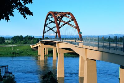
Wapato Bridge, Tied-arch bridge in Multnomah County, Oregon, US.

Description

Wapato Bridge is a tied-arch structure spanning the Multnomah Channel of the Columbia River, connecting urban areas with Sauvie Island's agricultural lands. The structure features two traffic lanes with shoulders and sidewalks designed to support modern commercial and farm transportation.

History

The bridge opened in 2008, replacing an earlier 1950 structure that could no longer handle the demands of modern truck traffic. Its design was developed specifically to support the heavy agricultural transportation needs serving the island.

Culture

The bridge was named in 2023 to honor the wapato plant, which held deep importance for Native American communities who originally inhabited Sauvie Island. This naming reflects the traditional knowledge and connection those communities maintained with the region and its resources.

Practical

The bridge offers straightforward crossing with clear lanes and pedestrian paths that accommodate all types of traffic easily. The flat design and wide structure make it simple to use regardless of the season or weather conditions.

Did you know?

The bridge uses weathering steel that develops a protective rust layer over time instead of requiring regular paint maintenance. This material choice gives the structure its distinctive brown and golden tone that blends naturally with the surrounding farmland.

Location
Location
Inception
June 23, 2008
Official opening
June 23, 2008
GPS coordinates
45.62800,-122.81600
Latest update
December 12, 2025 12:03

AroundUs brings together thousands of curated places, local tips, and hidden gems, enriched daily by 60,000 contributors worldwide. Discover all places nearby (Oregon).

Around this place
Show the full map
« Wapato Bridge - Tied-arch bridge in Multnomah County, Oregon, US » is provided by Around Us (aroundus.com). Images and texts are derived from Wikimedia project under a Creative Commons license. You are allowed to copy, distribute, and modify copies of this page, under the conditions set by the license, as long as this note is clearly visible.

Discover hidden gems everywhere you go!

From secret cafés to breathtaking viewpoints, skip the crowded tourist spots and find places that match your style. Our app makes it easy with voice search, smart filtering, route optimization, and insider tips from travelers worldwide. Download now for the complete mobile experience.

Around Us App Screenshot

A unique approach to discovering new places

Le Figaro

All the places worth exploring

France Info

A tailor-made excursion in just a few clicks

20 Minutes

Around Us
Travel Guide & Maps
Download

Send to your phone

QR Code
1

Open the camera app on your mobile.

2

Point at the QR code with your camera. A notification will appear.

3

Tap the notification to open the link.