Chest opened
+${chestReward.xp} XP
Explorer
NOUVEAU ×${chestReward.collectible.quantity}
tapez pour fermer
Chest locked

Open chests in the app

Around Us is built for your phone — chests unlock when you walk, explore and capture nearby places.

Enable Location

We need your location to show you interesting places around you

Discover nearby places

Find interesting locations and hidden gems around you

Precise directions

Get accurate directions and distances to places

Your location is never shared with other users. It's only used when you tap the location button.

Destruction Island

Log in to your account

Start exploring — it's free

Trusted by 72,886 travelers worldwide

Continue with Google
Continue with Apple
or

We will send you a code to connect

By continuing, you accept our Terms and Conditions and our Privacy Policy

Check your inbox

We've sent a pincode in your inbox. Please enter the code below.

Destruction Island
Discussion Reviews 1 Photos
10.8k Popularity

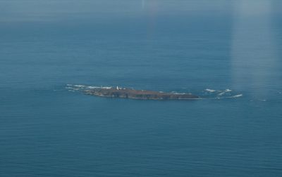
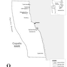
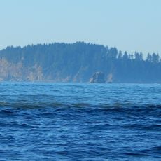
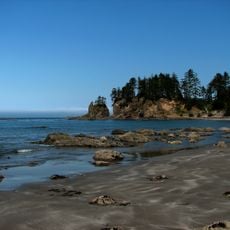
Destruction Island, Protected island off Jefferson County, Washington

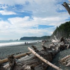
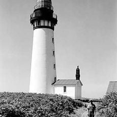
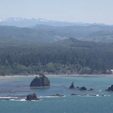
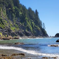
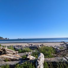
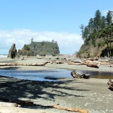
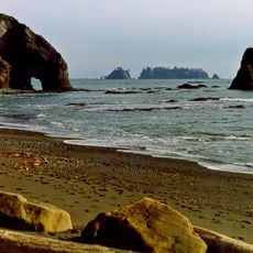
Destruction Island is a protected island off the coast of Washington that rises steeply from the Pacific Ocean with rocky cliffs and rugged terrain. A lighthouse stands on the island and can be seen from Ruby Beach nearby.

A Spanish explorer named the island in 1775 after a tragedy when some of his crew members died while attempting to land. This incident gave the island its lasting name and dark reputation.

The Hoh people traditionally came to this island to hunt rhinoceros auklets, which were a vital food source for their community. This hunting practice was part of their connection to the coastal waters for generations.

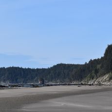
The best way to see this island and its lighthouse is from Ruby Beach, which sits along a nearby scenic road. Plan your visit around daylight hours since viewing from the shore is the only access option.

This island earned its notorious reputation partly from a series of shipwrecks that occurred in a single year during the late 1800s. Multiple vessels met their end on the rocky shores in what became a dangerous stretch of water for passing ships.

The community of curious travelers

AroundUs brings together thousands of curated places, local tips, and hidden gems, enriched daily by 60,000 contributors worldwide.

Start exploring
Location
GPS coordinates
47.67500,-124.48400
Latest update
December 8, 2025 13:44
Around this place
Hoh Rainforest
United States of America

Hoh Rainforest

46.7 km
Ruby Beach
United States of America

Ruby Beach

6.5 km
La Push Beach
United States of America

La Push Beach

28.4 km
Rialto Beach
United States of America

Rialto Beach

29.8 km
Hall of Mosses Trail
United States of America

Hall of Mosses Trail

46.5 km
Olympic Coast National Marine Sanctuary
United States of America

Olympic Coast National Marine Sanctuary

27.9 km
Destruction Island Lighthouse
United States of America

Destruction Island Lighthouse

233 m
Bogachiel State Park
United States of America

Bogachiel State Park

26.5 km
Quillayute Needles National Wildlife Refuge
United States of America

Quillayute Needles National Wildlife Refuge

39.2 km
Chow Chow Bridge
United States of America

Chow Chow Bridge

42 km
Quinault Cultural Center and Museum
United States of America

Quinault Cultural Center and Museum

39.9 km
Copalis National Wildlife Refuge
United States of America

Copalis National Wildlife Refuge

32.7 km
Forks Timber Museum
United States of America

Forks Timber Museum

29.9 km
Forks Timber Museum
United States of America

Forks Timber Museum

29.9 km
Third Beach
United States of America

Third Beach

23.8 km
First Beach
United States of America

First Beach

27.8 km
Pacific coastal area of Olympic National Park
United States of America

Pacific coastal area of Olympic National Park

24 km
Hoh Rain Forest Visitor Center
United States of America

Hoh Rain Forest Visitor Center

46 km
Beach 1
United States of America

Beach 1

14.5 km
Forks Loggers Memorial
United States of America

Forks Loggers Memorial

29.9 km
Sol Duc River Bridge
United States of America

Sol Duc River Bridge

46.4 km
Hoh Head
United States of America

Hoh Head

10.4 km
Middle Rock
United States of America

Middle Rock

8.3 km
Hole-in-the-Wall
United States of America

Hole-in-the-Wall

32.2 km
Yellow Banks
United States of America

Yellow Banks

49.2 km
Forks Visitor Information Center
United States of America

Forks Visitor Information Center

29.9 km
Three D Beach
United States of America

Three D Beach

24.7 km
Kayostia Beach
United States of America

Kayostia Beach

43 km
Show the full map
Reviews
Share your experience

No review yet

Discussions
Start a discussion...

No discussion yet

« Destruction Island - Protected island off Jefferson County, Washington » is provided by Around Us (aroundus.com). Images and texts are derived from Wikimedia project under a Creative Commons license. You are allowed to copy, distribute, and modify copies of this page, under the conditions set by the license, as long as this note is clearly visible.

Discover hidden gems everywhere you go!

From secret cafés to breathtaking viewpoints, skip the crowded tourist spots and find places that match your style. Our app makes it easy with voice search, smart filtering, route optimization, and insider tips from travelers worldwide. Download now for the complete mobile experience.

Around Us App Screenshot

A unique approach to discovering new places

Le Figaro

All the places worth exploring

France Info

A tailor-made excursion in just a few clicks

20 Minutes

Around Us
Travel Guide & Maps
Download

Send to your phone

QR Code
1

Open the camera app on your mobile.

2

Point at the QR code with your camera. A notification will appear.

3

Tap the notification to open the link.