Enable Location

We need your location to show you interesting places around you

Discover nearby places

Find interesting locations and hidden gems around you

Precise directions

Get accurate directions and distances to places

Your location is never shared with other users. It's only used when you tap the location button.

Blue Mountain School

Log in to your account

Start exploring — it's free

Trusted by 62,585 travelers worldwide

Continue with Google
Continue with Apple
or

We will send you a code to connect

By continuing, you accept our Terms and Conditions and our Privacy Policy

Check your inbox

We've sent a pincode in your inbox. Please enter the code below.

Blue Mountain School, Schule in den Vereinigten Staaten

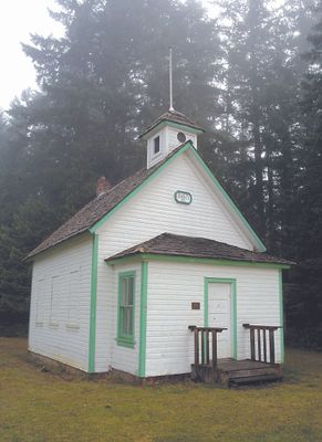
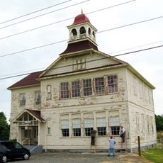
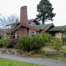
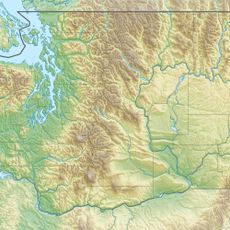
Blue Mountain School is a single-story wooden building with a brick chimney, built in 1903 and located about 8.7 miles southeast of Port Angeles on a five-acre property. The modest structure features large windows and was designed to accommodate about 19 students and one teacher.

The school was established in 1903 to serve the remote rural community and operated until 1935, when local school districts consolidated to form a larger district centered in Port Angeles. Early in the twentieth century, the building was relocated slightly and its brick chimney was rebuilt before the structure gained protection on the National Register in 1987.

The school functioned as both a classroom and the headquarters of the Blue Mountain Cemetery Association, making it a dual-purpose gathering place for the local community. People gathered here not only to learn but also for social events and meetings that bound the neighborhood together.

The building sits in a quiet rural setting about 8.7 miles from Port Angeles, which requires driving to reach, and is surrounded by trees and open fields. Wear comfortable shoes suitable for walking on dirt paths and outdoor terrain when visiting.

The property is intimately connected to an adjacent cemetery, as the school served as the headquarters of the Blue Mountain Cemetery Association and residents contributed to maintenance in exchange for burial rights. This unusual dual function reveals how remote communities consolidated multiple purposes under one location.

The community of curious travelers

AroundUs brings together thousands of curated places, local tips, and hidden gems, enriched daily by 60,000 contributors worldwide.

Start exploring
Location
GPS coordinates
48.05060,-123.27200
Latest update
February 9, 2026 07:46
Around this place
Elwha Dam
United States of America

Elwha Dam

21.7 km
Manis Mastodon Site
United States of America

Manis Mastodon Site

11.6 km
Dungeness National Wildlife Refuge
United States of America

Dungeness National Wildlife Refuge

4.9 km
New Dungeness Light
United States of America

New Dungeness Light

19.2 km
Sequim Bay State Park
United States of America

Sequim Bay State Park

18 km
Tse-whit-zen
United States of America

Tse-whit-zen

16.7 km
Mount Angeles
United States of America

Mount Angeles

15.8 km
Clallam County Courthouse
United States of America

Clallam County Courthouse

14 km
Dungeness River Bridge
United States of America

Dungeness River Bridge

10 km
United States of America

Hurricane Hill

20.3 km
Aircraft Warning Service Observation Tower
United States of America

Aircraft Warning Service Observation Tower

6.1 km
Masonic Temple
United States of America

Masonic Temple

14.1 km
Naval Lodge Elks Building
United States of America

Naval Lodge Elks Building

14.1 km
Obstruction Peak
United States of America

Obstruction Peak

16.5 km
McAlmond House
United States of America

McAlmond House

15.1 km
Dungeness School
United States of America

Dungeness School

14.9 km
Olympic National Park Headquarters Historic District
United States of America

Olympic National Park Headquarters Historic District

13.2 km
Maiden Peak
United States of America

Maiden Peak

13.4 km
Emery Farmstead
United States of America

Emery Farmstead

2.3 km
United States Post Office
United States of America

United States Post Office

14.4 km
Joseph Paris House
United States of America

Joseph Paris House

14.1 km
Estrecho Rosario
United States of America

Estrecho Rosario

4 km
Holy Trinity Lutheran Church
United States of America

Holy Trinity Lutheran Church

13.9 km
Hurricane Ridge Visitor Center
United States of America

Hurricane Ridge Visitor Center

19.1 km
St. Matthew’s Lutheran Church
United States of America

St. Matthew’s Lutheran Church

14.1 km
Olympic National Park Visitor Center
United States of America

Olympic National Park Visitor Center

12.7 km
Deer Park Campground
United States of America

Deer Park Campground

11.4 km
Obstruction Point-Deer Park Trail
United States of America

Obstruction Point-Deer Park Trail

16.9 km
Show the full map
« Blue Mountain School - Schule in den Vereinigten Staaten » is provided by Around Us (aroundus.com). Images and texts are derived from Wikimedia project under a Creative Commons license. You are allowed to copy, distribute, and modify copies of this page, under the conditions set by the license, as long as this note is clearly visible.

Discover hidden gems everywhere you go!

From secret cafés to breathtaking viewpoints, skip the crowded tourist spots and find places that match your style. Our app makes it easy with voice search, smart filtering, route optimization, and insider tips from travelers worldwide. Download now for the complete mobile experience.

Around Us App Screenshot

A unique approach to discovering new places

Le Figaro

All the places worth exploring

France Info

A tailor-made excursion in just a few clicks

20 Minutes

Around Us
Travel Guide & Maps
Download

Send to your phone

QR Code
1

Open the camera app on your mobile.

2

Point at the QR code with your camera. A notification will appear.

3

Tap the notification to open the link.