Enable Location

We need your location to show you interesting places around you

Discover nearby places

Find interesting locations and hidden gems around you

Precise directions

Get accurate directions and distances to places

Your location is never shared with other users. It's only used when you tap the location button.

Mark Clark Bridge

Log in to your account

Start exploring — it's free

Trusted by 61,596 travelers worldwide

Continue with Google
Continue with Apple
or

We will send you a code to connect

By continuing, you accept our Terms and Conditions and our Privacy Policy

Check your inbox

We've sent a pincode in your inbox. Please enter the code below.

Mark Clark Bridge

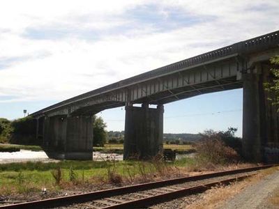
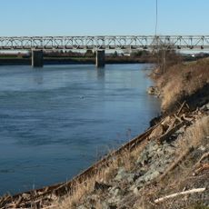
Mark Clark Bridge, Concrete bridge in Stanwood, United States.

Description

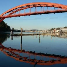
Mark Clark Bridge was a steel and concrete structure that spanned the Stillaguamish River and connected the town of Stanwood to Camano Island. The structure carried State Route 532 across the water and measured about 487 feet in length.

History

The structure opened in 1949 and was named after U.S. Army officer Mark W. Clark, who gained distinction as a leader in World War II. It replaced an older swing bridge that had operated between the two banks since 1909.

Culture

The bridge served as a vital connection for Camano Island residents because the shallow waters surrounding the island made ferry service impractical. It allowed people to travel by road instead of relying on waterways.

Practical

Visitors should know the bridge is no longer passable, as it was replaced by the newer Camano Gateway Bridge in the early 2010s and then demolished. The site today is no longer an active crossing point but may still be visited as a historical location.

Did you know?

The bridge was the only road link to Camano Island for roughly 60 years and became a lifeline for thousands of island residents. When concerns arose about structural safety, a new bridge opened in 2010 and the old structure was later demolished.

Location
Official opening
1949
GPS coordinates
48.24030,-122.38300
Latest update
December 13, 2025 12:40

AroundUs brings together thousands of curated places, local tips, and hidden gems, enriched daily by 60,000 contributors worldwide. Discover all places nearby (Washington).

Around this place
Deception Pass Bridge
United States of America

Deception Pass Bridge

26.8 km
Fort Casey
United States of America

Fort Casey

23.5 km
Fort Ebey State Park
United States of America

Fort Ebey State Park

22 km
Cama Beach Historical State Park
United States of America

Cama Beach Historical State Park

14.7 km
Camano Island State Park
United States of America

Camano Island State Park

15.2 km
Captain Whidbey Inn
United States of America

Captain Whidbey Inn

25.7 km
Admiralty Head Light
United States of America

Admiralty Head Light

23.8 km
Kayak Point County Park
United States of America

Kayak Point County Park

11.7 km
Museum of Northwest Art
United States of America

Museum of Northwest Art

18.8 km
Giant Cedar Stump
United States of America

Giant Cedar Stump

16.4 km
United States of America

Hedgebrook

27.5 km
Rainbow Bridge
United States of America

Rainbow Bridge

18.5 km
United States of America

Joseph Whidbey State Park

24.9 km
Ferry House
United States of America

Ferry House

24.5 km
Marrowstone Point Light
United States of America

Marrowstone Point Light

27.4 km
Marysville Opera House
United States of America

Marysville Opera House

25.9 km
St. Anne's Roman Catholic Church
United States of America

St. Anne's Roman Catholic Church

21.4 km
Indian Shaker Church
United States of America

Indian Shaker Church

24.8 km
Bethsaida Swedish Evangelical Lutheran Church Parsonage
United States of America

Bethsaida Swedish Evangelical Lutheran Church Parsonage

17.4 km
Stanwood IOOF Public Hall
United States of America

Stanwood IOOF Public Hall

943 m
South Whidbey State Park
United States of America

South Whidbey State Park

25.7 km
I-5 Skagit River Bridge
United States of America

I-5 Skagit River Bridge

23 km
Langley Whale Center
United States of America

Langley Whale Center

22.3 km
Olympic Theatre
United States of America

Olympic Theatre

19.8 km
Deception Pass State Park
United States of America

Deception Pass State Park

26.1 km
Lincoln Theatre
United States of America

Lincoln Theatre

20.1 km
Clyde Theatre
United States of America

Clyde Theatre

22.3 km
Skagit City School
United States of America

Skagit City School

14.5 km
Show the full map
« Mark Clark Bridge - Concrete bridge in Stanwood, United States » is provided by Around Us (aroundus.com). Images and texts are derived from Wikimedia project under a Creative Commons license. You are allowed to copy, distribute, and modify copies of this page, under the conditions set by the license, as long as this note is clearly visible.

Discover hidden gems everywhere you go!

From secret cafés to breathtaking viewpoints, skip the crowded tourist spots and find places that match your style. Our app makes it easy with voice search, smart filtering, route optimization, and insider tips from travelers worldwide. Download now for the complete mobile experience.

Around Us App Screenshot

A unique approach to discovering new places

Le Figaro

All the places worth exploring

France Info

A tailor-made excursion in just a few clicks

20 Minutes

Around Us
Travel Guide & Maps
Download

Send to your phone

QR Code
1

Open the camera app on your mobile.

2

Point at the QR code with your camera. A notification will appear.

3

Tap the notification to open the link.