Enable Location

We need your location to show you interesting places around you

Discover nearby places

Find interesting locations and hidden gems around you

Precise directions

Get accurate directions and distances to places

Your location is never shared with other users. It's only used when you tap the location button.

Marrowstone Point Light

Log in to your account

Start exploring — it's free

Trusted by 62,364 travelers worldwide

Continue with Google
Continue with Apple
or

We will send you a code to connect

By continuing, you accept our Terms and Conditions and our Privacy Policy

Check your inbox

We've sent a pincode in your inbox. Please enter the code below.

Marrowstone Point Light

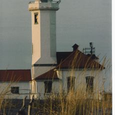
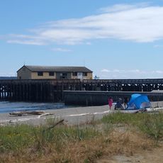
Marrowstone Point Light, Maritime navigation aid at Marrowstone Island, Jefferson County, United States

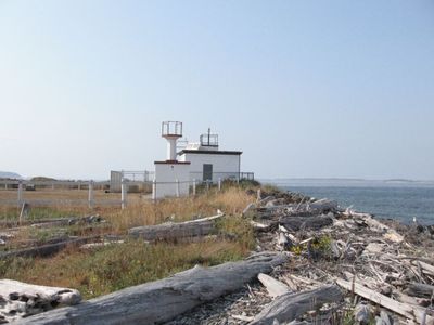
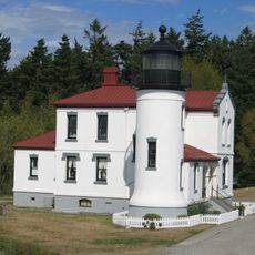
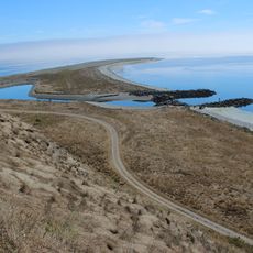
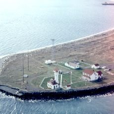
Marrowstone Point Light is a 28-foot-tall lighthouse structure at the northeast tip of Marrowstone Island that marks the entrance to Port Townsend Bay. The building sits on a sandy shoal and now operates as a marine research station.

Operations began in 1888 with a simple lens lantern on a pole and were enhanced in 1896 by the addition of a 1,200-pound fog bell. These early navigation aids proved critical for ship safety in this hazardous bay.

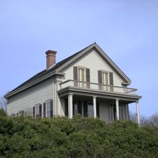
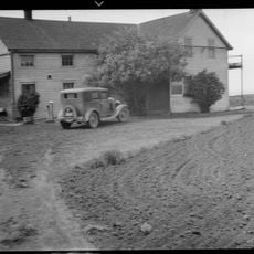
The lighthouse served as home to keepers and their families who sheltered shipwrecked sailors during storms. This human dimension reveals how the structure connected people during moments of danger.

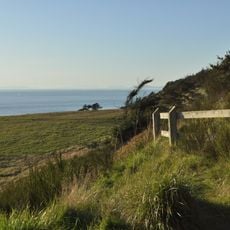
The lighthouse is visible from the beach at Fort Flagler State Park, making it easy to spot from the shore. Since the facility operates as a research station, visitors should stay on the beach or in designated park areas.

An acetylene gun for fog signaling was installed in 1914, marking one of the earliest uses of this technology at an American lighthouse. This innovation demonstrated new methods for improving signal detection in hazardous waters.

The community of curious travelers

AroundUs brings together thousands of curated places, local tips, and hidden gems, enriched daily by 60,000 contributors worldwide.

Start exploring
Location
Inception
1888
GPS coordinates
48.10180,-122.68790
Latest update
December 14, 2025 14:22
Around this place
Fort Worden
United States of America

Fort Worden

7.2 km
Fort Casey
United States of America

Fort Casey

7 km
Fort Flagler Historical State Park
United States of America

Fort Flagler Historical State Park

719 m
Fort Ebey State Park
United States of America

Fort Ebey State Park

12.8 km
Cama Beach Historical State Park
United States of America

Cama Beach Historical State Park

13.6 km
Camano Island State Park
United States of America

Camano Island State Park

14.3 km
Fort Townsend State Park
United States of America

Fort Townsend State Park

8.6 km
Captain Whidbey Inn
United States of America

Captain Whidbey Inn

13.8 km
Tamanowas Rock
United States of America

Tamanowas Rock

11.8 km
Admiralty Head Light
United States of America

Admiralty Head Light

6.6 km
Point Wilson Light
United States of America

Point Wilson Light

6.9 km
Port Townsend Historic District
United States of America

Port Townsend Historic District

5.7 km
Anderson Lake State Park
United States of America

Anderson Lake State Park

12.8 km
Port Townsend Aero Museum
United States of America

Port Townsend Aero Museum

10.2 km
Protection Island National Wildlife Refuge
United States of America

Protection Island National Wildlife Refuge

18.4 km
United States of America

Hedgebrook

14.1 km
Point Wilson
United States of America

Point Wilson

6.8 km
Rothschild House
United States of America

Rothschild House

5.3 km
Ferry House
United States of America

Ferry House

10.1 km
St. Paul's Episcopal Church
United States of America

St. Paul's Episcopal Church

5.4 km
Capt. Enoch S. Fowler House
United States of America

Capt. Enoch S. Fowler House

5.5 km
Jefferson County Courthouse
United States of America

Jefferson County Courthouse

5.9 km
Methodist Episcopal Church of Port Hadlock
United States of America

Methodist Episcopal Church of Port Hadlock

9.6 km
South Whidbey State Park
United States of America

South Whidbey State Park

8.6 km
Port Townsend Marine Science Center
United States of America

Port Townsend Marine Science Center

6.6 km
Fort Worden State Park
United States of America

Fort Worden State Park

7.2 km
Christian Congregation Church of Port Ludlow
United States of America

Christian Congregation Church of Port Ludlow

18.4 km
Port Townsend First Baptist Church
United States of America

Port Townsend First Baptist Church

5.8 km
Show the full map
« Marrowstone Point Light - Maritime navigation aid at Marrowstone Island, Jefferson County, United States » is provided by Around Us (aroundus.com). Images and texts are derived from Wikimedia project under a Creative Commons license. You are allowed to copy, distribute, and modify copies of this page, under the conditions set by the license, as long as this note is clearly visible.

Discover hidden gems everywhere you go!

From secret cafés to breathtaking viewpoints, skip the crowded tourist spots and find places that match your style. Our app makes it easy with voice search, smart filtering, route optimization, and insider tips from travelers worldwide. Download now for the complete mobile experience.

Around Us App Screenshot

A unique approach to discovering new places

Le Figaro

All the places worth exploring

France Info

A tailor-made excursion in just a few clicks

20 Minutes

Around Us
Travel Guide & Maps
Download

Send to your phone

QR Code
1

Open the camera app on your mobile.

2

Point at the QR code with your camera. A notification will appear.

3

Tap the notification to open the link.