Enable Location

We need your location to show you interesting places around you

Discover nearby places

Find interesting locations and hidden gems around you

Precise directions

Get accurate directions and distances to places

Your location is never shared with other users. It's only used when you tap the location button.

Tamanowas Rock

Log in to your account

Start exploring — it's free

Trusted by 63,114 travelers worldwide

Continue with Google
Continue with Apple
or

We will send you a code to connect

By continuing, you accept our Terms and Conditions and our Privacy Policy

Check your inbox

We've sent a pincode in your inbox. Please enter the code below.

Tamanowas Rock
Discussion Reviews 1 Photos
3.3k Popularity

Tamanowas Rock, Sacred ceremonial rock formation in Jefferson County, United States.

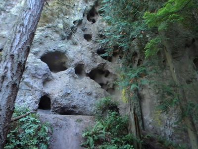
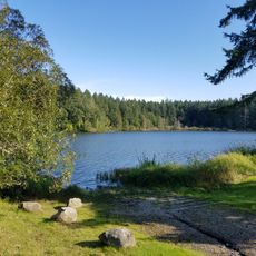
Tamanowas Rock is a massive stone formation that rises approximately 150 feet above the surrounding forest, with caves, crevices, and moss-covered surfaces throughout. The rock sits near Anderson Lake State Park and displays layered geological features shaped by ancient volcanic activity.

The site held importance for people over 10,000 years ago, who used high vantage points to hunt game in the surrounding lands. It later provided refuge when a major tsunami struck the coast in 1700.

This location holds deep meaning for the Jamestown S'Klallam people and served as a gathering space for Coast Salish communities across many generations. Visitors walking through the area can sense the spiritual importance this rock has maintained for local indigenous peoples over time.

To reach this location, head east on Anderson Lake Road from Washington State Highway 20 and follow the marked trails that lead directly to the formation. The site is best visited during daylight hours when paths are clearly visible and safe to walk.

This formation is composed of volcanic material that originated during the Eocene epoch, making it a rare geological type in the region. The distinctive composition of this ancient rock is noticeably different from other stone formations found elsewhere in Jefferson County.

The community of curious travelers

AroundUs brings together thousands of curated places, local tips, and hidden gems, enriched daily by 60,000 contributors worldwide.

Start exploring
Location
GPS coordinates
48.02208,-122.79339
Latest update
December 12, 2025 09:03
Around this place
Hood Canal Bridge
United States of America

Hood Canal Bridge

22 km
Fort Worden
United States of America

Fort Worden

13.3 km
Fort Casey
United States of America

Fort Casey

18 km
Fort Flagler Historical State Park
United States of America

Fort Flagler Historical State Park

11.1 km
Fort Townsend State Park
United States of America

Fort Townsend State Park

6 km
Captain Whidbey Inn
United States of America

Captain Whidbey Inn

22.9 km
Sequim Bay State Park
United States of America

Sequim Bay State Park

17.7 km
Admiralty Head Light
United States of America

Admiralty Head Light

17.6 km
Point Wilson Light
United States of America

Point Wilson Light

13.9 km
Port Townsend Historic District
United States of America

Port Townsend Historic District

10.8 km
Anderson Lake State Park
United States of America

Anderson Lake State Park

1.2 km
Port Townsend Aero Museum
United States of America

Port Townsend Aero Museum

4 km
Protection Island National Wildlife Refuge
United States of America

Protection Island National Wildlife Refuge

15.4 km
United States of America

Hedgebrook

18.5 km
Point Wilson
United States of America

Point Wilson

13.9 km
Rothschild House
United States of America

Rothschild House

10.8 km
Ferry House
United States of America

Ferry House

20 km
Marrowstone Point Light
United States of America

Marrowstone Point Light

11.8 km
St. Paul's Episcopal Church
United States of America

St. Paul's Episcopal Church

10.7 km
Capt. Enoch S. Fowler House
United States of America

Capt. Enoch S. Fowler House

10.5 km
Jefferson County Courthouse
United States of America

Jefferson County Courthouse

10.2 km
Methodist Episcopal Church of Port Hadlock
United States of America

Methodist Episcopal Church of Port Hadlock

2.3 km
South Whidbey State Park
United States of America

South Whidbey State Park

15.3 km
Port Townsend Marine Science Center
United States of America

Port Townsend Marine Science Center

12.9 km
Fort Worden State Park
United States of America

Fort Worden State Park

13.3 km
Christian Congregation Church of Port Ludlow
United States of America

Christian Congregation Church of Port Ludlow

11.8 km
Port Townsend First Baptist Church
United States of America

Port Townsend First Baptist Church

10.8 km
Rose Theatre
United States of America

Rose Theatre

10.6 km
Show the full map
Reviews
Share your experience

No review yet

Discussions
Start a discussion...

No discussion yet

« Tamanowas Rock - Sacred ceremonial rock formation in Jefferson County, United States » is provided by Around Us (aroundus.com). Images and texts are derived from Wikimedia project under a Creative Commons license. You are allowed to copy, distribute, and modify copies of this page, under the conditions set by the license, as long as this note is clearly visible.

Discover hidden gems everywhere you go!

From secret cafés to breathtaking viewpoints, skip the crowded tourist spots and find places that match your style. Our app makes it easy with voice search, smart filtering, route optimization, and insider tips from travelers worldwide. Download now for the complete mobile experience.

Around Us App Screenshot

A unique approach to discovering new places

Le Figaro

All the places worth exploring

France Info

A tailor-made excursion in just a few clicks

20 Minutes

Around Us
Travel Guide & Maps
Download

Send to your phone

QR Code
1

Open the camera app on your mobile.

2

Point at the QR code with your camera. A notification will appear.

3

Tap the notification to open the link.