Enable Location

We need your location to show you interesting places around you

Discover nearby places

Find interesting locations and hidden gems around you

Precise directions

Get accurate directions and distances to places

Your location is never shared with other users. It's only used when you tap the location button.

Ubehebe Crater

Log in to your account

Start exploring — it's free

Trusted by 62,839 travelers worldwide

Continue with Google
Continue with Apple
or

We will send you a code to connect

By continuing, you accept our Terms and Conditions and our Privacy Policy

Check your inbox

We've sent a pincode in your inbox. Please enter the code below.

Ubehebe Crater

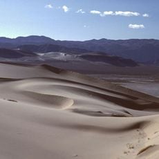
Ubehebe Crater, Volcanic crater in Death Valley National Park, United States.

Ubehebe Crater is a volcanic crater in Death Valley with a width of about half a mile and depths between 500 to 777 feet, showing exposed rock layers along its walls. The crater displays the power of geological forces that shaped this location long ago.

The crater formed roughly 2,100 years ago when magma encountered groundwater and created intense steam pressure. This explosive force was ten times stronger than the surrounding bedrock's resistance.

The Timbisha Shoshone people call this crater Tem-pin-tta-Wo'sah and hold deep ties to the volcanic landscape surrounding it. This name reflects their long connection to the land and its natural formations.

A moderate trail of about 1.5 miles circles the crater rim and provides multiple viewpoints along the route. The nearest restroom facilities are located about 5 miles away, so bring water and sun protection.

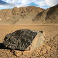
The crater floor is covered with pink and brown-colored mud flats that temporarily transform into small lakes during rare rainfall events. These temporary water surfaces form only under extreme conditions and offer a rare natural display in this otherwise dry landscape.

The community of curious travelers

AroundUs brings together thousands of curated places, local tips, and hidden gems, enriched daily by 60,000 contributors worldwide.

Start exploring
Location
GPS coordinates
37.00970,-117.45000
Latest update
December 7, 2025 19:26
Around this place
Manzanar
United States of America

Manzanar

70.1 km
Sailing stones
United States of America

Sailing stones

37.9 km
Scotty's Castle
United States of America

Scotty's Castle

10 km
Shady Lady Ranch
United States of America

Shady Lady Ranch

48 km
Saline Valley salt tram
United States of America

Saline Valley salt tram

57.4 km
Goldwell Open Air Museum
United States of America

Goldwell Open Air Museum

56.4 km
Cottontail Ranch
United States of America

Cottontail Ranch

59.5 km
Angel's Ladies
United States of America

Angel's Ladies

63.9 km
Combined Array for Research in Millimeter-wave Astronomy
United States of America

Combined Array for Research in Millimeter-wave Astronomy

68.4 km
Eureka Dunes
United States of America

Eureka Dunes

22.2 km
Saline Valley Hot Springs
United States of America

Saline Valley Hot Springs

36.7 km
Manzanar Children's Village
United States of America

Manzanar Children's Village

70 km
The Grandstand
United States of America

The Grandstand

36.8 km
Tinemaha Reservoir
United States of America

Tinemaha Reservoir

69.1 km
Manzanar National Historic Site
United States of America

Manzanar National Historic Site

70 km
Manzanar National Historic Site
United States of America

Manzanar National Historic Site

69.7 km
Racetrack mountain area
United States of America

Racetrack mountain area

37.9 km
Grapevine Peak
United States of America

Grapevine Peak

27.2 km
Lower Vine Ranch
United States of America

Lower Vine Ranch

5.7 km
Death Valley Scotty Historic District
United States of America

Death Valley Scotty Historic District

5.7 km
Beatty Museum & Historical Society
United States of America

Beatty Museum & Historical Society

62.3 km
Old Stovepipe Wells
United States of America

Old Stovepipe Wells

51.1 km
Mesquite Flat Sand Dunes
United States of America

Mesquite Flat Sand Dunes

50.1 km
Manzanar Visitor Center
United States of America

Manzanar Visitor Center

69.7 km
Beatty Museum
United States of America

Beatty Museum

62.3 km
Stovepipe Wells Campground
United States of America

Stovepipe Wells Campground

52.2 km
Manzanar Sentry Posts
United States of America

Manzanar Sentry Posts

69.5 km
Mesquite Spring Campground
United States of America

Mesquite Spring Campground

9 km
Show the full map
« Ubehebe Crater - Volcanic crater in Death Valley National Park, United States » is provided by Around Us (aroundus.com). Images and texts are derived from Wikimedia project under a Creative Commons license. You are allowed to copy, distribute, and modify copies of this page, under the conditions set by the license, as long as this note is clearly visible.

Discover hidden gems everywhere you go!

From secret cafés to breathtaking viewpoints, skip the crowded tourist spots and find places that match your style. Our app makes it easy with voice search, smart filtering, route optimization, and insider tips from travelers worldwide. Download now for the complete mobile experience.

Around Us App Screenshot

A unique approach to discovering new places

Le Figaro

All the places worth exploring

France Info

A tailor-made excursion in just a few clicks

20 Minutes

Around Us
Travel Guide & Maps
Download

Send to your phone

QR Code
1

Open the camera app on your mobile.

2

Point at the QR code with your camera. A notification will appear.

3

Tap the notification to open the link.